

A Mix of Everything (Mississauga/Toronto)
Eine Fahrradroute, die in Mississauga, Ontario, Kanada beginnt.
Übersicht
Über diese Route
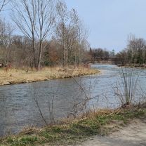
OVERVIEW: As the route says, this is essentially a mix of everything. This is a big loop that is entirely on bike trails, with a few places on bike lanes. This is one of my favorite nature/urban mixups!
ROUTE DESCRIPTION: This route begins in Celebration Square in Missisauga. The burnthamthorpe trail is taken east towards the Etobicoke Creek Trail. That trail is taken a little north, then we continue east with the Pan Am Trail onto Eglinton Ave. Upon reaching Royal York Road, we will continue north until we reach Mallaby Park. The Humber Bay Recreation Trail is taken down south all the way to the waterfront. Afterwards, we visit High Park and complete an "Ellis Loop", where we will head back west, explore Mimico (eat), and continue heading west towards Port Credit on the Waterfront Trail. After refuelling and resting at Port Credit, we'll take Hurontario up to the Cooksville Creek Trail for a nice slow scenic ending to a long journey.
LENGTH: For more experienced cyclists, this whole thing can take 2-2 1/2 hours. For regular cyclists, it should take around 3 - 3 1/2 hours. With a meal and some rest, it may extend to 5 hours. Considering you leave at 8 AM, expect to be back no later than 1-2 PM.
I hope you enjoy this route! It is a mix of both nature and an urban ride, so you get to experience both. It also covers a good perimeter of Mississauga and the eastern end of Toronto. By the way, that Ellis Loop is optional - only if you need a good workout and want to explore that park.
- -:--
- Dauer
- 71 km
- Distanz
- 510 m
- Aufstieg
- 508 m
- Abstieg
- ---
- Ø-Tempo
- 165 m
- Max. Höhe

Routenqualität
Wegtypen und Untergründe entlang der Route
Wegtypen
Radweg
39,7 km
(56 %)
Ruhige Straße
12,7 km
(18 %)
Untergründe
Befestigt
58,4 km
(82 %)
Unbefestigt
0,2 km
(<1 %)
Asphalt
55,1 km
(78 %)
Beton
2,6 km
(4 %)
Weiter mit Bikemap
Diese Radroute verwenden, bearbeiten oder herunterladen
Du möchtest A Mix of Everything (Mississauga/Toronto) fahren oder sie für deine eigene Reise anpassen? Folgendes kannst du mit dieser Bikemap-Route machen:
Gratis Funktionen
- Speichere diese Route als Favorit oder in einer Sammlung
- Kopiere & plane deine eigene Version dieser Route
- Synchronisiere deine Route mit Garmin oder Wahoo
Premium-Funktionen
Kostenlose Testversion für 3 Tage oder einmalige Zahlung. Mehr über Bikemap Premium.
- Navigiere diese Route auf iOS & Android
- Exportiere eine GPX / KML-Datei dieser Route
- Erstelle deinen individuellen Ausdruck (Jetzt kostenlos ausprobieren)
- Lade diese Route für die Offline-Navigation herunter
Entdecke weitere Premium-Funktionen.
Bikemap Premium aktivierenVon unserer Community
Mississauga: Andere beliebte Routen, die hier beginnen
 Day2_Missiisauga to Niagara Falls
- Distanz
- 119,8 km
- Aufstieg
- 385 m
- Abstieg
- 354 m
- Standort
- Mississauga, Ontario, Kanada
 Etobicoke-Lakeshore-Miss Road
- Distanz
- 40,5 km
- Aufstieg
- 133 m
- Abstieg
- 131 m
- Standort
- Mississauga, Ontario, Kanada
 2689 Hollington Cres, Mississauga to 2652 Hollington Cres, Mississauga
- Distanz
- 16,2 km
- Aufstieg
- 162 m
- Abstieg
- 161 m
- Standort
- Mississauga, Ontario, Kanada
 MBRC-Campbellville via Hwy25 Speyside climb 52km
- Distanz
- 52,1 km
- Aufstieg
- 235 m
- Abstieg
- 121 m
- Standort
- Mississauga, Ontario, Kanada
 30k around the block
- Distanz
- 29,1 km
- Aufstieg
- 124 m
- Abstieg
- 127 m
- Standort
- Mississauga, Ontario, Kanada
 Riverwood-SawmillValley-Culham Loop
- Distanz
- 10,1 km
- Aufstieg
- 90 m
- Abstieg
- 93 m
- Standort
- Mississauga, Ontario, Kanada
 Warmup Churchill to Brittania and back
- Distanz
- 23,8 km
- Aufstieg
- 67 m
- Abstieg
- 64 m
- Standort
- Mississauga, Ontario, Kanada
 Erindale route...long
- Distanz
- 29,6 km
- Aufstieg
- 296 m
- Abstieg
- 289 m
- Standort
- Mississauga, Ontario, Kanada
In der App öffnen