

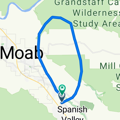
Moab through Arches and Back
Eine Fahrradroute, die in Moab, Utah, Vereinigte Staaten beginnt.
Übersicht
Über diese Route
Dies ist einfach eine der besten Straßenradtouren der Welt. Bei etwas weniger als 44 Meilen gewinnen und verlieren Sie 3300 Fuß (1000 Meter) durch einen der schönsten Nationalparks Amerikas. Es gibt keinen Radweg, also fahren Sie einfach am Straßenrand und machen Sie die Autofahrer auf sich aufmerksam. Nehmen Sie ausreichend Wasser mit und starten Sie in den Sommermonaten früh. Diese Höhenlage bedeutet, dass Sie auf Temperaturschwankungen im Frühling und Herbst vorbereitet sein müssen. Der Winter könnte ziemlich kalt sein, aber wirklich warme, trockene Tage sind möglich. Es gibt Wasser im Devils Garden, dem höchsten Punkt und am Ende, und es gibt Wasser am Park-Hauptquartier etwa 4 Meilen in die Fahrt. Nehmen Sie den Radweg entlang der Autobahn, wenn Sie den Park verlassen und hineinfahren. Es gibt eine Gebühr für den Eintritt in den Park (nicht sicher, wie hoch sie ist). Wenn Sie ein Besucher sind und ein Fahrrad benötigen, probieren Sie Poison Spider am nördlichen Ende von Moab.
- -:--
- Dauer
- 69,8 km
- Distanz
- 1.017 m
- Aufstieg
- 1.024 m
- Abstieg
- ---
- Ø-Tempo
- ---
- Max. Höhe
Routenqualität
Wegtypen und Untergründe entlang der Route
Wegtypen
Straße
18,9 km
(27 %)
Radweg
11,9 km
(17 %)
Untergründe
Befestigt
69,1 km
(99 %)
Asphalt
67 km
(96 %)
Befestigt (undefiniert)
2,1 km
(3 %)
Undefiniert
0,7 km
(1 %)
Weiter mit Bikemap
Diese Radroute verwenden, bearbeiten oder herunterladen
Du möchtest Moab through Arches and Back fahren oder sie für deine eigene Reise anpassen? Folgendes kannst du mit dieser Bikemap-Route machen:
Gratis Funktionen
- Speichere diese Route als Favorit oder in einer Sammlung
- Kopiere & plane deine eigene Version dieser Route
- Synchronisiere deine Route mit Garmin oder Wahoo
Premium-Funktionen
Kostenlose Testversion für 3 Tage oder einmalige Zahlung. Mehr über Bikemap Premium.
- Navigiere diese Route auf iOS & Android
- Exportiere eine GPX / KML-Datei dieser Route
- Erstelle deinen individuellen Ausdruck (Jetzt kostenlos ausprobieren)
- Lade diese Route für die Offline-Navigation herunter
Entdecke weitere Premium-Funktionen.
Bikemap Premium aktivierenVon unserer Community
Moab: Andere beliebte Routen, die hier beginnen
 Potash Road
- Distanz
- 68,6 km
- Aufstieg
- 685 m
- Abstieg
- 688 m
- Standort
- Moab, Utah, Vereinigte Staaten
 Porcupine Rim Trail
- Distanz
- 22,9 km
- Aufstieg
- 529 m
- Abstieg
- 1.054 m
- Standort
- Moab, Utah, Vereinigte Staaten
 Salt Wash-DAV
- Distanz
- 11,9 km
- Aufstieg
- 469 m
- Abstieg
- 356 m
- Standort
- Moab, Utah, Vereinigte Staaten
 Moab
Moab- Distanz
- 17,3 km
- Aufstieg
- 691 m
- Abstieg
- 708 m
- Standort
- Moab, Utah, Vereinigte Staaten
 Moab through Arches and Back
- Distanz
- 69,8 km
- Aufstieg
- 1.017 m
- Abstieg
- 1.024 m
- Standort
- Moab, Utah, Vereinigte Staaten
 Moab - Runde
- Distanz
- 76,8 km
- Aufstieg
- 1.470 m
- Abstieg
- 1.484 m
- Standort
- Moab, Utah, Vereinigte Staaten
 Moab Gran Fondo Loop
- Distanz
- 94,5 km
- Aufstieg
- 1.824 m
- Abstieg
- 1.675 m
- Standort
- Moab, Utah, Vereinigte Staaten
 Moab 100
- Distanz
- 159,6 km
- Aufstieg
- 957 m
- Abstieg
- 957 m
- Standort
- Moab, Utah, Vereinigte Staaten
In der App öffnen