Nucet Hosman
Eine Fahrradroute, die in Roşia, Judeţul Sibiu, Romania beginnt.
Übersicht
Über diese Route
Traseul porneşte de la ieşirea din satul Nucet spre Săcădate şi urcă spre sud-est pe drumul de pământ. Treci de o stână, urmând culmea dealului, apoi intră în pădure. Drumul coboară, apoi virează spre stânga şi urcă spre vest intrând pe o muchie. Ţine drumul forestier ce trece pe la Piscul Mare (611 m) şi ajungeţi apoi pe o zonă de lizieră. Continuă având în dreapta o păşune în formă de amfiteatru împrejmuită cu gard, până vei întâlni marcajul cruce roşie. Continuă pe el la stânga, spre nord traversând pădurea. La ieşirea din pădure, treci pe lângă un loc de popas amenajat şi continuă pe culmea Dealului Cocoşului coborând constant până în satul Hosman. Ai parcurs acest traseu ? Dacă ai identificat probleme de acces (marcaje lipsă, deteriorate sau insuficient de clare, secțiuni impracticabile etc) sau ai sugestii pentru îmbunătățirea lor, te rugăm să ne scrii pe colineletransilvaniei@gmail.com. Nu uita să iei un punct GPS și câteva fotografii - ne va ajuta să intervenim mai repede pentru a remedia situația.
The route starts just outside the village Nucet, direction Săcădate and climbs to the southeast on a dirt road. Pass by a sheepfold, following the hilltop, then enter the forest. The road descends, then turns to the left and climbs westward into an edge. Keep the forest road going to Piscul Mare (611 m) and then reach a forest side area. Continue to the right of an amphitheater-shaped pasture surrounded by a fence, until until you meet the red cross marking. Continue on it to the left, north across the forest. At the exit of the forest, you pass by a place of rest arranged and continue on the peak of the Cocoş Deal and descend to the village of Hosman.
Did you tried this trail? If you have identified access problems (missing, damaged or insufficiently clear markings, inaccessible sections etc.) or have suggestions for their improvement, please write to us at transylvanianhighlands@gmail.com. Don't forget to take a GPS point and a few photos - it will help us to intervene faster to fix the situation
- -:--
- Dauer
- 12,9 km
- Distanz
- 461 m
- Aufstieg
- 532 m
- Abstieg
- ---
- Ø-Tempo
- 740 m
- Ø-Tempo
Fotos von der Route
Weiter mit Bikemap
Diese Radroute verwenden, bearbeiten oder herunterladen
Du möchtest Nucet Hosman fahren oder sie für deine eigene Reise anpassen? Folgendes kannst du mit dieser Bikemap-Route machen:
Gratis Funktionen
- Speichere diese Route als Favorit oder in einer Sammlung
- Kopiere & plane deine eigene Version dieser Route
- Synchronisiere deine Route mit Garmin oder Wahoo
Premium-Funktionen
Kostenlose Testversion für 3 Tage oder einmalige Zahlung. Mehr über Bikemap Premium.
- Navigiere diese Route auf iOS & Android
- Exportiere eine GPX / KML-Datei dieser Route
- Erstelle deinen individuellen Ausdruck (Jetzt kostenlos ausprobieren)
- Lade diese Route für die Offline-Navigation herunter
Entdecke weitere Premium-Funktionen.
Bikemap Premium aktivierenVon unserer Community
Roşia: Andere beliebte Routen, die hier beginnen
- Cornatel - Rosia - Vurpar - Hosman - Nucet - Cornatel
- Distanz
- 42,1 km
- Aufstieg
- 388 m
- Abstieg
- 387 m
- Standort
- Roşia, Hermannstadt, Rumänien
- test Tara Fagarasului et1
- Distanz
- 159 km
- Aufstieg
- 723 m
- Abstieg
- 729 m
- Standort
- Roşia, Hermannstadt, Rumänien
- Colinele Transilvaniei: Nucet - Fofeldea
- Distanz
- 14,9 km
- Aufstieg
- 592 m
- Abstieg
- 664 m
- Standort
- Roşia, Hermannstadt, Rumänien
- Sibiu 1
- Distanz
- 51,3 km
- Aufstieg
- 469 m
- Abstieg
- 468 m
- Standort
- Roşia, Hermannstadt, Rumänien
- Sibiu - Sighisoara - Fagaras
- Distanz
- 200,5 km
- Aufstieg
- 894 m
- Abstieg
- 944 m
- Standort
- Roşia, Hermannstadt, Rumänien
- Tura Sibiu Rural Hartibaciu
- Distanz
- 61,3 km
- Aufstieg
- 594 m
- Abstieg
- 594 m
- Standort
- Roşia, Hermannstadt, Rumänien
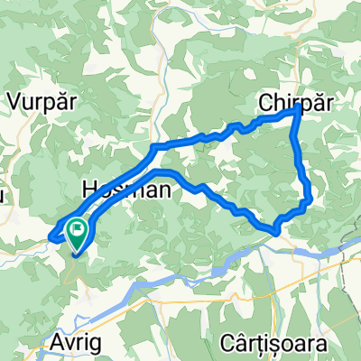
- Cornățel Sheep Route
- Distanz
- 10,2 km
- Aufstieg
- 135 m
- Abstieg
- 129 m
- Standort
- Roşia, Hermannstadt, Rumänien
- DONE_Hartibaciu-padBradu-Avrig-cab Ghiocelul
- Distanz
- 22,6 km
- Aufstieg
- 271 m
- Abstieg
- 121 m
- Standort
- Roşia, Hermannstadt, Rumänien
In der App öffnen