

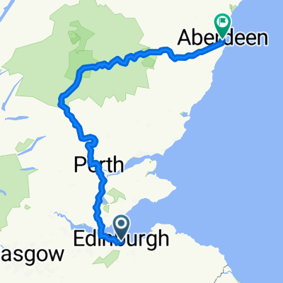
Edinburgh - Blackness Castle via NCN1/76, including new route Hopetoun-Blackness
Eine Fahrradroute, die in Edinburgh, Schottland, Vereinigtes Königreich beginnt.
Übersicht
Über diese Route
There is a new route being officially opened on 20/9/2011 between Hopetoun House & Blackness Castle, along the Forth. The new route is mostly on estate tracks, and most of the sign posts are in place, but not all (yet), and at least one of the gates is still locked on 4/9/2011. Look out for the yellow star markers on the route map I made.
- -:--
- Dauer
- 55,6 km
- Distanz
- 374 m
- Aufstieg
- 374 m
- Abstieg
- ---
- Ø-Tempo
- ---
- Max. Höhe
Highlights der Route
POIs entlang der Route
Interessanter Ort nach 23,9 km
4/9/2011 - gate across path (still) pad-locked; there is a kissing gate for walkers, you can get your bike through vertically at the moment, on its rear wheel.
Interessanter Ort nach 28,3 km
4 Sep 2011 - no sign posts once you leave the wood ... When you arrive at the edge of the wood, go through the gate, across the small wooden bridge and head straight up the grassy slope towards the play ground and St. Ninian's Way. Don't go along the beach as I did, you end up at a set of steps (up and down) and a gate that you have to lift your bike over.
Interessanter Ort nach 31,7 km
a series of hair pin bends, newly constructed, to get up the steep slope towards Abercorn Church (very pretty); the surface is gravel - it was rather loose on 4 Sep., and my tyres (non-slicks!) slipped in a few places ... a solid surface would be a lot safer, especially for inexperienced cyclists (who are looking for a safe off-road route) heading downhill!
Interessanter Ort nach 32 km
Gate
Weiter mit Bikemap
Diese Radroute verwenden, bearbeiten oder herunterladen
Du möchtest Edinburgh - Blackness Castle via NCN1/76, including new route Hopetoun-Blackness fahren oder sie für deine eigene Reise anpassen? Folgendes kannst du mit dieser Bikemap-Route machen:
Gratis Funktionen
- Speichere diese Route als Favorit oder in einer Sammlung
- Kopiere & plane deine eigene Version dieser Route
- Synchronisiere deine Route mit Garmin oder Wahoo
Premium-Funktionen
Kostenlose Testversion für 3 Tage oder einmalige Zahlung. Mehr über Bikemap Premium.
- Navigiere diese Route auf iOS & Android
- Exportiere eine GPX / KML-Datei dieser Route
- Erstelle deinen individuellen Ausdruck (Jetzt kostenlos ausprobieren)
- Lade diese Route für die Offline-Navigation herunter
Entdecke weitere Premium-Funktionen.
Bikemap Premium aktivierenVon unserer Community
Edinburgh: Andere beliebte Routen, die hier beginnen
 westward bound circuit 07/10/17
- Distanz
- 38,9 km
- Aufstieg
- 235 m
- Abstieg
- 241 m
- Standort
- Edinburgh, Schottland, Vereinigtes Königreich
 St Margarets Way - Edinburgh to St Andrews
- Distanz
- 100,1 km
- Aufstieg
- 556 m
- Abstieg
- 644 m
- Standort
- Edinburgh, Schottland, Vereinigtes Königreich
 High Street to Union Street
- Distanz
- 303,9 km
- Aufstieg
- 3.256 m
- Abstieg
- 3.319 m
- Standort
- Edinburgh, Schottland, Vereinigtes Königreich
 106KM Edinburgh
- Distanz
- 107,1 km
- Aufstieg
- 532 m
- Abstieg
- 527 m
- Standort
- Edinburgh, Schottland, Vereinigtes Königreich
 Leamington Terrace, Edinburgh to Leamington Terrace, Edinburgh
- Distanz
- 38,6 km
- Aufstieg
- 423 m
- Abstieg
- 414 m
- Standort
- Edinburgh, Schottland, Vereinigtes Königreich
 Dalkeith Road, Edinburgh to Leamington Walk, Edinburgh
- Distanz
- 37,9 km
- Aufstieg
- 175 m
- Abstieg
- 174 m
- Standort
- Edinburgh, Schottland, Vereinigtes Königreich
 waking up the mumbsculls
- Distanz
- 37,5 km
- Aufstieg
- 208 m
- Abstieg
- 210 m
- Standort
- Edinburgh, Schottland, Vereinigtes Königreich
 Edinburgh - Ormiston - Pathead - Crichton Castle - Arniston - home
- Distanz
- 59,8 km
- Aufstieg
- 419 m
- Abstieg
- 419 m
- Standort
- Edinburgh, Schottland, Vereinigtes Königreich
In der App öffnen