

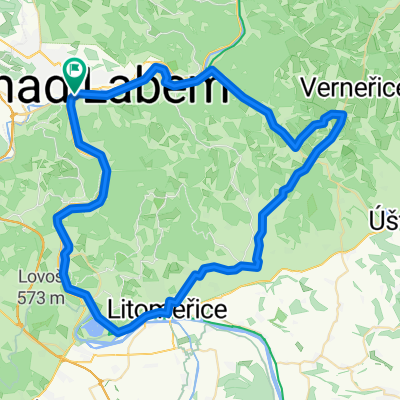
B-D 05. Ústí nad Labem to Mělník
Eine Fahrradroute, die in Aussig, Aussiger Region, Tschechien beginnt.
Übersicht
Über diese Route
Bahnhöfe: Ústí nad Labem; Sebuzin; Libochovany; Velké Žernoseky; Litoměřice Stadt; Steti; Melnik
- -:--
- Dauer
- 73,4 km
- Distanz
- 420 m
- Aufstieg
- 413 m
- Abstieg
- ---
- Ø-Tempo
- 221 m
- Max. Höhe

Routenqualität
Wegtypen und Untergründe entlang der Route
Wegtypen
Radweg
20,5 km
(28 %)
Ruhige Straße
16,9 km
(23 %)
Untergründe
Befestigt
44 km
(60 %)
Unbefestigt
4,4 km
(6 %)
Asphalt
43,3 km
(59 %)
Schotter
2,9 km
(4 %)
Highlights der Route
POIs entlang der Route
Unterkunft nach 0 km
Hotel Větruše
Interessanter Ort nach 2,9 km
Střekov steam water plant The steam water plant was built in 1874 on the occasion of the commissioning of the section of the Austrian North-West Railway from Lysá nad Labem to Ústí nad Labem - Střekov and Děčín. It was used to pump fluid into the water pumps that powered the steam locomotives. Water was brought in from the nearby Elbe River through a specially dug tunnel. The water plant was built according to the design of the architect Carl Schlimp. In the central part there are reservoirs with a volume of 100 m³. There are apartments for employees in the side tracts. It is protected together with the cistern as a cultural monument
Interessanter Ort nach 3,7 km
Hrad Střekov 'Horror' Castle 0930-1730 Ruins of a fortress built in 1316 with a circular tower & an exhibition of weapons, photos & armor.
Interessanter Ort nach 17,7 km
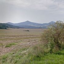
Hradiště Hrádek Iimposing (550 meter long) north-eastern double defensive wall of the castle on Hrádek Hill on the way from Kamýk to Kalvária. The fortification in the eastern part was damaged by agricultural activity and was originally a hundred meters longer. The ramparts were probably built by simply piling up dirt and stones. The trenches were twelve meters wide, and the outer ones were divided at regular intervals by transverse walls, which were supposed to prevent potential attackers from moving freely through the trench. The elevation of the inner rampart above the bottom of the ditch still reaches thirteen meters. The exact dating of the fort is not entirely clear, according to the collections it dates back to the Lusatian culture, Hallstatt and the early Middle Ages (9th and 12th centuries). A few finds also come from the Neolithic, Eneolithic and Late Ages. Hradiště was probably created in the younger Bronze Age. Hradiště, with an area of 21 hectares, is protected in the south and west by the steep slopes of the Elbe valley. The acropolis is considered to be the rocky Kalvárie Hill (separated by a gully from the rest of the hillfort) with a wonderful view of the Gate of Bohemia - Porta Bohemica, where the Elbe River broke through a 140-meter-deep canyon through the České středohoří massif. No remains of fortifications have been preserved around the Calvary, they may have been destroyed during the construction of extensive vineyards.
Interessanter Ort nach 17,9 km
Tři kříže Scenic spot
Interessanter Ort nach 19,4 km
Chateau Grand Žernoseky Velké Žernoseky winery, tastings, good whites!
Interessanter Ort nach 27,2 km
Hrad Litoměřice Castle
Interessanter Ort nach 27,2 km
Litoměřice, Městská památková rezervace historical centre
Interessanter Ort nach 29,7 km
Underground corridors Podzemní chodby Museum
Interessanter Ort nach 29,7 km
Pevnost Terezín Museum guided tours Terezín is a place with a dark past as a Second World War concentration camp. But its history began to be written 150 years earlier, when the purpose of this place was not to serve as a prison, but as a defensive shield against the raids of the Kingdom of Prussia. BASTION FORTS The first bastions, as the element that gave this method of fortification its name, appeared 200 years before Terezín. During all that time, more than a hundred bastion fortresses were built, conquered and defended against conquest around the world. This represents a lot of experience and ideas that the military engineers could use when designing the form of the fortress. THE SHAPE OF THE FORTRESS As it is a purebred fortress built on a green meadow, it could be given an almost perfectly symmetrical and regular shape according to the then most modern principles of fortification. The star-shaped shape therefore does not contain any symbolism or reflect the vanity of the monarch. On the contrary, it is an ingenious and purely expedient defense system composed of a number of elements, each of which has a clearly defined purpose and a precisely designed shape.
Interessanter Ort nach 29,7 km
Wieserův dům
Interessanter Ort nach 30,3 km
Terezin Memorial - Magdeburg Barracks Památník Terezín - Magdeburská kasárna / Ukázka ubikace a umění v ghettu War museum
Interessanter Ort nach 31,4 km
Theresienstadt concentration camp Památník Terezín - Malá pevnost
Interessanter Ort nach 31,8 km
Kleine Festung guided tours
Interessanter Ort nach 32,1 km
Terezín Memorial - The National Cemetery Památník Terezín - Národní hřbitov
Interessanter Ort nach 38,1 km
ferry daily 0900-2000 unless bad weather 25 + 10 CZK kiosk available
Interessanter Ort nach 47,6 km
Roudnice castle Zámek Roudnice
Interessanter Ort nach 65,6 km
Chateau Liběchov Zámek Liběchov
Interessanter Ort nach 72,3 km
Villa Karola and observation points
Interessanter Ort nach 73,4 km
Chateau Melnik Zámek Mělník
Unterkunft nach 73,4 km
Hotel U Rytíře
Interessanter Ort nach 73,4 km
Mělnické podzemí The entrance to the underground is directly from the Mělník Tourist Information Center. The tour is very interesting and the guide is pleasant. The Mělník underground was created from the end of the 13th century. The construction took place simultaneously with the construction of the city. The first floor of the corridor system is located at a depth of 8 to 10 meters below the surface, the third, the deepest, up to 25 meters. Almost every house in the historic center had an underground entrance, so the individual buildings were connected. Today, this is made impossible by frequent backfills and collapses, but also by numerous walls. The place where the well is excavated is pointed out in the pavement of Náměstí Míru by a circular glass plate in a metal frame with an inscription. The 54-meter-deep well was excavated when the city of Mělník was founded and was the only source of drinking water. The depth of the water column is over 7 meters and the diameter of the well is 4.54 meters, making the Mělnice well the widest well in the Czech Republic. You can reach the well through an underground passage from the Tourist Information Center, where group guided tours start. In addition to a well and a replica of a rumpus, there are safe shelter and underground building exhibits underground. Previously, underground spaces were mainly used for food storage and in case of fire or war as a shelter. Several legends and rumors are connected to the Mělnice underground. One of them says that St. Wenceslas sleeps in the bowels of the Mělnice hill and thousands of knights who will come to the aid of the Czech land when the worst comes. Another legend tells of a treasure of immense value, which will only appear if the entire city is reduced to ashes and will serve the citizens to rebuild the burnt city.
Weiter mit Bikemap
Diese Radroute verwenden, bearbeiten oder herunterladen
Du möchtest B-D 05. Ústí nad Labem to Mělník fahren oder sie für deine eigene Reise anpassen? Folgendes kannst du mit dieser Bikemap-Route machen:
Gratis Funktionen
- Speichere diese Route als Favorit oder in einer Sammlung
- Kopiere & plane deine eigene Version dieser Route
- Synchronisiere deine Route mit Garmin oder Wahoo
Premium-Funktionen
Kostenlose Testversion für 3 Tage oder einmalige Zahlung. Mehr über Bikemap Premium.
- Navigiere diese Route auf iOS & Android
- Exportiere eine GPX / KML-Datei dieser Route
- Erstelle deinen individuellen Ausdruck (Jetzt kostenlos ausprobieren)
- Lade diese Route für die Offline-Navigation herunter
Entdecke weitere Premium-Funktionen.
Bikemap Premium aktivierenVon unserer Community
Aussig: Andere beliebte Routen, die hier beginnen
 2017-01
- Distanz
- 30 km
- Aufstieg
- 527 m
- Abstieg
- 471 m
- Standort
- Aussig, Aussiger Region, Tschechien
 2017-05
- Distanz
- 37,2 km
- Aufstieg
- 603 m
- Abstieg
- 604 m
- Standort
- Aussig, Aussiger Region, Tschechien
 Usti - Zdar - Naklerov - Telnice - Usti
- Distanz
- 39,9 km
- Aufstieg
- 759 m
- Abstieg
- 759 m
- Standort
- Aussig, Aussiger Region, Tschechien
 2017-02
- Distanz
- 21,7 km
- Aufstieg
- 461 m
- Abstieg
- 461 m
- Standort
- Aussig, Aussiger Region, Tschechien
 B-D 05. Ústí nad Labem to Mělník
- Distanz
- 73,4 km
- Aufstieg
- 420 m
- Abstieg
- 413 m
- Standort
- Aussig, Aussiger Region, Tschechien
 double single trail
- Distanz
- 39,3 km
- Aufstieg
- 921 m
- Abstieg
- 913 m
- Standort
- Aussig, Aussiger Region, Tschechien
 Rozhledna Náčkovice
- Distanz
- 67,4 km
- Aufstieg
- 618 m
- Abstieg
- 620 m
- Standort
- Aussig, Aussiger Region, Tschechien
 LABSKÁ - Dessau-Ústí
- Distanz
- 343,4 km
- Aufstieg
- 231 m
- Abstieg
- 318 m
- Standort
- Aussig, Aussiger Region, Tschechien
In der App öffnen