

Expressway - Brighton - Marino - hallet Cove - Sheidow Park
Eine Fahrradroute, die in Reynella, Südaustralien, Australien beginnt.
Übersicht
Über diese Route
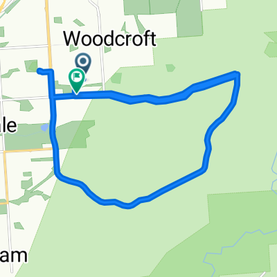
Treten Sie in den Expressway-Veloweg an der Young Street ein, fahren Sie bis zum Ende dieser Strecke, überqueren Sie die Marion Road und schließen Sie sich einem Radweg namens River Sturt Linear Park Track an, folgen Sie diesem Weg in nördlicher Richtung in Richtung Oaklands Park. Am Oaklands Park fahren Sie für eine kurze Strecke auf der Murray Terrace. Treten Sie kurz wieder auf den Radweg, bevor Sie entlang der Addison Road in Richtung Küste fahren. Biegen Sie in die Brighton Road ein, wenden Sie sich in die Jetty Road und nehmen Sie die Esplanade bis zur Wheatland Street. Fahren Sie entlang der Kauri Parade, schließen Sie sich der Newland Avenue an und weiter zur Cove Road in Marino. Fahren Sie entlang des Coast to Vines-Radwegs, folgen Sie diesem Weg durch Hallett Cove, durch Sheidow Park, entlang der Panalatinga Road und verlassen Sie ihn an der States Road, bevor Sie zum Geschäft zurückkehren.
- -:--
- Dauer
- 32,2 km
- Distanz
- 333 m
- Aufstieg
- 333 m
- Abstieg
- ---
- Ø-Tempo
- ---
- Max. Höhe
Weiter mit Bikemap
Diese Radroute verwenden, bearbeiten oder herunterladen
Du möchtest Expressway - Brighton - Marino - hallet Cove - Sheidow Park fahren oder sie für deine eigene Reise anpassen? Folgendes kannst du mit dieser Bikemap-Route machen:
Gratis Funktionen
- Speichere diese Route als Favorit oder in einer Sammlung
- Kopiere & plane deine eigene Version dieser Route
- Synchronisiere deine Route mit Garmin oder Wahoo
Premium-Funktionen
Kostenlose Testversion für 3 Tage oder einmalige Zahlung. Mehr über Bikemap Premium.
- Navigiere diese Route auf iOS & Android
- Exportiere eine GPX / KML-Datei dieser Route
- Erstelle deinen individuellen Ausdruck (Jetzt kostenlos ausprobieren)
- Lade diese Route für die Offline-Navigation herunter
Entdecke weitere Premium-Funktionen.
Bikemap Premium aktivierenVon unserer Community
Reynella: Andere beliebte Routen, die hier beginnen
 Tailwind Cox Hill Route
- Distanz
- 36,1 km
- Aufstieg
- 512 m
- Abstieg
- 512 m
- Standort
- Reynella, Südaustralien, Australien
 humpty route
- Distanz
- 32,1 km
- Aufstieg
- 462 m
- Abstieg
- 462 m
- Standort
- Reynella, Südaustralien, Australien
 Bains road Hill practice double loop
- Distanz
- 31 km
- Aufstieg
- 427 m
- Abstieg
- 431 m
- Standort
- Reynella, Südaustralien, Australien
 Tailwind 3 -Cox's Hill, Clarendon, Main Road, Manning Route - Fast
- Distanz
- 36,4 km
- Aufstieg
- 475 m
- Abstieg
- 475 m
- Standort
- Reynella, Südaustralien, Australien
 Bains & coxs Hill Training (hills) Loop
- Distanz
- 22 km
- Aufstieg
- 472 m
- Abstieg
- 475 m
- Standort
- Reynella, Südaustralien, Australien
 Tailwind Reynell, Main & Bains Route
- Distanz
- 29 km
- Aufstieg
- 348 m
- Abstieg
- 351 m
- Standort
- Reynella, Südaustralien, Australien
 Expressway - Brighton - Marino - hallet Cove - Sheidow Park
- Distanz
- 32,2 km
- Aufstieg
- 333 m
- Abstieg
- 333 m
- Standort
- Reynella, Südaustralien, Australien
 Tailwind 2 -Expressway/Cove Road Route fast group
- Distanz
- 27,9 km
- Aufstieg
- 360 m
- Abstieg
- 360 m
- Standort
- Reynella, Südaustralien, Australien
In der App öffnen