
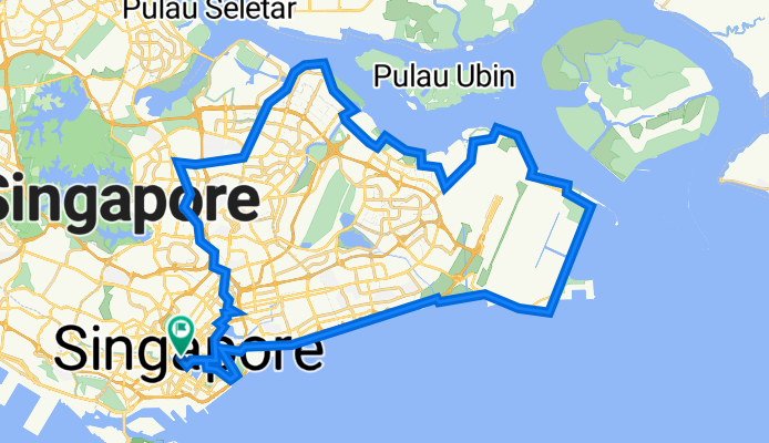
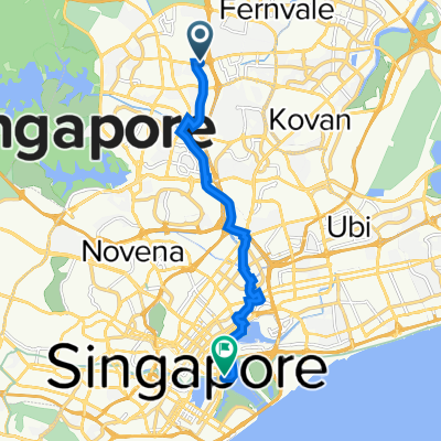
High Street - Kallang - PotongPasir - Bishan - YCK - Punggol - Pasir Ris - TMCR - ECP - Reservoir - High street
Eine Fahrradroute, die in Singapur, Central Singapore Community Development Council, Singapur beginnt.
Übersicht
Über diese Route
- -:--
- Dauer
- 78,6 km
- Distanz
- 487 m
- Aufstieg
- 487 m
- Abstieg
- ---
- Ø-Tempo
- 35 m
- Max. Höhe

Highlights der Route
POIs entlang der Route
Trinkwasser nach 31,3 km
Waypoint 1 - Changi Bay Rest Point & Toilet Break
Foto nach 31,9 km
Welcome to the SG Jeju! Photo Opportunity!!
Foto nach 36,3 km
Waypoint 2 - Changi Beach Park Photo Opportunity & Toilet Break before heading for Dinner
Interessanter Ort nach 36,8 km
DINNER AT CHANGI!!
Trinkwasser nach 52,9 km
Waypoint 3 - Punggol Point Park Rest Point and Photo Opportunity
Trinkwasser nach 74 km
Waypoint 4 - Rest Point and Photo Opportunity!!
Weiter mit Bikemap
Diese Radroute verwenden, bearbeiten oder herunterladen
Du möchtest High Street - Kallang - PotongPasir - Bishan - YCK - Punggol - Pasir Ris - TMCR - ECP - Reservoir - High street fahren oder sie für deine eigene Reise anpassen? Folgendes kannst du mit dieser Bikemap-Route machen:
Gratis Funktionen
- Speichere diese Route als Favorit oder in einer Sammlung
- Kopiere & plane deine eigene Version dieser Route
- Synchronisiere deine Route mit Garmin oder Wahoo
Premium-Funktionen
Kostenlose Testversion für 3 Tage oder einmalige Zahlung. Mehr über Bikemap Premium.
- Navigiere diese Route auf iOS & Android
- Exportiere eine GPX / KML-Datei dieser Route
- Erstelle deinen individuellen Ausdruck (Jetzt kostenlos ausprobieren)
- Lade diese Route für die Offline-Navigation herunter
Entdecke weitere Premium-Funktionen.
Bikemap Premium aktivierenVon unserer Community
Singapur: Andere beliebte Routen, die hier beginnen
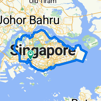
 Round the Island
- Distanz
- 130,5 km
- Aufstieg
- 171 m
- Abstieg
- 174 m
- Standort
- Singapur, Central Singapore Community Development Council, Singapur
 Punggol Rd, Singapore to Helix Bridge, Singapore
- Distanz
- 17,8 km
- Aufstieg
- 245 m
- Abstieg
- 251 m
- Standort
- Singapur, Central Singapore Community Development Council, Singapur
 Punggol East, Singapore to Kallang, Singapore
- Distanz
- 49,6 km
- Aufstieg
- 125 m
- Abstieg
- 130 m
- Standort
- Singapur, Central Singapore Community Development Council, Singapur
 Half of SG
- Distanz
- 89,8 km
- Aufstieg
- 169 m
- Abstieg
- 173 m
- Standort
- Singapur, Central Singapore Community Development Council, Singapur
 NINTENDO ISLAND TOUR - AMENDED 2
- Distanz
- 75,3 km
- Aufstieg
- 129 m
- Abstieg
- 135 m
- Standort
- Singapur, Central Singapore Community Development Council, Singapur
 Singapore PCN Cycle Loop
- Distanz
- 143,4 km
- Aufstieg
- 556 m
- Abstieg
- 538 m
- Standort
- Singapur, Central Singapore Community Development Council, Singapur
 AMK ITE TO MBS
- Distanz
- 13,6 km
- Aufstieg
- 93 m
- Abstieg
- 117 m
- Standort
- Singapur, Central Singapore Community Development Council, Singapur
 Junction 10 - Pang Sua - Bollywood - Lim Chu Kang - Old Chua Chu Kang
- Distanz
- 31,3 km
- Aufstieg
- 246 m
- Abstieg
- 246 m
- Standort
- Singapur, Central Singapore Community Development Council, Singapur
In der App öffnen