

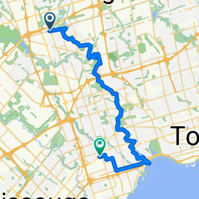
bike route from 2757 to Kipling subway station
Eine Fahrradroute, die in Concord, Ontario, Kanada beginnt.
Übersicht
Über diese Route
I did not official ride on this route. However what I did yesterday I chose to bike ride for 15 minites to my nearest grocery store on a busy hour to see how accessible or accomodating it it for bikers. to my oberservation the ride was really scarry and intense because i was riding the bike with pedestrian and cars. most times i really had to slow down because pedestrians used the bike lane to walk on. i was also sharing the road with mothers pushing they babies in strollers and people with accible needs. the other issue that happened was when to cross the road, even if it was my turn or right of way it was difficult for drivers to observe that, that most i hand signal them to go and then i proceeded with my ride.
- -:--
- Dauer
- 16,1 km
- Distanz
- 84 m
- Aufstieg
- 116 m
- Abstieg
- ---
- Ø-Tempo
- 167 m
- Max. Höhe
Routenqualität
Wegtypen und Untergründe entlang der Route
Wegtypen
Ruhige Straße
7,7 km
(48 %)
Vielbefahrene Straße
3,5 km
(22 %)
Untergründe
Befestigt
14,5 km
(90 %)
Asphalt
13,2 km
(82 %)
Beton
1,3 km
(8 %)
Undefiniert
1,6 km
(10 %)
Weiter mit Bikemap
Diese Radroute verwenden, bearbeiten oder herunterladen
Du möchtest bike route from 2757 to Kipling subway station fahren oder sie für deine eigene Reise anpassen? Folgendes kannst du mit dieser Bikemap-Route machen:
Gratis Funktionen
- Speichere diese Route als Favorit oder in einer Sammlung
- Kopiere & plane deine eigene Version dieser Route
- Synchronisiere deine Route mit Garmin oder Wahoo
Premium-Funktionen
Kostenlose Testversion für 3 Tage oder einmalige Zahlung. Mehr über Bikemap Premium.
- Navigiere diese Route auf iOS & Android
- Exportiere eine GPX / KML-Datei dieser Route
- Erstelle deinen individuellen Ausdruck (Jetzt kostenlos ausprobieren)
- Lade diese Route für die Offline-Navigation herunter
Entdecke weitere Premium-Funktionen.
Bikemap Premium aktivierenVon unserer Community
Concord: Andere beliebte Routen, die hier beginnen
 humber river
- Distanz
- 37,1 km
- Aufstieg
- 397 m
- Abstieg
- 455 m
- Standort
- Concord, Ontario, Kanada
 Humber Recreational Trail
- Distanz
- 24,5 km
- Aufstieg
- 73 m
- Abstieg
- 143 m
- Standort
- Concord, Ontario, Kanada
 Vaughan to Downsview Park Via Maple, BS Greenway, G Ross Lord, Earl Bales
- Distanz
- 49,4 km
- Aufstieg
- 204 m
- Abstieg
- 210 m
- Standort
- Concord, Ontario, Kanada
 Lake Wilcox Vishnu Mandir
- Distanz
- 64,3 km
- Aufstieg
- 430 m
- Abstieg
- 432 m
- Standort
- Concord, Ontario, Kanada
 Downsview Park to Claireville Ranch and BAPS
- Distanz
- 50,2 km
- Aufstieg
- 306 m
- Abstieg
- 307 m
- Standort
- Concord, Ontario, Kanada
 Vaughan station to Kortright conservation park
- Distanz
- 31,1 km
- Aufstieg
- 475 m
- Abstieg
- 475 m
- Standort
- Concord, Ontario, Kanada
 De Shoreham Drive 30, Toronto a Martin Goodman Trail, Toronto
- Distanz
- 27,3 km
- Aufstieg
- 260 m
- Abstieg
- 369 m
- Standort
- Concord, Ontario, Kanada
 Downsview Station to High Park Zoo Via West Humber, Etobicoke Creek, Centennial Park, Duck Pond
- Distanz
- 60,4 km
- Aufstieg
- 354 m
- Abstieg
- 432 m
- Standort
- Concord, Ontario, Kanada
In der App öffnen