

Cycles Bespoke Ride
Eine Fahrradroute, die in Embleton, Western Australia, Australia beginnt.
Übersicht
Über diese Route
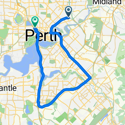
Usually a 6:30 Saturday morning ride from Bayswater Train Station car park, 70 km up into the hills and back, but feel free to do it any time.
Follow the bike path under Tonkin Highway and (carefully) join Guildford Rd at the traffic lights.
It's a flat ride out past Midland, then a hard climb up through Helena Valley. Cross Gt Eastern Highway into John Forrest National Park; the entry and exit boom gates are often down but you can walk around them. There's a pleasant meander through the bush but watch out for marri nuts dropped onto the road by cockatoos.
Watch out for the sharp right turn as you meet Victoria Rd as you drop down to Jane Brook; then another steep climb up Oxley Rd in Mahogany Creek. After crossing Mundaring, a long descent back to Helena Valley with some short climbs.
Watch out for the steep descent and right turn at Leith Rd, with a quick plummet and rise to a sharp left onto Glen Rd. Close ahead are two other tight right hand bends on Victor Rd.
You will soon meet your outward route and follow it back to Bayswater Train Station. (The fine gentlemen of Cycles Bespoke are on the opposite corner.)
- -:--
- Dauer
- 69,7 km
- Distanz
- 500 m
- Aufstieg
- 500 m
- Abstieg
- ---
- Ø-Tempo
- ---
- Ø-Tempo

Routenqualität
Wegtypen und Untergründe entlang der Route
Wegtypen
Vielbefahrene Straße
17,2 km
(25 %)
Straße
16,8 km
(24 %)
Untergründe
Befestigt
55,4 km
(80 %)
Asphalt
34 km
(49 %)
Befestigt (undefiniert)
20,8 km
(30 %)
Weiter mit Bikemap
Diese Radroute verwenden, bearbeiten oder herunterladen
Du möchtest Cycles Bespoke Ride fahren oder sie für deine eigene Reise anpassen? Folgendes kannst du mit dieser Bikemap-Route machen:
Gratis Funktionen
- Speichere diese Route als Favorit oder in einer Sammlung
- Kopiere & plane deine eigene Version dieser Route
- Synchronisiere deine Route mit Garmin oder Wahoo
Premium-Funktionen
Kostenlose Testversion für 3 Tage oder einmalige Zahlung. Mehr über Bikemap Premium.
- Navigiere diese Route auf iOS & Android
- Exportiere eine GPX / KML-Datei dieser Route
- Erstelle deinen individuellen Ausdruck (Jetzt kostenlos ausprobieren)
- Lade diese Route für die Offline-Navigation herunter
Entdecke weitere Premium-Funktionen.
Bikemap Premium aktivierenVon unserer Community
Embleton: Andere beliebte Routen, die hier beginnen
 52 Slade St, Bayswater to 135 Whatley Cr, Bayswater
- Distanz
- 130,8 km
- Aufstieg
- 932 m
- Abstieg
- 927 m
- Standort
- Embleton, Western Australia, Australien
 Cycles Bespoke Ride
- Distanz
- 69,7 km
- Aufstieg
- 500 m
- Abstieg
- 500 m
- Standort
- Embleton, Western Australia, Australien
 bayswater langford leederville
- Distanz
- 50,1 km
- Aufstieg
- 150 m
- Abstieg
- 158 m
- Standort
- Embleton, Western Australia, Australien
 243 Beechboro Rd N, Embleton to 45 Norman St, Innaloo
- Distanz
- 19,9 km
- Aufstieg
- 325 m
- Abstieg
- 326 m
- Standort
- Embleton, Western Australia, Australien
 Audax Dawn to Dusk Winter
- Distanz
- 203,8 km
- Aufstieg
- 863 m
- Abstieg
- 863 m
- Standort
- Embleton, Western Australia, Australien
 7 Deschamp Rd, Noranda to 198–208 Whatley Cr, Maylands
- Distanz
- 9,4 km
- Aufstieg
- 41 m
- Abstieg
- 52 m
- Standort
- Embleton, Western Australia, Australien
 Bayswater Station to Woodside
- Distanz
- 9,8 km
- Aufstieg
- 44 m
- Abstieg
- 49 m
- Standort
- Embleton, Western Australia, Australien
 Recovered Route
- Distanz
- 299,2 km
- Aufstieg
- 2.011 m
- Abstieg
- 2.021 m
- Standort
- Embleton, Western Australia, Australien
In der App öffnen