solo France 2 weeks
- 1.172,3 km
- 6.153 m
- 6.142 m
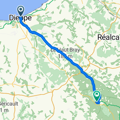
- Dieppe, Normandie, Frankreich
Eine Fahrradroute, die in Dieppe, Normandie, Frankreich beginnt.
Übersicht
Die Strecke ist ab dem Verlassen des DFDS-Fährterminals deutlich ausgeschildert, obwohl die GPX-Anweisungen an einigen Stellen in den Stadtstraßen davon abweichen können, bevor der eigentliche Beginn von L'Avenue Verte erreicht wird.
Der Rest der Tagesetappe folgt der ehemaligen Bahntrasse. Steigungen sind gering und der Belag ist glatter Asphalt. Vorsicht ist geboten an Straßenquerungen an Stellen, an denen früher Bahnübergänge waren. Diese Stellen sind heute noch an den ehemaligen Wohnhäusern der Männer zu erkennen, die dafür verantwortlich waren, die Schranken zu heben und zu senken.
Ruhe- und Einkehrmöglichkeiten bieten Picknicktische und hin und wieder Restaurants. Kleine Abstecher in nahegelegene Dörfer bieten zusätzliche Gelegenheiten zum Sightseeing.
Der Tag endet in Forges-les-Eaux, wo es mehrere Hotels, Restaurants, Bars und Cafés gibt, die Radfahrer willkommen heißen.
Erstellt vor 2 Jahren


Routenqualität
Pfad
46,6 km
(82 %)
Ruhige Straße
4 km
(7 %)
Befestigt
54 km
(95 %)
Asphalt
52,3 km
(92 %)
Befestigt (undefiniert)
1,1 km
(2 %)
Weiter mit Bikemap
Du möchtest 01 Day 1, Dieppe - Forges-les-Eaux fahren oder sie für deine eigene Reise anpassen? Folgendes kannst du mit dieser Bikemap-Route machen:
Kostenlose Testversion für 3 Tage oder einmalige Zahlung. Mehr über Bikemap Premium.
Entdecke weitere Premium-Funktionen.
Bikemap Premium aktivierenVon unserer Community
In der App öffnen