

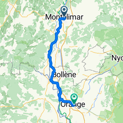
Montélimar to Fournès
Eine Fahrradroute, die in Montélimar, Auvergne-Rhône-Alpes, France beginnt.
Übersicht
Über diese Route
The first fifty or so kilometers of this ride were outstanding low traffic roads and cycling path, much of that being along the ViaRhôna, which had some paved and some hard-pack dirt sections. In also included some very low-traffic roads. Overall, the ViaRhôna was a great find.
From Pont-Saint-Esprit, there was a cycling route (not part of the ViaRhôna) on some really quiet country roads that we took until the cycling route took a turn away from our intended direction. At that point, we took small roads to St-Nazaire, where we had a snack before beginning to pedal on N86/D6086, which took us a little over 30 kilometers to Remoulins, where we did some shopping at a Carrefour.
While all of the riding up to our arrival in St-Nazaire was simply outstanding, things riding-wise went downhill once we were on N86/D6086. There was too much traffic and what little road shoulder there was was often measured in inches rather than in feet. Fortunately, during the lengthy climb on that section, there was a little more shoulder.
We advise any interested person to try to avoid riding on this portino of N86/D6086. Find smaller roads if possible.
- 7 h 7 min
- Dauer
- 87,4 km
- Distanz
- 654 m
- Aufstieg
- 674 m
- Abstieg
- 12,3 km/h
- Ø-Tempo
- 237 m
- Ø-Tempo

Fotos von der Route


Routenqualität
Wegtypen und Untergründe entlang der Route
Wegtypen
Vielbefahrene Straße
34,9 km
(40 %)
Ruhige Straße
28,7 km
(33 %)
Untergründe
Befestigt
51 km
(58 %)
Unbefestigt
0,4 km
(<1 %)
Asphalt
49,4 km
(57 %)
Beton
1,5 km
(2 %)
Weiter mit Bikemap
Diese Radroute verwenden, bearbeiten oder herunterladen
Du möchtest Montélimar to Fournès fahren oder sie für deine eigene Reise anpassen? Folgendes kannst du mit dieser Bikemap-Route machen:
Gratis Funktionen
- Speichere diese Route als Favorit oder in einer Sammlung
- Kopiere & plane deine eigene Version dieser Route
- Synchronisiere deine Route mit Garmin oder Wahoo
Premium-Funktionen
Kostenlose Testversion für 3 Tage oder einmalige Zahlung. Mehr über Bikemap Premium.
- Navigiere diese Route auf iOS & Android
- Exportiere eine GPX / KML-Datei dieser Route
- Erstelle deinen individuellen Ausdruck (Jetzt kostenlos ausprobieren)
- Lade diese Route für die Offline-Navigation herunter
Entdecke weitere Premium-Funktionen.
Bikemap Premium aktivierenVon unserer Community
Montélimar: Andere beliebte Routen, die hier beginnen
 V-4. Montelimar - Orange
- Distanz
- 72,1 km
- Aufstieg
- 187 m
- Abstieg
- 225 m
- Standort
- Montélimar, Auvergne-Rhône-Alpes, Frankreich
 The Demi Ardèche-Cévennes Divide
- Distanz
- 218,4 km
- Aufstieg
- 5.962 m
- Abstieg
- 5.905 m
- Standort
- Montélimar, Auvergne-Rhône-Alpes, Frankreich
 Montelimar - Mont Ventoux
- Distanz
- 153,9 km
- Aufstieg
- 1.895 m
- Abstieg
- 83 m
- Standort
- Montélimar, Auvergne-Rhône-Alpes, Frankreich
 Aleyrac
- Distanz
- 63,2 km
- Aufstieg
- 791 m
- Abstieg
- 791 m
- Standort
- Montélimar, Auvergne-Rhône-Alpes, Frankreich
 2016 Ride Day 97 - Montélimar Circle to East
- Distanz
- 64,8 km
- Aufstieg
- 548 m
- Abstieg
- 548 m
- Standort
- Montélimar, Auvergne-Rhône-Alpes, Frankreich
 2016 Ride Day 98 - Montélimar to Vesc
- Distanz
- 42,6 km
- Aufstieg
- 613 m
- Abstieg
- 101 m
- Standort
- Montélimar, Auvergne-Rhône-Alpes, Frankreich
 6- Montélimar - Roquemaure
- Distanz
- 76,6 km
- Aufstieg
- 12 m
- Abstieg
- 64 m
- Standort
- Montélimar, Auvergne-Rhône-Alpes, Frankreich
 13. Tag Saint Julien du Gua - Saint Nazaire en Royans
- Distanz
- 103,8 km
- Aufstieg
- 219 m
- Abstieg
- 132 m
- Standort
- Montélimar, Auvergne-Rhône-Alpes, Frankreich
In der App öffnen