

SDJM Loop
Eine Fahrradroute, die in San Jose del Monte City, Central Luzon, Philippinen beginnt.
Übersicht
Über diese Route
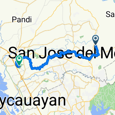
Startpunkt: Grotto Vista Resort - 7Eleven
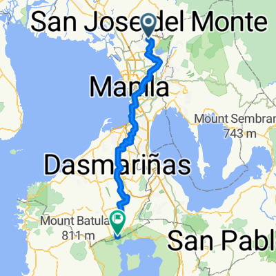
Endpunkt: Altaraza Central Park
Routen:
- GVR zum Tanawin View Deck über Tungko
- Tanawin View Deck zum Abfahrt von Paradise Drive
- Rechts abbiegen zum Liana Rd (Anstieg)
- Links abbiegen an der T-Kreuzung von Liana Rd, dann nochmal links zur Skyline Road
- Rechts abbiegen an der Hauptstraße und weiter zu Road 2 (geradeaus auf der Hauptstraße)
- Links abbiegen bei Road 2 und geradeaus fahren bis Sapang Palay (Anstieg)
- Links abbiegen bei Matiyaga Street. Orientierungspunkte: Iglesia ni Cristo Kirche rechts, Brgy. Bagong Buhay II Torbogen links
- Rechts abbiegen in die Maginhawa Street und links an der T-Kreuzung/Hauptstraße
- Links abbiegen an der nächsten T-Kreuzung/Bagong Buhay Ave.
- Rechts abbiegen in die Sta. Maria-San Jose Rd., dann links in die Linawin Street
- Geradeaus bis Muzon, dann links bis Kaypian Rd und rechts abbiegen
- Geradeaus auf Kaypian Rd, rechts auf die Hauptstraße und dann rechts auf Gumaok Rd.
- Bei San Jose Kirche links auf Daang Barrion Rd, dann links an der Kreuzung der Hauptstraße (Richtung Tungkong Mangga)
- Schließlich geradeaus zum Tungko-Kreuzung, Qualimed Hospital und Eingang von Altaraza Place, eine Runde um Altaraza drehen und die Fahrt am Altaraza Central Park beenden.
- -:--
- Dauer
- 50,5 km
- Distanz
- 667 m
- Aufstieg
- 660 m
- Abstieg
- ---
- Ø-Tempo
- 161 m
- Max. Höhe

Routenqualität
Wegtypen und Untergründe entlang der Route
Wegtypen
Straße
16,2 km
(32 %)
Ruhige Straße
3,5 km
(7 %)
Untergründe
Befestigt
24,8 km
(49 %)
Beton
15,2 km
(30 %)
Asphalt
9,6 km
(19 %)
Undefiniert
25,8 km
(51 %)
Weiter mit Bikemap
Diese Radroute verwenden, bearbeiten oder herunterladen
Du möchtest SDJM Loop fahren oder sie für deine eigene Reise anpassen? Folgendes kannst du mit dieser Bikemap-Route machen:
Gratis Funktionen
- Speichere diese Route als Favorit oder in einer Sammlung
- Kopiere & plane deine eigene Version dieser Route
- Synchronisiere deine Route mit Garmin oder Wahoo
Premium-Funktionen
Kostenlose Testversion für 3 Tage oder einmalige Zahlung. Mehr über Bikemap Premium.
- Navigiere diese Route auf iOS & Android
- Exportiere eine GPX / KML-Datei dieser Route
- Erstelle deinen individuellen Ausdruck (Jetzt kostenlos ausprobieren)
- Lade diese Route für die Offline-Navigation herunter
Entdecke weitere Premium-Funktionen.
Bikemap Premium aktivierenVon unserer Community
San Jose del Monte City: Andere beliebte Routen, die hier beginnen
 Arena
Arena- Distanz
- 27,5 km
- Aufstieg
- 227 m
- Abstieg
- 287 m
- Standort
- San Jose del Monte City, Central Luzon, Philippinen
 di planadong gala
- Distanz
- 79,5 km
- Aufstieg
- 682 m
- Abstieg
- 665 m
- Standort
- San Jose del Monte City, Central Luzon, Philippinen
 San Jose Del Monte City to San Jose Del Monte City
- Distanz
- 9,6 km
- Aufstieg
- 127 m
- Abstieg
- 127 m
- Standort
- San Jose del Monte City, Central Luzon, Philippinen
 Easy ride in Marilao
- Distanz
- 17 km
- Aufstieg
- 77 m
- Abstieg
- 151 m
- Standort
- San Jose del Monte City, Central Luzon, Philippinen
 Azalea 6735, North Caloocan to Unnamed Road, General Trias
- Distanz
- 56,6 km
- Aufstieg
- 225 m
- Abstieg
- 263 m
- Standort
- San Jose del Monte City, Central Luzon, Philippinen
 San Jose del Monte City to San Jose del Monte City
- Distanz
- 40,9 km
- Aufstieg
- 358 m
- Abstieg
- 350 m
- Standort
- San Jose del Monte City, Central Luzon, Philippinen
 San Jose Del Monte City to San Jose Del Monte City
- Distanz
- 6,4 km
- Aufstieg
- 79 m
- Abstieg
- 75 m
- Standort
- San Jose del Monte City, Central Luzon, Philippinen
 Route from Petunia
- Distanz
- 118,2 km
- Aufstieg
- 1.020 m
- Abstieg
- 416 m
- Standort
- San Jose del Monte City, Central Luzon, Philippinen
In der App öffnen