

Camel Trail Circuit with a ferry
Eine Fahrradroute, die in Wadebridge, England, United Kingdom beginnt.
Übersicht
Über diese Route
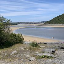
Mixture of the entire length of the Camel Trail (17 miles) where the surface is compacted china clay and grit, flat all the way and suitable for all (except maybe racing bikes) and then a hilly section on lanes, all paved.
Easiest to do this clockwise as the hill from Poolys Bridge (end of Camel trail) to St Tudy is 2 miles up hill. (or down if done clockwise!)
Lots of pubs and tea rooms on route
Good old traditional English pubs at St Tudy, Chapel Amble and St Kew
Parking at Padstow, Wadebridge, Dunmere, Helland Brdge. Bike hire at Wadebridge and Padstow
Padstow/Rock ferry bikes cost £1, runs every 15 mins during the summer, a bit less in the winter. daylight hours.
- -:--
- Dauer
- 51,1 km
- Distanz
- 365 m
- Aufstieg
- 365 m
- Abstieg
- ---
- Ø-Tempo
- ---
- Ø-Tempo
Weiter mit Bikemap
Diese Radroute verwenden, bearbeiten oder herunterladen
Du möchtest Camel Trail Circuit with a ferry fahren oder sie für deine eigene Reise anpassen? Folgendes kannst du mit dieser Bikemap-Route machen:
Gratis Funktionen
- Speichere diese Route als Favorit oder in einer Sammlung
- Kopiere & plane deine eigene Version dieser Route
- Synchronisiere deine Route mit Garmin oder Wahoo
Premium-Funktionen
Kostenlose Testversion für 3 Tage oder einmalige Zahlung. Mehr über Bikemap Premium.
- Navigiere diese Route auf iOS & Android
- Exportiere eine GPX / KML-Datei dieser Route
- Erstelle deinen individuellen Ausdruck (Jetzt kostenlos ausprobieren)
- Lade diese Route für die Offline-Navigation herunter
Entdecke weitere Premium-Funktionen.
Bikemap Premium aktivierenVon unserer Community
Wadebridge: Andere beliebte Routen, die hier beginnen
 Wadebridge Cycling
- Distanz
- 56,7 km
- Aufstieg
- 916 m
- Abstieg
- 757 m
- Standort
- Wadebridge, England, Vereinigtes Königreich
 Wadebridge to Crediton
- Distanz
- 102,7 km
- Aufstieg
- 768 m
- Abstieg
- 710 m
- Standort
- Wadebridge, England, Vereinigtes Königreich
 Kingfishers Rest, Eddystone Road, Wadebridge to The Cave, Mill Road, Padstow
- Distanz
- 9,6 km
- Aufstieg
- 0 m
- Abstieg
- 3 m
- Standort
- Wadebridge, England, Vereinigtes Königreich
 End to End - Day 02
- Distanz
- 167,7 km
- Aufstieg
- 2.175 m
- Abstieg
- 2.160 m
- Standort
- Wadebridge, England, Vereinigtes Königreich
 half way back
- Distanz
- 6,7 km
- Aufstieg
- 93 m
- Abstieg
- 99 m
- Standort
- Wadebridge, England, Vereinigtes Königreich
 Molesworth Street 12 to Quay Road, Saint Germans
- Distanz
- 48,8 km
- Aufstieg
- 765 m
- Abstieg
- 742 m
- Standort
- Wadebridge, England, Vereinigtes Königreich
 Wadebridge to The Borough Arms, Dunmere
- Distanz
- 8,6 km
- Aufstieg
- 110 m
- Abstieg
- 147 m
- Standort
- Wadebridge, England, Vereinigtes Königreich
 LEJOG Day 2 Wadebridge to Tiverton
- Distanz
- 168 km
- Aufstieg
- 903 m
- Abstieg
- 939 m
- Standort
- Wadebridge, England, Vereinigtes Königreich
In der App öffnen