

TT - Chelveston NC10/27 10 Mile
Eine Fahrradroute, die in Higham Ferrers, England, Vereinigtes Königreich beginnt.
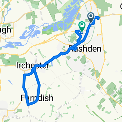
Übersicht
Über diese Route
- Starten Sie auf der Caldecott- nach Newton Bromswold-Straße, im Tor gegenüber der Newton Road-Abzweigung, Grid Ref, SP 994 670 GB. Fahren Sie weiter entlang der Straße, biegen Sie nicht ab, bis Sie den A6-Kreisverkehr erreichen.
- Biegen Sie am A6 / Newton Road-Kreisel links (nach Süden) in die A6 Richtung Bedford ab.
- Biegen Sie am A6 / A5028-Kreisverkehr an der dritten Ausfahrt (nach Norden) ab und fahren Sie wieder entlang der A6 zurück.
- Biegen Sie am A6 / Newton Road-Kreisverkehr an der zweiten Ausfahrt weiter auf der A6 (nach Norden) ab.
- Biegen Sie am A6 / John Clark Way-Kreisverkehr an der dritten Ausfahrt (nach Süden) ab und fahren Sie wieder entlang der A6 zurück.
- Biegen Sie am A6 / Newton Road-Kreisverkehr an der ersten Ausfahrt links ab und fahren Sie entlang der Rushden Road Richtung Newton Bromswold.
- Beenden Sie auf der Caldecott- nach Newton Bromswold-Straße, auf einem festen Platz nach der Abzweigung zur Newton Road, Grid Ref, SP 994 670 GB.
- -:--
- Dauer
- 16 km
- Distanz
- 63 m
- Aufstieg
- 62 m
- Abstieg
- ---
- Ø-Tempo
- ---
- Max. Höhe
Routenqualität
Wegtypen und Untergründe entlang der Route
Wegtypen
Straße
9,1 km
(57 %)
Ruhige Straße
3,7 km
(23 %)
Weiter mit Bikemap
Diese Radroute verwenden, bearbeiten oder herunterladen
Du möchtest TT - Chelveston NC10/27 10 Mile fahren oder sie für deine eigene Reise anpassen? Folgendes kannst du mit dieser Bikemap-Route machen:
Gratis Funktionen
- Speichere diese Route als Favorit oder in einer Sammlung
- Kopiere & plane deine eigene Version dieser Route
- Synchronisiere deine Route mit Garmin oder Wahoo
Premium-Funktionen
Kostenlose Testversion für 3 Tage oder einmalige Zahlung. Mehr über Bikemap Premium.
- Navigiere diese Route auf iOS & Android
- Exportiere eine GPX / KML-Datei dieser Route
- Erstelle deinen individuellen Ausdruck (Jetzt kostenlos ausprobieren)
- Lade diese Route für die Offline-Navigation herunter
Entdecke weitere Premium-Funktionen.
Bikemap Premium aktivierenVon unserer Community
Higham Ferrers: Andere beliebte Routen, die hier beginnen
 TT - Chelveston Time Trial
- Distanz
- 16,1 km
- Aufstieg
- 60 m
- Abstieg
- 56 m
- Standort
- Higham Ferrers, England, Vereinigtes Königreich
 TT - Chelveston NC10/27 10 Mile
- Distanz
- 16 km
- Aufstieg
- 63 m
- Abstieg
- 62 m
- Standort
- Higham Ferrers, England, Vereinigtes Königreich
 45RC A6 10TT - NC10/27
- Distanz
- 16,1 km
- Aufstieg
- 59 m
- Abstieg
- 55 m
- Standort
- Higham Ferrers, England, Vereinigtes Königreich
 Larkhill 6 to Larkhill 6
- Distanz
- 39,4 km
- Aufstieg
- 269 m
- Abstieg
- 277 m
- Standort
- Higham Ferrers, England, Vereinigtes Königreich
 Larkhill 6 to Larkhill 6
- Distanz
- 35,5 km
- Aufstieg
- 213 m
- Abstieg
- 219 m
- Standort
- Higham Ferrers, England, Vereinigtes Königreich
 Hills
Hills- Distanz
- 137,2 km
- Aufstieg
- 644 m
- Abstieg
- 643 m
- Standort
- Higham Ferrers, England, Vereinigtes Königreich
 relaxing ride through irchester
- Distanz
- 19,2 km
- Aufstieg
- 164 m
- Abstieg
- 180 m
- Standort
- Higham Ferrers, England, Vereinigtes Königreich
 Larkhill 7 to Larkhill 6
- Distanz
- 0,1 km
- Aufstieg
- 0 m
- Abstieg
- 0 m
- Standort
- Higham Ferrers, England, Vereinigtes Königreich
In der App öffnen