

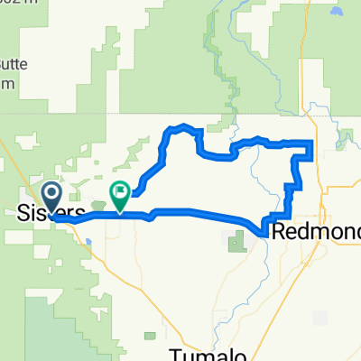
Sisters To Terrabone
Eine Fahrradroute, die in Sisters, Oregon, United States of America beginnt.
Übersicht
Über diese Route
This is a great ride on some backcountry roads with beautiful scenery and some light rollers. Once you get past the first 2 miles on Highway 126, its smooth sailing from there. Head left on 126 from Junipine. Turn left on Goodrich and then right on Goodrich Loop. That turns into Holmes Road and take that all the way to the end. Turn right on Lower Bridge Road and take that all the way to NW 19th Ave. From there, you can turn around and come back, OR turn right on NW 19th and continue out to Smith Rock. This out and back to NW 19th is aproximately 45 miles.
- -:--
- Dauer
- 75,1 km
- Distanz
- 430 m
- Aufstieg
- 431 m
- Abstieg
- ---
- Ø-Tempo
- 963 m
- Ø-Tempo

Routenqualität
Wegtypen und Untergründe entlang der Route
Wegtypen
Straße
69,1 km
(92 %)
Radweg
3,8 km
(5 %)
Untergründe
Befestigt
27,8 km
(37 %)
Unbefestigt
0,6 km
(<1 %)
Asphalt
27,8 km
(37 %)
Unbefestigt (undefiniert)
0,6 km
(<1 %)
Undefiniert
46,6 km
(62 %)
Weiter mit Bikemap
Diese Radroute verwenden, bearbeiten oder herunterladen
Du möchtest Sisters To Terrabone fahren oder sie für deine eigene Reise anpassen? Folgendes kannst du mit dieser Bikemap-Route machen:
Gratis Funktionen
- Speichere diese Route als Favorit oder in einer Sammlung
- Kopiere & plane deine eigene Version dieser Route
- Synchronisiere deine Route mit Garmin oder Wahoo
Premium-Funktionen
Kostenlose Testversion für 3 Tage oder einmalige Zahlung. Mehr über Bikemap Premium.
- Navigiere diese Route auf iOS & Android
- Exportiere eine GPX / KML-Datei dieser Route
- Erstelle deinen individuellen Ausdruck (Jetzt kostenlos ausprobieren)
- Lade diese Route für die Offline-Navigation herunter
Entdecke weitere Premium-Funktionen.
Bikemap Premium aktivierenVon unserer Community
Sisters: Andere beliebte Routen, die hier beginnen
 South Locust Street 889, Sisters to South Fir Street 350, Sisters
- Distanz
- 10,1 km
- Aufstieg
- 164 m
- Abstieg
- 168 m
- Standort
- Sisters, Oregon, USA
 Sisters Cycling
- Distanz
- 23,4 km
- Aufstieg
- 663 m
- Abstieg
- 8 m
- Standort
- Sisters, Oregon, USA
 Sisters to Smith rocks loop
- Distanz
- 74,1 km
- Aufstieg
- 451 m
- Abstieg
- 483 m
- Standort
- Sisters, Oregon, USA
 West Jefferson Avenue 556, Sisters to West Jefferson Avenue 556, Sisters
- Distanz
- 4,7 km
- Aufstieg
- 46 m
- Abstieg
- 42 m
- Standort
- Sisters, Oregon, USA
 13436 Galium, Sisters to 13436 Galium, Sisters
- Distanz
- 9,3 km
- Aufstieg
- 134 m
- Abstieg
- 128 m
- Standort
- Sisters, Oregon, USA
 Sisters Cycling
- Distanz
- 17,6 km
- Aufstieg
- 101 m
- Abstieg
- 93 m
- Standort
- Sisters, Oregon, USA
 South Locust Street 889, Sisters to West Jefferson Avenue 556, Sisters
- Distanz
- 12,6 km
- Aufstieg
- 141 m
- Abstieg
- 134 m
- Standort
- Sisters, Oregon, USA
 Sisters to Smith Rock
- Distanz
- 58,8 km
- Aufstieg
- 203 m
- Abstieg
- 317 m
- Standort
- Sisters, Oregon, USA
In der App öffnen