
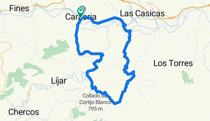
Cantoria-Barranco del Infierno-Albanchez-Cantoria.
Eine Fahrradroute, die in Cantoria, Andalusien, Spanien beginnt.
Übersicht
Über diese Route
Cantoria-Barranco del Infierno-Albanchez-Cantoria.
- -:--
- Dauer
- 32,8 km
- Distanz
- 763 m
- Aufstieg
- 762 m
- Abstieg
- ---
- Ø-Tempo
- ---
- Max. Höhe
Weiter mit Bikemap
Diese Radroute verwenden, bearbeiten oder herunterladen
Du möchtest Cantoria-Barranco del Infierno-Albanchez-Cantoria. fahren oder sie für deine eigene Reise anpassen? Folgendes kannst du mit dieser Bikemap-Route machen:
Gratis Funktionen
- Speichere diese Route als Favorit oder in einer Sammlung
- Kopiere & plane deine eigene Version dieser Route
- Synchronisiere deine Route mit Garmin oder Wahoo
Premium-Funktionen
Kostenlose Testversion für 3 Tage oder einmalige Zahlung. Mehr über Bikemap Premium.
- Navigiere diese Route auf iOS & Android
- Exportiere eine GPX / KML-Datei dieser Route
- Erstelle deinen individuellen Ausdruck (Jetzt kostenlos ausprobieren)
- Lade diese Route für die Offline-Navigation herunter
Entdecke weitere Premium-Funktionen.
Bikemap Premium aktivierenVon unserer Community
Cantoria: Andere beliebte Routen, die hier beginnen
 CANTORIA-ALBOX-TABERNO.
- Distanz
- 48,3 km
- Aufstieg
- 582 m
- Abstieg
- 582 m
- Standort
- Cantoria, Andalusien, Spanien
 RUTA CANTORIA AL SANTUARIO VIRGEN DE LA CABEZA.
- Distanz
- 66,3 km
- Aufstieg
- 1.012 m
- Abstieg
- 1.012 m
- Standort
- Cantoria, Andalusien, Spanien
 RUTA MORTIROLO 2011
- Distanz
- 32 km
- Aufstieg
- 366 m
- Abstieg
- 366 m
- Standort
- Cantoria, Andalusien, Spanien
 Cantoria-Barranco del Infierno-Albanchez-Cantoria.
- Distanz
- 32,8 km
- Aufstieg
- 763 m
- Abstieg
- 762 m
- Standort
- Cantoria, Andalusien, Spanien
 La Vuelta al Mundo -RCCR
- Distanz
- 54,7 km
- Aufstieg
- 769 m
- Abstieg
- 779 m
- Standort
- Cantoria, Andalusien, Spanien
 Por la via del tren y vuelta por el rio almanzora.
- Distanz
- 53,3 km
- Aufstieg
- 1.609 m
- Abstieg
- 1.609 m
- Standort
- Cantoria, Andalusien, Spanien
 Cantoria-La Silveria Cantoria -RCCR
- Distanz
- 63,7 km
- Aufstieg
- 924 m
- Abstieg
- 927 m
- Standort
- Cantoria, Andalusien, Spanien
 tramo libre cicloturistica de cantoria
- Distanz
- 15,6 km
- Aufstieg
- 499 m
- Abstieg
- 496 m
- Standort
- Cantoria, Andalusien, Spanien
In der App öffnen