Lighthouse Loop, Toronto
Eine Fahrradroute, die in Toronto, Ontario, Canada beginnt.
Übersicht
Über diese Route
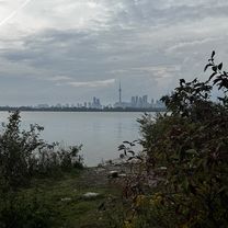
A fun and scenic loop at the Leslie Spit. The paved section is straight and fast. The unpaved section has many twists and turns along the shoreline. This loop begins and ends at the iconic lighthouse and is a great ride for doing laps solo or with friends.
- 20 min
- Dauer
- 6,5 km
- Distanz
- 34 m
- Aufstieg
- 4 m
- Abstieg
- 19,5 km/h
- Ø-Tempo
- 75 m
- Ø-Tempo
Fotos von der Route
Routenqualität
Wegtypen und Untergründe entlang der Route
Wegtypen
Ruhige Straße
3,5 km
(54 %)
Pfad
1,9 km
(30 %)
Untergründe
Befestigt
3,6 km
(55 %)
Unbefestigt
3 km
(45 %)
Asphalt
3,5 km
(54 %)
Schotter
2,1 km
(31 %)
Highlights der Route
POIs entlang der Route
Trinkwasser nach 3,6 km
Interessanter Ort nach 4,6 km
Floating bridge. Signs say to dismount but most cyclists just cross slowly.
Weiter mit Bikemap
Diese Radroute verwenden, bearbeiten oder herunterladen
Du möchtest Lighthouse Loop, Toronto fahren oder sie für deine eigene Reise anpassen? Folgendes kannst du mit dieser Bikemap-Route machen:
Gratis Funktionen
- Speichere diese Route als Favorit oder in einer Sammlung
- Kopiere & plane deine eigene Version dieser Route
- Synchronisiere deine Route mit Garmin oder Wahoo
Premium-Funktionen
Kostenlose Testversion für 3 Tage oder einmalige Zahlung. Mehr über Bikemap Premium.
- Navigiere diese Route auf iOS & Android
- Exportiere eine GPX / KML-Datei dieser Route
- Erstelle deinen individuellen Ausdruck (Jetzt kostenlos ausprobieren)
- Lade diese Route für die Offline-Navigation herunter
Entdecke weitere Premium-Funktionen.
Bikemap Premium aktivierenVon unserer Community
Toronto: Andere beliebte Routen, die hier beginnen
- Lawrence West to Union Station Via Sunnybrook, Taylor Creek, Boardwalk, Tommy Thompson Park
- Distanz
- 42,3 km
- Aufstieg
- 187 m
- Abstieg
- 282 m
- Standort
- Toronto, Ontario, Kanada
- - Short steep climbs & fast descents in the Beach
- Distanz
- 5,4 km
- Aufstieg
- 107 m
- Abstieg
- 110 m
- Standort
- Toronto, Ontario, Kanada
- Lawrence West to Union Station Via Centennial Park, Duck Pond, Humber River Trail,
- Distanz
- 45,5 km
- Aufstieg
- 285 m
- Abstieg
- 384 m
- Standort
- Toronto, Ontario, Kanada
- Cabana
- Distanz
- 13,1 km
- Aufstieg
- 91 m
- Abstieg
- 93 m
- Standort
- Toronto, Ontario, Kanada
- High Park
- Distanz
- 18,4 km
- Aufstieg
- 63 m
- Abstieg
- 63 m
- Standort
- Toronto, Ontario, Kanada
- 1 Waterfront Trail, Toronto to 2075 Queen St E, Toronto
- Distanz
- 4,3 km
- Aufstieg
- 3 m
- Abstieg
- 3 m
- Standort
- Toronto, Ontario, Kanada
- Cedarvale Park
- Distanz
- 5,9 km
- Aufstieg
- 39 m
- Abstieg
- 39 m
- Standort
- Toronto, Ontario, Kanada
- Eglinton West to Union Station Via Riverdale Farm and Tommy Thompson Park
- Distanz
- 33,2 km
- Aufstieg
- 98 m
- Abstieg
- 184 m
- Standort
- Toronto, Ontario, Kanada
In der App öffnen