

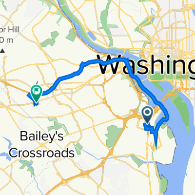
Capital Crescent - Georgetown Branch - Rock Crek Loop
Eine Fahrradroute, die in Washington, District of Columbia, Vereinigte Staaten beginnt.
Übersicht
Über diese Route
Dies ist eine perfekte 20-Meilen-Schleife mit sehr wenig Verkehr und nicht allzu großen Höhenunterschieden.
Am nördlichen Ende (Georgetown Branch) gibt es etwa ein bis zwei Meilen losen Schotter, aber der Rest ist asphaltierter Weg oder relativ ruhige Straßen.
Während der Stoßzeiten nicht zu empfehlen, da Beach Drive im Rock Creek Park ziemlich belebt sein kann. Es gibt Alternativrouten auf dem Trail, aber die Oberflächenqualität ist nicht so gut (Schlaglöcher usw.).
- -:--
- Dauer
- 32,5 km
- Distanz
- 172 m
- Aufstieg
- 174 m
- Abstieg
- ---
- Ø-Tempo
- ---
- Max. Höhe
Weiter mit Bikemap
Diese Radroute verwenden, bearbeiten oder herunterladen
Du möchtest Capital Crescent - Georgetown Branch - Rock Crek Loop fahren oder sie für deine eigene Reise anpassen? Folgendes kannst du mit dieser Bikemap-Route machen:
Gratis Funktionen
- Speichere diese Route als Favorit oder in einer Sammlung
- Kopiere & plane deine eigene Version dieser Route
- Synchronisiere deine Route mit Garmin oder Wahoo
Premium-Funktionen
Kostenlose Testversion für 3 Tage oder einmalige Zahlung. Mehr über Bikemap Premium.
- Navigiere diese Route auf iOS & Android
- Exportiere eine GPX / KML-Datei dieser Route
- Erstelle deinen individuellen Ausdruck (Jetzt kostenlos ausprobieren)
- Lade diese Route für die Offline-Navigation herunter
Entdecke weitere Premium-Funktionen.
Bikemap Premium aktivierenVon unserer Community
Washington: Andere beliebte Routen, die hier beginnen
 Washington Great Falls
- Distanz
- 42,8 km
- Aufstieg
- 295 m
- Abstieg
- 290 m
- Standort
- Washington, District of Columbia, Vereinigte Staaten
 2023 Coast-to-Coast (East-West) FINAL: 03Jun-28Jul2023
- Distanz
- 6.108 km
- Aufstieg
- 25.430 m
- Abstieg
- 25.472 m
- Standort
- Washington, District of Columbia, Vereinigte Staaten
 Rock Park 14 - 1
- Distanz
- 21,6 km
- Aufstieg
- 214 m
- Abstieg
- 218 m
- Standort
- Washington, District of Columbia, Vereinigte Staaten
 Haines’s point
- Distanz
- 17,4 km
- Aufstieg
- 70 m
- Abstieg
- 70 m
- Standort
- Washington, District of Columbia, Vereinigte Staaten
 1925 Constitution Ave NW, Washington to Constitution Ave NW, Washington
- Distanz
- 15,8 km
- Aufstieg
- 3 m
- Abstieg
- 9 m
- Standort
- Washington, District of Columbia, Vereinigte Staaten
 ANACOSTIA RIVER TRIAL RIDE
- Distanz
- 28,5 km
- Aufstieg
- 53 m
- Abstieg
- 53 m
- Standort
- Washington, District of Columbia, Vereinigte Staaten
 1211 S Eads St, Arlington to 601 N Manchester St, Arlington
- Distanz
- 18,7 km
- Aufstieg
- 4 m
- Abstieg
- 14 m
- Standort
- Washington, District of Columbia, Vereinigte Staaten
 Capital Crescent - Georgetown Branch - Rock Crek Loop
- Distanz
- 32,5 km
- Aufstieg
- 172 m
- Abstieg
- 174 m
- Standort
- Washington, District of Columbia, Vereinigte Staaten
In der App öffnen