

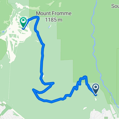
Central Lonsdale - Circle to Cypress Mountain Ski Station
Eine Fahrradroute, die in North Vancouver, British Columbia, Kanada beginnt.
Übersicht
Über diese Route
This was an excellent ride on roads with bike lanes, some unpaved trail, some residential streets, and Cypress Bowl Road, which is a major road, but it had very little traffic. It was an excellent climb to some altitude above 900 meters. Due to all the trees, there were only a few places where one could see the view from Cypress Bowl Road. It was pretty spectacular when one could see it.
- 5 h 46 min
- Dauer
- 56,1 km
- Distanz
- 1.594 m
- Aufstieg
- 1.576 m
- Abstieg
- 9,7 km/h
- Ø-Tempo
- 922 m
- Max. Höhe

Fotos von der Route


Routenqualität
Wegtypen und Untergründe entlang der Route
Wegtypen
Straße
40,9 km
(73 %)
Ruhige Straße
6,2 km
(11 %)
Untergründe
Befestigt
24,1 km
(43 %)
Unbefestigt
1,7 km
(3 %)
Asphalt
23,6 km
(42 %)
Unbefestigt (undefiniert)
1,1 km
(2 %)
Weiter mit Bikemap
Diese Radroute verwenden, bearbeiten oder herunterladen
Du möchtest Central Lonsdale - Circle to Cypress Mountain Ski Station fahren oder sie für deine eigene Reise anpassen? Folgendes kannst du mit dieser Bikemap-Route machen:
Gratis Funktionen
- Speichere diese Route als Favorit oder in einer Sammlung
- Kopiere & plane deine eigene Version dieser Route
- Synchronisiere deine Route mit Garmin oder Wahoo
Premium-Funktionen
Kostenlose Testversion für 3 Tage oder einmalige Zahlung. Mehr über Bikemap Premium.
- Navigiere diese Route auf iOS & Android
- Exportiere eine GPX / KML-Datei dieser Route
- Erstelle deinen individuellen Ausdruck (Jetzt kostenlos ausprobieren)
- Lade diese Route für die Offline-Navigation herunter
Entdecke weitere Premium-Funktionen.
Bikemap Premium aktivierenVon unserer Community
North Vancouver: Andere beliebte Routen, die hier beginnen
 Lillooet Road 2000, North Vancouver to Lillooet Road 2000, North Vancouver
- Distanz
- 31 km
- Aufstieg
- 311 m
- Abstieg
- 272 m
- Standort
- North Vancouver, British Columbia, Kanada
 Fromme parking lot to Grouse Mt, North Vancouver
- Distanz
- 9,1 km
- Aufstieg
- 688 m
- Abstieg
- 54 m
- Standort
- North Vancouver, British Columbia, Kanada
 Keith Rd E, North Vancouver to Gilmore Ave N, Burnaby
- Distanz
- 77,6 km
- Aufstieg
- 958 m
- Abstieg
- 874 m
- Standort
- North Vancouver, British Columbia, Kanada
 Hike Rice Lake Lynn Loop 9.5 km
- Distanz
- 9,6 km
- Aufstieg
- 294 m
- Abstieg
- 291 m
- Standort
- North Vancouver, British Columbia, Kanada
 161 E Sixth St, North Vancouver to 595 Keith Rd, West Vancouver
- Distanz
- 6,9 km
- Aufstieg
- 60 m
- Abstieg
- 92 m
- Standort
- North Vancouver, British Columbia, Kanada
 CVG - BMUT - TCT
- Distanz
- 32,4 km
- Aufstieg
- 223 m
- Abstieg
- 226 m
- Standort
- North Vancouver, British Columbia, Kanada
 N. Van Loop - 56k
- Distanz
- 56,1 km
- Aufstieg
- 1.111 m
- Abstieg
- 1.112 m
- Standort
- North Vancouver, British Columbia, Kanada
 80k SDF Loop
- Distanz
- 80,7 km
- Aufstieg
- 1.359 m
- Abstieg
- 1.357 m
- Standort
- North Vancouver, British Columbia, Kanada
In der App öffnen