

St MargaretsWay-Edinburgh to South Queensferry
Eine Fahrradroute, die in Edinburgh, Schottland, Vereinigtes Königreich beginnt.
Übersicht
Über diese Route
Quiet roads and bike tracks out of Edinburgh past famous historical landmarks to the famous Forth Road Bridge.
Starting at Eduardo Paolozzi's giant foot at the top of Leith Walk by St Mary's RC cathedral, then down a street of pubs and along Rocheid Path by the Waters of Leith this Way links up with the former railway line out of Edinburgh,now National Bike Route 1,over the historic Cramond Brig, through Dalmeny Estate to South Queensferry. Great views of the Forth Bridges and Fife coast.
Don't miss the famous secret garden along the Rocheid path.
This is the 1st section of St Margarets Way, the great 100km pilgrimage trail from Edinburgh to St Andrews, part of the revival of the 1000 year old pilgrimage, The Way of St Andrews.(http://www.thewayofstandrews.com)
- -:--
- Dauer
- 20,1 km
- Distanz
- 171 m
- Aufstieg
- 203 m
- Abstieg
- ---
- Ø-Tempo
- ---
- Max. Höhe

Highlights der Route
POIs entlang der Route
Interessanter Ort nach 10,3 km
Joins John Muir Way
Weiter mit Bikemap
Diese Radroute verwenden, bearbeiten oder herunterladen
Du möchtest St MargaretsWay-Edinburgh to South Queensferry fahren oder sie für deine eigene Reise anpassen? Folgendes kannst du mit dieser Bikemap-Route machen:
Gratis Funktionen
- Speichere diese Route als Favorit oder in einer Sammlung
- Kopiere & plane deine eigene Version dieser Route
- Synchronisiere deine Route mit Garmin oder Wahoo
Premium-Funktionen
Kostenlose Testversion für 3 Tage oder einmalige Zahlung. Mehr über Bikemap Premium.
- Navigiere diese Route auf iOS & Android
- Exportiere eine GPX / KML-Datei dieser Route
- Erstelle deinen individuellen Ausdruck (Jetzt kostenlos ausprobieren)
- Lade diese Route für die Offline-Navigation herunter
Entdecke weitere Premium-Funktionen.
Bikemap Premium aktivierenVon unserer Community
Edinburgh: Andere beliebte Routen, die hier beginnen
 Route to Tynecastle High School
- Distanz
- 18 km
- Aufstieg
- 138 m
- Abstieg
- 138 m
- Standort
- Edinburgh, Schottland, Vereinigtes Königreich
 Edinburgh-Rosewell Route
- Distanz
- 33,4 km
- Aufstieg
- 331 m
- Abstieg
- 331 m
- Standort
- Edinburgh, Schottland, Vereinigtes Königreich
 Cycling to Balerno
- Distanz
- 12 km
- Aufstieg
- 125 m
- Abstieg
- 32 m
- Standort
- Edinburgh, Schottland, Vereinigtes Königreich
 training Edinburgh
- Distanz
- 22,7 km
- Aufstieg
- 227 m
- Abstieg
- 227 m
- Standort
- Edinburgh, Schottland, Vereinigtes Königreich
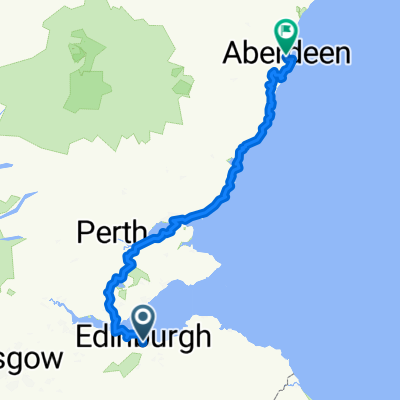 Sco03 Edinburgh-Aberdeen
- Distanz
- 254,7 km
- Aufstieg
- 1.169 m
- Abstieg
- 1.226 m
- Standort
- Edinburgh, Schottland, Vereinigtes Königreich
 From Edinburgh to Kelpies
- Distanz
- 46,9 km
- Aufstieg
- 341 m
- Abstieg
- 422 m
- Standort
- Edinburgh, Schottland, Vereinigtes Königreich
 Meadows - Roslin - Gladhouse Reservoir - Crichton - Cousland - NCN1
- Distanz
- 73,7 km
- Aufstieg
- 457 m
- Abstieg
- 457 m
- Standort
- Edinburgh, Schottland, Vereinigtes Königreich
 100k april 2025
- Distanz
- 92,8 km
- Aufstieg
- 780 m
- Abstieg
- 763 m
- Standort
- Edinburgh, Schottland, Vereinigtes Königreich
In der App öffnen