

Mission - Circle to Durieu 2
Eine Fahrradroute, die in Abbotsford, British Columbia, Kanada beginnt.
Übersicht
Über diese Route
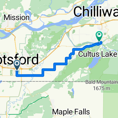
Das war bisher unsere beste Fahrt seit wir vor etwa einer Woche nach Kanada geradelt sind. Wir waren auf einigen ausgezeichneten Wald- und Landstraßen mit minimalem Verkehr und schöner Landschaft unterwegs. Nur ein oder zwei Meilen der Fahrt waren auf dem Highway 7, der in diesem Abschnitt einen guten Seitenstreifen hat. Die Nutzung der Dewdney Trunk Road vom Highway 7 (mit einem kleinen Umweg über eine fahrradfreundlichere Straße) war viel besser als unsere bisher „beste Fahrt durch Durieu“, bei der wir den Highway 7 bis zur Nelson Street benutzt haben. Insgesamt eine ausgezeichnete Fahrt.
Hinweis für eine längere Fahrt: Beim Blick auf die Karte sehe ich, dass wir weiter nördlich auf der Slave Lake Road hätten fahren und dann über die Hartley Road auf die Sylvester Road hätten abbiegen können. Das hätte zusätzliche Kilometer gebracht und vermutlich mehr schöne Landschaft und Fahrmöglichkeit.
- 2 h 44 min
- Dauer
- 40,4 km
- Distanz
- 664 m
- Aufstieg
- 667 m
- Abstieg
- 14,8 km/h
- Ø-Tempo
- 179 m
- Max. Höhe

Fotos von der Route


Routenqualität
Wegtypen und Untergründe entlang der Route
Wegtypen
Straße
17,4 km
(43 %)
Ruhige Straße
8,5 km
(21 %)
Untergründe
Befestigt
12,1 km
(30 %)
Asphalt
12,1 km
(30 %)
Undefiniert
28,3 km
(70 %)
Weiter mit Bikemap
Diese Radroute verwenden, bearbeiten oder herunterladen
Du möchtest Mission - Circle to Durieu 2 fahren oder sie für deine eigene Reise anpassen? Folgendes kannst du mit dieser Bikemap-Route machen:
Gratis Funktionen
- Speichere diese Route als Favorit oder in einer Sammlung
- Kopiere & plane deine eigene Version dieser Route
- Synchronisiere deine Route mit Garmin oder Wahoo
Premium-Funktionen
Kostenlose Testversion für 3 Tage oder einmalige Zahlung. Mehr über Bikemap Premium.
- Navigiere diese Route auf iOS & Android
- Exportiere eine GPX / KML-Datei dieser Route
- Erstelle deinen individuellen Ausdruck (Jetzt kostenlos ausprobieren)
- Lade diese Route für die Offline-Navigation herunter
Entdecke weitere Premium-Funktionen.
Bikemap Premium aktivierenVon unserer Community
Abbotsford: Andere beliebte Routen, die hier beginnen
 Poplar, Abbotsford to Caen Ave, Chilliwack
- Distanz
- 33,5 km
- Aufstieg
- 88 m
- Abstieg
- 123 m
- Standort
- Abbotsford, British Columbia, Kanada
 Bateman Road to Picton Street
- Distanz
- 31,8 km
- Aufstieg
- 94 m
- Abstieg
- 47 m
- Standort
- Abbotsford, British Columbia, Kanada
 VC6-AbotBBar
- Distanz
- 153,3 km
- Aufstieg
- 739 m
- Abstieg
- 591 m
- Standort
- Abbotsford, British Columbia, Kanada
 Aug 10 Silverdale
- Distanz
- 35,3 km
- Aufstieg
- 387 m
- Abstieg
- 341 m
- Standort
- Abbotsford, British Columbia, Kanada
 Canada
- Distanz
- 77,5 km
- Aufstieg
- 304 m
- Abstieg
- 330 m
- Standort
- Abbotsford, British Columbia, Kanada
 Long Prairie
- Distanz
- 33,7 km
- Aufstieg
- 35 m
- Abstieg
- 86 m
- Standort
- Abbotsford, British Columbia, Kanada
 Joanne's loop
- Distanz
- 37,8 km
- Aufstieg
- 143 m
- Abstieg
- 146 m
- Standort
- Abbotsford, British Columbia, Kanada
 Poplar, Abbotsford to Caen Ave, Chilliwack
- Distanz
- 35,9 km
- Aufstieg
- 287 m
- Abstieg
- 321 m
- Standort
- Abbotsford, British Columbia, Kanada
In der App öffnen