

St Margaret's Way-Burntisland to Leven
Eine Fahrradroute, die in Burntisland, Schottland, Vereinigtes Königreich beginnt.
Übersicht
Über diese Route
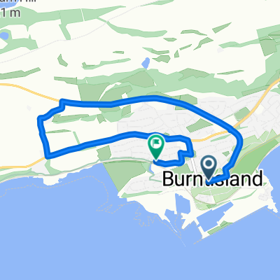
Going out Burntisland along a short strip of main road ,with a pedestrian walkway alongside, the Way returns to a quiet section of the Fife Coastal Path, past Kinghorn , where a Scottish king fell to his death, and onto Kirkcaldy, once the linoleum capital of Scotland . The path can become muddy as it skirts the coast. Across the water, the extinct volcanoes of the Bass Rock and North Berwick Law are visible.
Leaving Kirkcaldy and passing the grandly built old linoleum factory the Way descends abruptly to the beach, with the 15th century Ravenscraig Castle towering above. Then the Way follows the signposted Fife Coastal Path through former fishing and coalmining villages and past ancient buildings and memorials to Lundin Links and Leven.
This is the 3rd section of St Margaret’s Way, the great 100km pilgrimage trail from Edinburgh to St Andrews, part of the revival of the 1000 year old pilgrimage, The Way of St Andrews. (http://www.thewayofstandrews.com)
- -:--
- Dauer
- 23,8 km
- Distanz
- 126 m
- Aufstieg
- 119 m
- Abstieg
- ---
- Ø-Tempo
- ---
- Max. Höhe

Highlights der Route
POIs entlang der Route

Interessanter Ort nach 7,3 km
This limestone bed was formed at the bottom of a warm shallow sea when this part of Scotland was near the Equator. Here the bed has been compressed horizontally so the hard limestone has cracked and one slab has slid over the other. This feature is called a thrust fault. More signs of volcanic activity lie just south of the breakwater. Here there is a reef formed by molten rock (basalt), which has squeezed between horizontal layers of sandstone. This feature is called a sill. Thanks to geoHeritage Fife for advice and image.
Weiter mit Bikemap
Diese Radroute verwenden, bearbeiten oder herunterladen
Du möchtest St Margaret's Way-Burntisland to Leven fahren oder sie für deine eigene Reise anpassen? Folgendes kannst du mit dieser Bikemap-Route machen:
Gratis Funktionen
- Speichere diese Route als Favorit oder in einer Sammlung
- Kopiere & plane deine eigene Version dieser Route
- Synchronisiere deine Route mit Garmin oder Wahoo
Premium-Funktionen
Kostenlose Testversion für 3 Tage oder einmalige Zahlung. Mehr über Bikemap Premium.
- Navigiere diese Route auf iOS & Android
- Exportiere eine GPX / KML-Datei dieser Route
- Erstelle deinen individuellen Ausdruck (Jetzt kostenlos ausprobieren)
- Lade diese Route für die Offline-Navigation herunter
Entdecke weitere Premium-Funktionen.
Bikemap Premium aktivierenVon unserer Community
Burntisland: Andere beliebte Routen, die hier beginnen
 Tour of the Kingdom Ride 130km route
- Distanz
- 129 km
- Aufstieg
- 792 m
- Abstieg
- 774 m
- Standort
- Burntisland, Schottland, Vereinigtes Königreich
 St Margaret's Way-Burntisland to Leven
- Distanz
- 23,8 km
- Aufstieg
- 126 m
- Abstieg
- 119 m
- Standort
- Burntisland, Schottland, Vereinigtes Königreich
 School 2
- Distanz
- 5,3 km
- Aufstieg
- 82 m
- Abstieg
- 89 m
- Standort
- Burntisland, Schottland, Vereinigtes Königreich
 InvkLeuc
- Distanz
- 60,7 km
- Aufstieg
- 464 m
- Abstieg
- 465 m
- Standort
- Burntisland, Schottland, Vereinigtes Königreich
 BIsCupar
- Distanz
- 47,3 km
- Aufstieg
- 369 m
- Abstieg
- 354 m
- Standort
- Burntisland, Schottland, Vereinigtes Königreich
 BislLeuc
- Distanz
- 59,8 km
- Aufstieg
- 429 m
- Abstieg
- 418 m
- Standort
- Burntisland, Schottland, Vereinigtes Königreich
 Lengthy bike tour from カーコーディー to セントアンドリューズ
- Distanz
- 52,2 km
- Aufstieg
- 390 m
- Abstieg
- 492 m
- Standort
- Burntisland, Schottland, Vereinigtes Königreich
In der App öffnen