
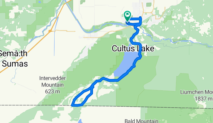
Chilliwack - Circle to Canadian-US border via Lake Cultus, Henderson Rd, and Maple Falls Rd.
Eine Fahrradroute, die in Chilliwack, British Columbia, Kanada beginnt.
Übersicht
Über diese Route
Insgesamt war das eine ziemlich schöne Fahrt. (Das war das zweite Mal, dass wir den größten Teil dieser Fahrt gemacht haben.) Im ersten Teil der Fahrt gab es zu viel Verkehr, aber nachdem wir südlich des Cultus-Sees vorbeigefahren waren, war der Verkehr fast vollständig verschwunden.
Wir fuhren das Ende Mai. Angesichts aller Camping- und Touristenattraktionen am See können wir uns vorstellen, dass der Verkehr bis zum Ende des Sees im Sommer während der Touristensaison schrecklich sein wird.
Für die Abschnitte der Fahrt mit Verkehr gab es im Allgemeinen einen guten Seitenstreifen zum Fahren. Nach dem See benötigten wir keinen Fahrbahnrand. Dieser Teil war fast wie im Nirwana.
- 3 h 21 min
- Dauer
- 44 km
- Distanz
- 532 m
- Aufstieg
- 545 m
- Abstieg
- 13,1 km/h
- Ø-Tempo
- 214 m
- Max. Höhe

Fotos von der Route


Routenqualität
Wegtypen und Untergründe entlang der Route
Wegtypen
Straße
5,7 km
(13 %)
Radweg
2,6 km
(6 %)
Untergründe
Befestigt
28,1 km
(64 %)
Unbefestigt
1,8 km
(4 %)
Asphalt
27,3 km
(62 %)
Schotter
1,8 km
(4 %)
Weiter mit Bikemap
Diese Radroute verwenden, bearbeiten oder herunterladen
Du möchtest Chilliwack - Circle to Canadian-US border via Lake Cultus, Henderson Rd, and Maple Falls Rd. fahren oder sie für deine eigene Reise anpassen? Folgendes kannst du mit dieser Bikemap-Route machen:
Gratis Funktionen
- Speichere diese Route als Favorit oder in einer Sammlung
- Kopiere & plane deine eigene Version dieser Route
- Synchronisiere deine Route mit Garmin oder Wahoo
Premium-Funktionen
Kostenlose Testversion für 3 Tage oder einmalige Zahlung. Mehr über Bikemap Premium.
- Navigiere diese Route auf iOS & Android
- Exportiere eine GPX / KML-Datei dieser Route
- Erstelle deinen individuellen Ausdruck (Jetzt kostenlos ausprobieren)
- Lade diese Route für die Offline-Navigation herunter
Entdecke weitere Premium-Funktionen.
Bikemap Premium aktivierenVon unserer Community
Chilliwack: Andere beliebte Routen, die hier beginnen
 bikey mcfunstein
- Distanz
- 72,1 km
- Aufstieg
- 553 m
- Abstieg
- 449 m
- Standort
- Chilliwack, British Columbia, Kanada
 Chilliwack to Hope
- Distanz
- 65,3 km
- Aufstieg
- 816 m
- Abstieg
- 802 m
- Standort
- Chilliwack, British Columbia, Kanada
 Chilliwack - Circle to Canadian-US border via Lake Cultus and Iverson Rd
- Distanz
- 44,8 km
- Aufstieg
- 777 m
- Abstieg
- 774 m
- Standort
- Chilliwack, British Columbia, Kanada
 Slow ride in Chilliwack
- Distanz
- 21,2 km
- Aufstieg
- 34 m
- Abstieg
- 70 m
- Standort
- Chilliwack, British Columbia, Kanada
 duck route
- Distanz
- 72,1 km
- Aufstieg
- 335 m
- Abstieg
- 344 m
- Standort
- Chilliwack, British Columbia, Kanada
 Relaxed route in Chilliwack
- Distanz
- 6,4 km
- Aufstieg
- 9 m
- Abstieg
- 12 m
- Standort
- Chilliwack, British Columbia, Kanada
 最後一天
最後一天- Distanz
- 120,3 km
- Aufstieg
- 562 m
- Abstieg
- 567 m
- Standort
- Chilliwack, British Columbia, Kanada
 Chilliwack - Circle toward Chilliwack Lake
- Distanz
- 45 km
- Aufstieg
- 457 m
- Abstieg
- 457 m
- Standort
- Chilliwack, British Columbia, Kanada
In der App öffnen