

Lone Wolf heads across the northern USA
Eine Fahrradroute, die in Mill Plain, Washington, Vereinigte Staaten beginnt.
Übersicht
Über diese Route
Die Route, die ich fahren werde, ist eine Mischung aus verschiedenen Teilen der Adventure Cycling-Routen. Ich nehme an, ich könnte einen neuen Namen kreieren, aber das wäre zu schwer. Ich werde in Camas, WA, starten; zum Pazifischen Ozean fahren, um das Rad einzutauchen, dann wieder nach Osten in Richtung Atlantikküste fahren. Ich werde alleine weiterfahren, die ACA-Route von Lewis & Clark nach Missoula, MT, folgen; dann die Great Parks North-Route zum Glacier NP, nach Osten entlang der Northern Tier-Route bis Minnesota, dann entlang der Great Lakes-Route fahren, bis ich den Lake Erie Connector erreiche, und dann zurück auf die Northern Tier-Route, bis ich die Atlantikküste erreiche... und dann nach Süden entlang der Atlantik-Route fahren, bis ich das Haus meines Bruders in Norwich, CT, erreiche.
- -:--
- Dauer
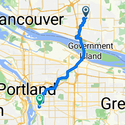
- 23,3 km
- Distanz
- 63 m
- Aufstieg
- 149 m
- Abstieg
- ---
- Ø-Tempo
- ---
- Max. Höhe

Weiter mit Bikemap
Diese Radroute verwenden, bearbeiten oder herunterladen
Du möchtest Lone Wolf heads across the northern USA fahren oder sie für deine eigene Reise anpassen? Folgendes kannst du mit dieser Bikemap-Route machen:
Gratis Funktionen
- Speichere diese Route als Favorit oder in einer Sammlung
- Kopiere & plane deine eigene Version dieser Route
- Synchronisiere deine Route mit Garmin oder Wahoo
Premium-Funktionen
Kostenlose Testversion für 3 Tage oder einmalige Zahlung. Mehr über Bikemap Premium.
- Navigiere diese Route auf iOS & Android
- Exportiere eine GPX / KML-Datei dieser Route
- Erstelle deinen individuellen Ausdruck (Jetzt kostenlos ausprobieren)
- Lade diese Route für die Offline-Navigation herunter
Entdecke weitere Premium-Funktionen.
Bikemap Premium aktivierenVon unserer Community
Mill Plain: Andere beliebte Routen, die hier beginnen
 Route to Northeast Alderwood Road 10101, Portland
- Distanz
- 20,5 km
- Aufstieg
- 64 m
- Abstieg
- 43 m
- Standort
- Mill Plain, Washington, Vereinigte Staaten
 AROUND LACAMAS LAKE
- Distanz
- 28,1 km
- Aufstieg
- 208 m
- Abstieg
- 205 m
- Standort
- Mill Plain, Washington, Vereinigte Staaten
 Northeast Alderwood Road 10101, Portland to Northeast Alberta Street 1500, Portland
- Distanz
- 10,1 km
- Aufstieg
- 89 m
- Abstieg
- 4 m
- Standort
- Mill Plain, Washington, Vereinigte Staaten
 Portland, OR to Northern Oregon Coast Circuit
- Distanz
- 548,1 km
- Aufstieg
- 1.099 m
- Abstieg
- 1.090 m
- Standort
- Mill Plain, Washington, Vereinigte Staaten
 Lone Wolf heads across the northern USA
- Distanz
- 23,3 km
- Aufstieg
- 63 m
- Abstieg
- 149 m
- Standort
- Mill Plain, Washington, Vereinigte Staaten
 Vancouver Clear Meadows Ride
- Distanz
- 65,3 km
- Aufstieg
- 165 m
- Abstieg
- 161 m
- Standort
- Mill Plain, Washington, Vereinigte Staaten
 Bears Paradise
- Distanz
- 106,9 km
- Aufstieg
- 1.309 m
- Abstieg
- 1.272 m
- Standort
- Mill Plain, Washington, Vereinigte Staaten
 best ride ever
- Distanz
- 24,8 km
- Aufstieg
- 147 m
- Abstieg
- 220 m
- Standort
- Mill Plain, Washington, Vereinigte Staaten
In der App öffnen