

Jens Erik trip 2024
2 Oct Route Reggio Emilia to river Po
Eine Fahrradroute, die in Reggio nell'Emilia, Emilia-Romagna, Italien beginnt.
Übersicht
Über diese Route
A route that stitches together stretches of cycle paths with stretches of minor roads crossing the plain from south to north in the "small capitals" of the history of the possessions of the Bentivoglio and Gonzaga families in the province of Reggio Emilia until reaching the Po river. We cross Bagnolo in Piano, Novellara and the suggestive territory of the Valleys, Guastalla with its Romanesque parish churches, the Palazzo Ducale up to the Lido Po at the old mooring of the pontoon bridge. From the Lido a floating bridge allows us to cross the Crostolo stream at the mouth of the Po and continue towards Gualtieri along the towpath which is now a cycle path. After a stop in the beautiful Piazza Bentivoglio (a square of 100 meters on each side) we return to Reggio Emilia, the embankment of the Crostolo stream, then the minor roads up to the town of Sesso and then the urban cycle paths to enter the city Percorso che ricuce tratti di piste ciclabili con tratti su viabilità minore attraversando la pianura da sud a nord nelle “piccole capitali” della storia dei possedimenti dei Bentivoglio e dei Gonzaga della provincia di Reggio Emilia fino da arrivare al fiume Po. Attraversiamo Bagnolo in Piano, Novellara e il territorio suggestivo delle Valli, Guastalla con le sue pievi romaniche il Palazzo Ducale fino al Lido Po in corrispondenza del vecchio attracco del ponte di barche. Dal Lido un ponte flottante ci consente di passare il torrente Crostolo alla foce del Po e di proseguire per Gualtieri lungo la strada alzaia oggi pista ciclabile. Dopo una sosta nella bella Piazza Bentivoglio (un quadrato di 100 metri di lato) ritorniamo a Reggio Emilia l’argine del torrente Crostolo quindi la viabilità minore fino all’abitato di Sesso e quindi le ciclabili urbane per entrare in città
- 4 h 18 min
- Dauer
- 71,4 km
- Distanz
- 82 m
- Aufstieg
- 79 m
- Abstieg
- 16,6 km/h
- Ø-Tempo
- 50 m
- Max. Höhe

Teil von
8 Etappen
Routenqualität
Wegtypen und Untergründe entlang der Route
Wegtypen
Ruhige Straße
33,6 km
(47 %)
Radweg
17,1 km
(24 %)
Untergründe
Befestigt
40,7 km
(57 %)
Unbefestigt
3,6 km
(5 %)
Asphalt
35 km
(49 %)
Befestigt (undefiniert)
3,6 km
(5 %)
Highlights der Route
POIs entlang der Route

Interessanter Ort nach 11,2 km
Pieve Rossa romanesque church

Interessanter Ort nach 20,3 km
Main church

Interessanter Ort nach 29,7 km
Strada bianca
Interessanter Ort nach 32 km
Attention dangerous crossing

Interessanter Ort nach 34,8 km
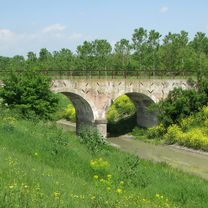
Pieve di Guastalla church

Interessanter Ort nach 39 km
Lido Po lunch time

Interessanter Ort nach 39,2 km
Floating bridge

Interessanter Ort nach 39,4 km
Towpath cycling route

Interessanter Ort nach 42,4 km
Bentivoglio square

Interessanter Ort nach 44,4 km
White road to the bank of Crostolo stream

Interessanter Ort nach 45,9 km
Cycle-foot bridge on Crostolo Stream

Interessanter Ort nach 53,3 km
Argine Francone road
Weiter mit Bikemap
Diese Radroute verwenden, bearbeiten oder herunterladen
Du möchtest 2 Oct Route Reggio Emilia to river Po fahren oder sie für deine eigene Reise anpassen? Folgendes kannst du mit dieser Bikemap-Route machen:
Gratis Funktionen
- Speichere diese Route als Favorit oder in einer Sammlung
- Kopiere & plane deine eigene Version dieser Route
- Synchronisiere deine Route mit Garmin oder Wahoo
Premium-Funktionen
Kostenlose Testversion für 3 Tage oder einmalige Zahlung. Mehr über Bikemap Premium.
- Navigiere diese Route auf iOS & Android
- Exportiere eine GPX / KML-Datei dieser Route
- Erstelle deinen individuellen Ausdruck (Jetzt kostenlos ausprobieren)
- Lade diese Route für die Offline-Navigation herunter
Entdecke weitere Premium-Funktionen.
Bikemap Premium aktivierenVon unserer Community
Reggio nell'Emilia: Andere beliebte Routen, die hier beginnen
 Canossa da Reggio Canalina, via Montecavolo
- Distanz
- 64,9 km
- Aufstieg
- 720 m
- Abstieg
- 720 m
- Standort
- Reggio nell'Emilia, Emilia-Romagna, Italien
 Reggio Emilia_Quattro Castella Atualizado_28/05/2014
- Distanz
- 16,2 km
- Aufstieg
- 117 m
- Abstieg
- 10 m
- Standort
- Reggio nell'Emilia, Emilia-Romagna, Italien
 Reggio Emilia-ciclabile Crostolo-Quattro Castella
- Distanz
- 20,3 km
- Aufstieg
- 132 m
- Abstieg
- 21 m
- Standort
- Reggio nell'Emilia, Emilia-Romagna, Italien
 c) Percorso Gonzaghesco: Reggio Emilia - Novellara - Guastalla
- Distanz
- 36 km
- Aufstieg
- 34 m
- Abstieg
- 63 m
- Standort
- Reggio nell'Emilia, Emilia-Romagna, Italien
 Giri in bici per famiglie Reggio-Bagnolo-Correggio A-R
- Distanz
- 39,9 km
- Aufstieg
- 56 m
- Abstieg
- 54 m
- Standort
- Reggio nell'Emilia, Emilia-Romagna, Italien
 Reggio Emilia to Mamiano (Pr) Fondazione M.R.
- Distanz
- 31,2 km
- Aufstieg
- 172 m
- Abstieg
- 68 m
- Standort
- Reggio nell'Emilia, Emilia-Romagna, Italien
 Poco asfalto Reggio Novellara Guastalla
- Distanz
- 70,9 km
- Aufstieg
- 76 m
- Abstieg
- 75 m
- Standort
- Reggio nell'Emilia, Emilia-Romagna, Italien
 Cammino San Pellegrino
- Distanz
- 95,7 km
- Aufstieg
- 2.895 m
- Abstieg
- 1.442 m
- Standort
- Reggio nell'Emilia, Emilia-Romagna, Italien
In der App öffnen