

Bangar, bike and Bukit Patoi
Eine Fahrradroute, die in Bangar, Temburong, Brunei Darussalam beginnt.
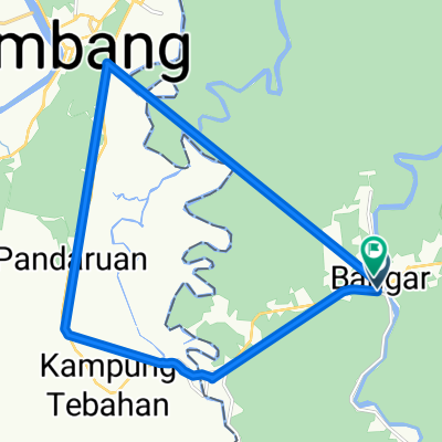
Übersicht
Über diese Route
Dies ist eine kombinierte Rad- und Wanderung von Bangar nach Bukit Patoi. Die Straße ist eine ausgezeichnete Autobahn, größtenteils mit einem breiten Schultern, und der 300 m Anstieg zum Bukit Patoi folgt einem sehr gut genutzten Pfad. Am Fuß des Anstiegs befinden sich Gebäude, einschließlich Toiletten und Wasser. Stellen Sie sicher, dass Sie oft trinken.
Am besten wird die Tour früh am Morgen gemacht, um die Hitze zu vermeiden. Trotzdem werden Sie viel schwitzen. Die Fahrt und die Wanderung dauern jeweils etwas mehr als eine halbe Stunde, also geben Sie sich drei Stunden Zeit, um die Umgebung zu erkunden und es abzuschließen.
Ein Tagesrucksack mit einem Paar griffiger Stiefel und ein paar Wasserflaschen ist eine gute Idee. Die größte Gefahr sind die glitschigen (lackierten!) Betonstufen am Anfang des Anstiegs. Halten Sie beim Abstieg die Hand am Geländer, da Regen und Moos es schlimmer machen.
- -:--
- Dauer
- 16,1 km
- Distanz
- 388 m
- Aufstieg
- 109 m
- Abstieg
- ---
- Ø-Tempo
- ---
- Max. Höhe

Weiter mit Bikemap
Diese Radroute verwenden, bearbeiten oder herunterladen
Du möchtest Bangar, bike and Bukit Patoi fahren oder sie für deine eigene Reise anpassen? Folgendes kannst du mit dieser Bikemap-Route machen:
Gratis Funktionen
- Speichere diese Route als Favorit oder in einer Sammlung
- Kopiere & plane deine eigene Version dieser Route
- Synchronisiere deine Route mit Garmin oder Wahoo
Premium-Funktionen
Kostenlose Testversion für 3 Tage oder einmalige Zahlung. Mehr über Bikemap Premium.
- Navigiere diese Route auf iOS & Android
- Exportiere eine GPX / KML-Datei dieser Route
- Erstelle deinen individuellen Ausdruck (Jetzt kostenlos ausprobieren)
- Lade diese Route für die Offline-Navigation herunter
Entdecke weitere Premium-Funktionen.
Bikemap Premium aktivierenVon unserer Community
Bangar: Andere beliebte Routen, die hier beginnen
 Temburong border to border
- Distanz
- 26,9 km
- Aufstieg
- 292 m
- Abstieg
- 271 m
- Standort
- Bangar, Temburong, Brunei Darussalam
 Bukit Patoi extension walk
- Distanz
- 1,1 km
- Aufstieg
- 88 m
- Abstieg
- 28 m
- Standort
- Bangar, Temburong, Brunei Darussalam
 Bangar Puni Bukok Rataie Loop
- Distanz
- 27,4 km
- Aufstieg
- 303 m
- Abstieg
- 301 m
- Standort
- Bangar, Temburong, Brunei Darussalam
 Temburong Practice Run
- Distanz
- 13 km
- Aufstieg
- 102 m
- Abstieg
- 86 m
- Standort
- Bangar, Temburong, Brunei Darussalam
 Blistering ride
- Distanz
- 22,3 km
- Aufstieg
- 49 m
- Abstieg
- 39 m
- Standort
- Bangar, Temburong, Brunei Darussalam
 Afternoon Ride
- Distanz
- 15 km
- Aufstieg
- 157 m
- Abstieg
- 133 m
- Standort
- Bangar, Temburong, Brunei Darussalam
 Brunei, Bangar to Brunei, Bangar
- Distanz
- 2 km
- Aufstieg
- 12 m
- Abstieg
- 12 m
- Standort
- Bangar, Temburong, Brunei Darussalam
 Temada-Sibut track
- Distanz
- 6,8 km
- Aufstieg
- 108 m
- Abstieg
- 117 m
- Standort
- Bangar, Temburong, Brunei Darussalam
In der App öffnen