

Port Townsend to Olympia
Eine Fahrradroute, die in Port Townsend, Washington, United States of America beginnt.
Übersicht
Über diese Route
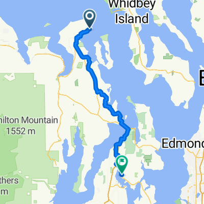
Start anywhere you want in Port Townsend, as route 20 is almost the only way to leave town. At the first light continue straight on to Rt. 19. This will bring you to Chimacum. At the blinking red light 4-way stop go right onto Center Rd., which will take you all the way to Quilcene. In Quilcene you will meet 101, which will take you all the way to Olympia. The reason for taking Center Rd is that Rt 20 south of Port Townsend is hilly, curvy, without any shoulder, and dangerous. Center Rd. has a very wide shoulder, as well as many farms and Mt Views.
There is a big hill just before Quilcene, and then a pass between Quilcene and Bremerton. This is the most difficult stretch of the ride. Rt 101 is moderately hilly, and often only a small shoulder. I recommend finding a day outside the main tourist season, when 101 is not heavily travelled. The views of the sound are stunning. Enjoy!
- -:--
- Dauer
- 156,7 km
- Distanz
- 753 m
- Aufstieg
- 807 m
- Abstieg
- ---
- Ø-Tempo
- ---
- Ø-Tempo

Weiter mit Bikemap
Diese Radroute verwenden, bearbeiten oder herunterladen
Du möchtest Port Townsend to Olympia fahren oder sie für deine eigene Reise anpassen? Folgendes kannst du mit dieser Bikemap-Route machen:
Gratis Funktionen
- Speichere diese Route als Favorit oder in einer Sammlung
- Kopiere & plane deine eigene Version dieser Route
- Synchronisiere deine Route mit Garmin oder Wahoo
Premium-Funktionen
Kostenlose Testversion für 3 Tage oder einmalige Zahlung. Mehr über Bikemap Premium.
- Navigiere diese Route auf iOS & Android
- Exportiere eine GPX / KML-Datei dieser Route
- Erstelle deinen individuellen Ausdruck (Jetzt kostenlos ausprobieren)
- Lade diese Route für die Offline-Navigation herunter
Entdecke weitere Premium-Funktionen.
Bikemap Premium aktivierenVon unserer Community
Port Townsend: Andere beliebte Routen, die hier beginnen
 1059–1199 Hastings Ave, Port Townsend to 1329 22nd St, Port Townsend
- Distanz
- 11,5 km
- Aufstieg
- 163 m
- Abstieg
- 167 m
- Standort
- Port Townsend, Washington, USA
 Larry Scott
- Distanz
- 30,7 km
- Aufstieg
- 345 m
- Abstieg
- 347 m
- Standort
- Port Townsend, Washington, USA
 Olympic Discovery Trail
- Distanz
- 84 km
- Aufstieg
- 517 m
- Abstieg
- 494 m
- Standort
- Port Townsend, Washington, USA
 pt to lc
- Distanz
- 115,2 km
- Aufstieg
- 831 m
- Abstieg
- 643 m
- Standort
- Port Townsend, Washington, USA
 628 Water St, Port Townsend nach 9072 Beaver Valley Rd, Chimacum
- Distanz
- 23,1 km
- Aufstieg
- 384 m
- Abstieg
- 355 m
- Standort
- Port Townsend, Washington, USA
 Hudson St, Port Townsend to Milo Curry Rd, Port Townsend
- Distanz
- 14,9 km
- Aufstieg
- 139 m
- Abstieg
- 109 m
- Standort
- Port Townsend, Washington, USA
 Day 1
Day 1- Distanz
- 122,1 km
- Aufstieg
- 669 m
- Abstieg
- 606 m
- Standort
- Port Townsend, Washington, USA
 1300–1398 Clay St, Port Townsend to 18680 State Highway 305 NE, Poulsbo
- Distanz
- 63,9 km
- Aufstieg
- 997 m
- Abstieg
- 1.005 m
- Standort
- Port Townsend, Washington, USA
In der App öffnen