

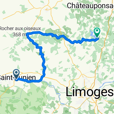
2009 Euro Tour -- Ride Day 2 -- 21 June 2009 -- 87200 Saint-Julien to 87400 Saint-Léonard-de-Noblat
Eine Fahrradroute, die in Saint-Junien, Nouvelle-Aquitaine, Frankreich beginnt.
Übersicht
Über diese Route
Fahrt Tag 2
—21. Juni 2009—87200 Saint-Julien nach 87400 Saint-Léonard-de-Noblat
Ein weiterer schöner Tag mit tollem Wetter und herausragenden Straßen. Fast alle Straßen nach dem Verlassen der A20 waren perfekte, wenig befahrene Landstraßen. Heute war das bergauf Fahren oft steiler, und nichts (außer der kurzen Zeit auf der A20) war flach.
Unsere Route führte uns durch Oradour-sur-Glane, das aus historischer Sicht während des Zweiten Weltkriegs von besonderer Bedeutung ist. Die gesamte Fahrt fand innerhalb von Haute-Vienne statt.
Hintergrund:
Meine Frau und ich machen seit 1993 selbstunterstützte Touren in Westeuropa (vorwiegend in Frankreich). Diese Reihe von Fahrten deckt unsere 4,5-monatige Route im Jahr 2009 durch Teile von Frankreich, Deutschland, Österreich, die Schweiz und dann zurück nach Frankreich ab. Unser Anfangs- und Endpunkt ist in der Nähe von Chadurie (nördlich von Angoulême), wo unsere Freunde eine Farm mit Gîtes und Chambres d'Hôtes haben.
Wir fuhren mit unseren Dawes-Tourenfahrrädern, die wir 1993 gekauft haben, stark beladen mit 700Cx32 Reifen. Alle unsere Fahrten fanden auf asphaltierten Straßen statt, meist mit sehr wenig Verkehr. Fast die einzigen unbefestigten Abschnitte waren einige Radwege in Deutschland und Österreich. Leider war das nicht so toll, da Helen mehrmals auf den unbefestigten Wegen gefallen ist. Glücklicherweise jedoch keine ernsthaften Verletzungen.
Bei Fragen, zögern Sie nicht, mir eine E-Mail zu senden an jeffkadet@netdiving.com
Jeff
- -:--
- Dauer
- 63,9 km
- Distanz
- 588 m
- Aufstieg
- 466 m
- Abstieg
- ---
- Ø-Tempo
- ---
- Max. Höhe

Routenqualität
Wegtypen und Untergründe entlang der Route
Wegtypen
Straße
36,4 km
(57 %)
Ruhige Straße
3,8 km
(6 %)
Untergründe
Befestigt
18,5 km
(29 %)
Asphalt
18,5 km
(29 %)
Undefiniert
45,4 km
(71 %)
Weiter mit Bikemap
Diese Radroute verwenden, bearbeiten oder herunterladen
Du möchtest 2009 Euro Tour -- Ride Day 2 -- 21 June 2009 -- 87200 Saint-Julien to 87400 Saint-Léonard-de-Noblat fahren oder sie für deine eigene Reise anpassen? Folgendes kannst du mit dieser Bikemap-Route machen:
Gratis Funktionen
- Speichere diese Route als Favorit oder in einer Sammlung
- Kopiere & plane deine eigene Version dieser Route
- Synchronisiere deine Route mit Garmin oder Wahoo
Premium-Funktionen
Kostenlose Testversion für 3 Tage oder einmalige Zahlung. Mehr über Bikemap Premium.
- Navigiere diese Route auf iOS & Android
- Exportiere eine GPX / KML-Datei dieser Route
- Erstelle deinen individuellen Ausdruck (Jetzt kostenlos ausprobieren)
- Lade diese Route für die Offline-Navigation herunter
Entdecke weitere Premium-Funktionen.
Bikemap Premium aktivierenVon unserer Community
Saint-Junien: Andere beliebte Routen, die hier beginnen
 Paris-Nice 2010 - Stage 3 - Saint-Junien → Aurillac
- Distanz
- 212 km
- Aufstieg
- 2.731 m
- Abstieg
- 2.457 m
- Standort
- Saint-Junien, Nouvelle-Aquitaine, Frankreich
 Saint-Junien - St Pardoux par Mortemart
- Distanz
- 69,4 km
- Aufstieg
- 1.051 m
- Abstieg
- 846 m
- Standort
- Saint-Junien, Nouvelle-Aquitaine, Frankreich
 2009 Euro Tour -- Ride Day 2 -- 21 June 2009 -- 87200 Saint-Julien to 87400 Saint-Léonard-de-Noblat
- Distanz
- 63,9 km
- Aufstieg
- 588 m
- Abstieg
- 466 m
- Standort
- Saint-Junien, Nouvelle-Aquitaine, Frankreich
 Square Curie 8, Saint-Junien to Lotissement l'Étang 21, Saint-Martin-de-Jussac
- Distanz
- 6,4 km
- Aufstieg
- 65 m
- Abstieg
- 94 m
- Standort
- Saint-Junien, Nouvelle-Aquitaine, Frankreich
 VI 2019 E4 2
- Distanz
- 117,1 km
- Aufstieg
- 638 m
- Abstieg
- 649 m
- Standort
- Saint-Junien, Nouvelle-Aquitaine, Frankreich
 De Rue Rouget de Lisle 8, Saint-Junien à Le Grand Mas, Confolens
- Distanz
- 25,9 km
- Aufstieg
- 289 m
- Abstieg
- 373 m
- Standort
- Saint-Junien, Nouvelle-Aquitaine, Frankreich
 VI 2019 E3
- Distanz
- 48,4 km
- Aufstieg
- 448 m
- Abstieg
- 442 m
- Standort
- Saint-Junien, Nouvelle-Aquitaine, Frankreich
 VI2019 E2 St Junien
- Distanz
- 166,3 km
- Aufstieg
- 610 m
- Abstieg
- 633 m
- Standort
- Saint-Junien, Nouvelle-Aquitaine, Frankreich
In der App öffnen