

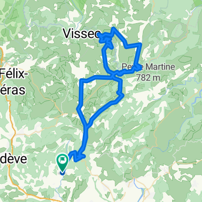
Montpeyroux - Circle through Gorges-de-l'Hérault and St-Jean-de-Buèges
Eine Fahrradroute, die in Montpeyroux, Occitanie, Frankreich beginnt.
Übersicht
Über diese Route
Das war eine sehr anspruchsvolle Fahrt. Nicht wegen der Fahrt durch die Gorges-de-l'Hérault, sondern eher die 15 bis 20 Kilometer entlang der D122. Es gab einige sehr steile Anstiege, und fast die gesamte Straße war einspurig, gelegentlich ein wenig steinig und nicht in gutem Zustand. Wir fuhren dies Ende Oktober 2024; hoffentlich wird es irgendwann neu asphaltiert.
Wenn du bereit für die D122 bist, wirst du die Landschaft und die Herausforderung genießen. Insgesamt eine großartige Fahrt.
Wir hatten sehr wenig oder gar keinen Verkehr auf allen Straßen. Da es Ende Oktober war, gab es nur sehr wenige Besucher in den Gorges. Wahrscheinlich hätte dieser Teil der Fahrt im Sommer viel mehr Verkehr.
- 4 h 45 min
- Dauer
- 51,4 km
- Distanz
- 969 m
- Aufstieg
- 979 m
- Abstieg
- 10,8 km/h
- Ø-Tempo
- 563 m
- Max. Höhe

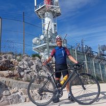
Fotos von der Route


Routenqualität
Wegtypen und Untergründe entlang der Route
Wegtypen
Straße
30,8 km
(60 %)
Ruhige Straße
0,5 km
(1 %)
Undefiniert
20 km
(39 %)
Untergründe
Befestigt
22,1 km
(43 %)
Asphalt
22,1 km
(43 %)
Undefiniert
29,3 km
(57 %)
Weiter mit Bikemap
Diese Radroute verwenden, bearbeiten oder herunterladen
Du möchtest Montpeyroux - Circle through Gorges-de-l'Hérault and St-Jean-de-Buèges fahren oder sie für deine eigene Reise anpassen? Folgendes kannst du mit dieser Bikemap-Route machen:
Gratis Funktionen
- Speichere diese Route als Favorit oder in einer Sammlung
- Kopiere & plane deine eigene Version dieser Route
- Synchronisiere deine Route mit Garmin oder Wahoo
Premium-Funktionen
Kostenlose Testversion für 3 Tage oder einmalige Zahlung. Mehr über Bikemap Premium.
- Navigiere diese Route auf iOS & Android
- Exportiere eine GPX / KML-Datei dieser Route
- Erstelle deinen individuellen Ausdruck (Jetzt kostenlos ausprobieren)
- Lade diese Route für die Offline-Navigation herunter
Entdecke weitere Premium-Funktionen.
Bikemap Premium aktivierenVon unserer Community
Montpeyroux: Andere beliebte Routen, die hier beginnen
 Montpeyroux - Circle through Gorges-de-l'Hérault and St-Jean-de-Buèges
- Distanz
- 51,4 km
- Aufstieg
- 969 m
- Abstieg
- 979 m
- Standort
- Montpeyroux, Occitanie, Frankreich
 GTH 07. Arboras Le Caylar retour 72km
- Distanz
- 73,8 km
- Aufstieg
- 971 m
- Abstieg
- 954 m
- Standort
- Montpeyroux, Occitanie, Frankreich
 GIGNAC CIRQUE VISSEC
- Distanz
- 93,7 km
- Aufstieg
- 1.472 m
- Abstieg
- 1.461 m
- Standort
- Montpeyroux, Occitanie, Frankreich
 ASCENSO AL MONT-SAINT-BAUDILLE
- Distanz
- 3,2 km
- Aufstieg
- 169 m
- Abstieg
- 39 m
- Standort
- Montpeyroux, Occitanie, Frankreich
 Cirque Navacelles 2
- Distanz
- 89,5 km
- Aufstieg
- 1.540 m
- Abstieg
- 1.543 m
- Standort
- Montpeyroux, Occitanie, Frankreich
 MUC Cyclo-Portée du 4 juin 2014
- Distanz
- 68,1 km
- Aufstieg
- 987 m
- Abstieg
- 987 m
- Standort
- Montpeyroux, Occitanie, Frankreich
 Etape 07 – De La Font du Griffe à La Vernède
- Distanz
- 31,2 km
- Aufstieg
- 865 m
- Abstieg
- 560 m
- Standort
- Montpeyroux, Occitanie, Frankreich
 Montpeyroux to Lodève
- Distanz
- 24,3 km
- Aufstieg
- 172 m
- Abstieg
- 181 m
- Standort
- Montpeyroux, Occitanie, Frankreich
In der App öffnen