

(Map 2) The Laneways of Kogarah
Eine Fahrradroute, die in Brighton-Le-Sands, New South Wales, Australien beginnt.
Übersicht
Über diese Route
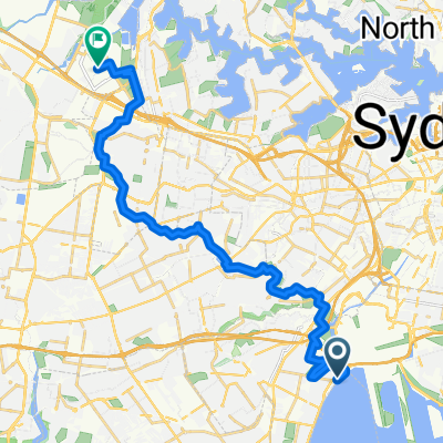
Die Gassen von Kogarah haben das Potenzial, nützliche aktive Transportverbindungen rund um das Stadtzentrum von Kogarah bereitzustellen.
Die Gassen weisen minimalen Autoverkehr auf und kreuzen Cafés, Pubs, die Bibliothek und die Überführung der Princess Highway, die über die President Ave mit dem aktiven Transport-Link M6 Stage 1 / Kamay Greenway verbunden wird.
In ihrem aktuellen Zustand lenken die Gassen den Verkehr einseitig, aber hoffentlich können sie in Zukunft als Gegenverkehrs-Fahrradwege genutzt werden.
- 8 min
- Dauer
- 2,2 km
- Distanz
- 7 m
- Aufstieg
- 8 m
- Abstieg
- 16 km/h
- Ø-Tempo
- 32 m
- Max. Höhe

Weiter mit Bikemap
Diese Radroute verwenden, bearbeiten oder herunterladen
Du möchtest (Map 2) The Laneways of Kogarah fahren oder sie für deine eigene Reise anpassen? Folgendes kannst du mit dieser Bikemap-Route machen:
Gratis Funktionen
- Speichere diese Route als Favorit oder in einer Sammlung
- Kopiere & plane deine eigene Version dieser Route
- Synchronisiere deine Route mit Garmin oder Wahoo
Premium-Funktionen
Kostenlose Testversion für 3 Tage oder einmalige Zahlung. Mehr über Bikemap Premium.
- Navigiere diese Route auf iOS & Android
- Exportiere eine GPX / KML-Datei dieser Route
- Erstelle deinen individuellen Ausdruck (Jetzt kostenlos ausprobieren)
- Lade diese Route für die Offline-Navigation herunter
Entdecke weitere Premium-Funktionen.
Bikemap Premium aktivierenVon unserer Community
Brighton-Le-Sands: Andere beliebte Routen, die hier beginnen
 The Grand Parade, Brighton-Le-Sands to 13-17 Coast Avenue, Cronulla
- Distanz
- 16,6 km
- Aufstieg
- 0 m
- Abstieg
- 6 m
- Standort
- Brighton-Le-Sands, New South Wales, Australien
 326 Bay St, Brighton-Le-Sands to 3-11 Primrose Ave, Rosebery
- Distanz
- 10,8 km
- Aufstieg
- 58 m
- Abstieg
- 44 m
- Standort
- Brighton-Le-Sands, New South Wales, Australien
 Brighton-Le-sands to Sydney Olympic Park
- Distanz
- 26,7 km
- Aufstieg
- 89 m
- Abstieg
- 77 m
- Standort
- Brighton-Le-Sands, New South Wales, Australien
 Cook Park Trail, Brighton-Le-Sands to 9 Poole Street, Kingsgrove
- Distanz
- 7,9 km
- Aufstieg
- 0 m
- Abstieg
- 3 m
- Standort
- Brighton-Le-Sands, New South Wales, Australien
 Brighton-Le-sands/route in Kyeemagh 28/9/19
- Distanz
- 18,4 km
- Aufstieg
- 40 m
- Abstieg
- 40 m
- Standort
- Brighton-Le-Sands, New South Wales, Australien
 Cook Park Trail, Brighton-Le-Sands to Spark Lane, Wolli Creek
- Distanz
- 7,6 km
- Aufstieg
- 3 m
- Abstieg
- 6 m
- Standort
- Brighton-Le-Sands, New South Wales, Australien
 1A Roslyn Avenue, Brighton-Le-Sands to 1A Roslyn Avenue, Brighton-Le-Sands
- Distanz
- 13,3 km
- Aufstieg
- 9 m
- Abstieg
- 17 m
- Standort
- Brighton-Le-Sands, New South Wales, Australien
 Cook Park Path, Kyeemagh to Sydney Olympic Park
- Distanz
- 26,7 km
- Aufstieg
- 141 m
- Abstieg
- 130 m
- Standort
- Brighton-Le-Sands, New South Wales, Australien
In der App öffnen