![(Map 3) M5 Linear Park (Kingsgrove) to Bexley [via Bexley North]](/_next/static/media/contour-lines-light-small.cafd5e5d.avif)
![(Map 3) M5 Linear Park (Kingsgrove) to Bexley [via Bexley North]](https://media.bikemap.net/routes/15929589/staticmaps/in_a8a15940-1200-41d0-a1ed-7ff8b7b97ec0_694x400_bikemap-2021-3D-static.png)
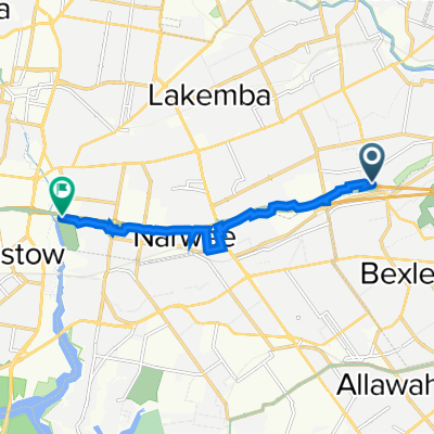
(Map 3) M5 Linear Park (Kingsgrove) to Bexley [via Bexley North]
Eine Fahrradroute, die in Bexley North, New South Wales, Australien beginnt.
Übersicht
Über diese Route
Diese Route verbindet den M5 Linear Park mit dem Bexley Bike Bus (Karte 1) über Gassen und ruhige Wohnstraßen.
Siehe (Karte 3D) für vorgeschlagene Verbesserungen dieser Route, die vom Bayside Council und der Regierung von NSW umgesetzt werden sollen.
- 14 min
- Dauer
- 3,6 km
- Distanz
- 31 m
- Aufstieg
- 4 m
- Abstieg
- 15,1 km/h
- Ø-Tempo
- 45 m
- Max. Höhe

Routenqualität
Wegtypen und Untergründe entlang der Route
Wegtypen
Ruhige Straße
2,1 km
(58 %)
Fußgängerzone
0,3 km
(9 %)
Untergründe
Befestigt
3 km
(83 %)
Befestigt (undefiniert)
2 km
(55 %)
Asphalt
1 km
(28 %)
Undefiniert
0,6 km
(17 %)
Weiter mit Bikemap
Diese Radroute verwenden, bearbeiten oder herunterladen
Du möchtest (Map 3) M5 Linear Park (Kingsgrove) to Bexley [via Bexley North] fahren oder sie für deine eigene Reise anpassen? Folgendes kannst du mit dieser Bikemap-Route machen:
Gratis Funktionen
- Speichere diese Route als Favorit oder in einer Sammlung
- Kopiere & plane deine eigene Version dieser Route
- Synchronisiere deine Route mit Garmin oder Wahoo
Premium-Funktionen
Kostenlose Testversion für 3 Tage oder einmalige Zahlung. Mehr über Bikemap Premium.
- Navigiere diese Route auf iOS & Android
- Exportiere eine GPX / KML-Datei dieser Route
- Erstelle deinen individuellen Ausdruck (Jetzt kostenlos ausprobieren)
- Lade diese Route für die Offline-Navigation herunter
Entdecke weitere Premium-Funktionen.
Bikemap Premium aktivierenVon unserer Community
Bexley North: Andere beliebte Routen, die hier beginnen
 Miller Avenue 16, Bexley North to Golden Vale Road, Sutton Forest
- Distanz
- 132 km
- Aufstieg
- 2.182 m
- Abstieg
- 1.566 m
- Standort
- Bexley North, New South Wales, Australien
 Bexley North to Salt Pan Creek Reserve (M5 East Tunnel Cycleway)
- Distanz
- 8,4 km
- Aufstieg
- 54 m
- Abstieg
- 67 m
- Standort
- Bexley North, New South Wales, Australien
 Clemton Park to Lakemba
- Distanz
- 3,4 km
- Aufstieg
- 44 m
- Abstieg
- 29 m
- Standort
- Bexley North, New South Wales, Australien
 cooks River home loop
- Distanz
- 10,2 km
- Aufstieg
- 146 m
- Abstieg
- 139 m
- Standort
- Bexley North, New South Wales, Australien
 Bexley North - Home
- Distanz
- 4,9 km
- Aufstieg
- 57 m
- Abstieg
- 28 m
- Standort
- Bexley North, New South Wales, Australien
 Bexley Rd, Kingsgrove to 3 The Crescent, Kingsgrove
- Distanz
- 4,7 km
- Aufstieg
- 30 m
- Abstieg
- 18 m
- Standort
- Bexley North, New South Wales, Australien
 9 Calbina Road, Earlwood to 13 Calbina Road, Earlwood
- Distanz
- 22,6 km
- Aufstieg
- 34 m
- Abstieg
- 57 m
- Standort
- Bexley North, New South Wales, Australien
 Bexley North to Cooks River
- Distanz
- 3,7 km
- Aufstieg
- 32 m
- Abstieg
- 45 m
- Standort
- Bexley North, New South Wales, Australien
In der App öffnen