

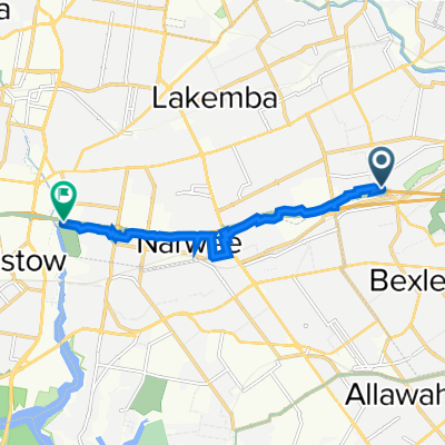
Bexley North to Cooks River
Eine Fahrradroute, die in Bexley North, New South Wales, Australien beginnt.
Übersicht
Über diese Route
- 14 min
- Dauer
- 3,7 km
- Distanz
- 32 m
- Aufstieg
- 45 m
- Abstieg
- 15,4 km/h
- Ø-Tempo
- 47 m
- Max. Höhe

Routenqualität
Wegtypen und Untergründe entlang der Route
Wegtypen
Radweg
1,7 km
(45 %)
Ruhige Straße
1,4 km
(37 %)
Untergründe
Befestigt
3,2 km
(86 %)
Befestigt (undefiniert)
1,6 km
(43 %)
Beton
0,9 km
(25 %)
Weiter mit Bikemap
Diese Radroute verwenden, bearbeiten oder herunterladen
Du möchtest Bexley North to Cooks River fahren oder sie für deine eigene Reise anpassen? Folgendes kannst du mit dieser Bikemap-Route machen:
Gratis Funktionen
- Speichere diese Route als Favorit oder in einer Sammlung
- Kopiere & plane deine eigene Version dieser Route
- Synchronisiere deine Route mit Garmin oder Wahoo
Premium-Funktionen
Kostenlose Testversion für 3 Tage oder einmalige Zahlung. Mehr über Bikemap Premium.
- Navigiere diese Route auf iOS & Android
- Exportiere eine GPX / KML-Datei dieser Route
- Erstelle deinen individuellen Ausdruck (Jetzt kostenlos ausprobieren)
- Lade diese Route für die Offline-Navigation herunter
Entdecke weitere Premium-Funktionen.
Bikemap Premium aktivierenVon unserer Community
Bexley North: Andere beliebte Routen, die hier beginnen
 Bexley North to Salt Pan Creek Reserve (M5 East Tunnel Cycleway)
- Distanz
- 8,4 km
- Aufstieg
- 54 m
- Abstieg
- 67 m
- Standort
- Bexley North, New South Wales, Australien
 cooks River home loop
- Distanz
- 10,2 km
- Aufstieg
- 146 m
- Abstieg
- 139 m
- Standort
- Bexley North, New South Wales, Australien
 Bexley North to Cooks River
- Distanz
- 3,7 km
- Aufstieg
- 32 m
- Abstieg
- 45 m
- Standort
- Bexley North, New South Wales, Australien
 63 Shaw Street, Bexley North to 29 Fletcher Street, Campsie
- Distanz
- 3,7 km
- Aufstieg
- 42 m
- Abstieg
- 22 m
- Standort
- Bexley North, New South Wales, Australien
 9 Calbina Road, Earlwood to 13 Calbina Road, Earlwood
- Distanz
- 22,6 km
- Aufstieg
- 34 m
- Abstieg
- 57 m
- Standort
- Bexley North, New South Wales, Australien
 Bexley North - Home
- Distanz
- 4,9 km
- Aufstieg
- 57 m
- Abstieg
- 28 m
- Standort
- Bexley North, New South Wales, Australien
 Miller Avenue 16, Bexley North to Golden Vale Road, Sutton Forest
- Distanz
- 132 km
- Aufstieg
- 2.182 m
- Abstieg
- 1.566 m
- Standort
- Bexley North, New South Wales, Australien
 Clemton Park to Lakemba
- Distanz
- 3,4 km
- Aufstieg
- 44 m
- Abstieg
- 29 m
- Standort
- Bexley North, New South Wales, Australien
In der App öffnen