

Via Transilvanica, Section 3: Terra Siculorum (official)
Eine Fahrradroute, die in Eremitu, Kreis Mieresch, Rumänien beginnt.
Übersicht
Über diese Route
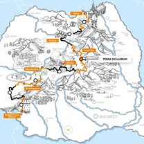
Terra Siculorum is the Latin name for Szeklerland, a region of Romania that plays a significant role in shaping the ethnic, cultural, and historical layers of Via Transilvanica (VT). Along this section, the Szekler communities stand out with their distinctive character, as does the natural landscape, featuring vast pastures, gentle hills, flowering meadows, and rich forests of beech, pine, and spruce. Some of the key highlights of this section include the excellent pălinca, delicious lángos, salt mountains, the Hungarian language, traditional handicrafts, a deep love and care for horses, captivating stories, and an abundance of tasty food. We uncover the ancient runic script, the Szeklers' distinctive mustaches, their traditional attire, intricately carved Szekler gates, grand celebrations with their characteristic folk dances, and homemade potato bread. Fierce guardians of Szekler customs, traditions, and culture, the people are exceptionally hospitable and endlessly cheerful. More details:https://www.viatransilvanica.com/en/
- -:--
- Dauer
- 150,8 km
- Distanz
- 3.916 m
- Aufstieg
- 4.072 m
- Abstieg
- ---
- Ø-Tempo
- 1.036 m
- Max. Höhe

Fotos von der Route
\"")
\"")
\"")
\"")
\"")
\"")
Routenqualität
Wegtypen und Untergründe entlang der Route
Wegtypen
Forst- / Feldweg
58,6 km
(39 %)
Ruhige Straße
40,4 km
(27 %)
Untergründe
Befestigt
25,5 km
(17 %)
Unbefestigt
37,4 km
(25 %)
Schotter
28,8 km
(19 %)
Asphalt
25,2 km
(17 %)
Weiter mit Bikemap
Diese Radroute verwenden, bearbeiten oder herunterladen
Du möchtest Via Transilvanica, Section 3: Terra Siculorum (official) fahren oder sie für deine eigene Reise anpassen? Folgendes kannst du mit dieser Bikemap-Route machen:
Gratis Funktionen
- Speichere diese Route als Favorit oder in einer Sammlung
- Kopiere & plane deine eigene Version dieser Route
- Teile sie in Etappen ein, um eine mehrtägige Tour zu erstellen
- Synchronisiere deine Route mit Garmin oder Wahoo
Premium-Funktionen
Kostenlose Testversion für 3 Tage oder einmalige Zahlung. Mehr über Bikemap Premium.
- Navigiere diese Route auf iOS & Android
- Exportiere eine GPX / KML-Datei dieser Route
- Erstelle deinen individuellen Ausdruck (Jetzt kostenlos ausprobieren)
- Lade diese Route für die Offline-Navigation herunter
Entdecke weitere Premium-Funktionen.
Bikemap Premium aktivierenVon unserer Community
Eremitu: Andere beliebte Routen, die hier beginnen
 9.nap- május 11. péntek - Gurul a Rádió (2012)
- Distanz
- 48,7 km
- Aufstieg
- 133 m
- Abstieg
- 413 m
- Standort
- Eremitu, Kreis Mieresch, Rumänien
 Via Transilvanica - Terra Siculorum
- Distanz
- 150,3 km
- Aufstieg
- ---
- Abstieg
- ---
- Standort
- Eremitu, Kreis Mieresch, Rumänien
 Tompa tető - Pogor hegy - Marosvásárhely
- Distanz
- 38,5 km
- Aufstieg
- 127 m
- Abstieg
- 331 m
- Standort
- Eremitu, Kreis Mieresch, Rumänien
 Traseu lung - Saca Mare - Campu Cetatii
- Distanz
- 43,3 km
- Aufstieg
- 1.182 m
- Abstieg
- 1.182 m
- Standort
- Eremitu, Kreis Mieresch, Rumänien
 c.cetatii forest
- Distanz
- 10,8 km
- Aufstieg
- 203 m
- Abstieg
- 309 m
- Standort
- Eremitu, Kreis Mieresch, Rumänien
- Via Transilvanica, Section 3: Terra Siculorum (official)
- Distanz
- 150,8 km
- Aufstieg
- 3.916 m
- Abstieg
- 4.072 m
- Standort
- Eremitu, Kreis Mieresch, Rumänien
 SZT.2N - Varmezo - 2. nap
- Distanz
- 59,9 km
- Aufstieg
- 1.447 m
- Abstieg
- 1.448 m
- Standort
- Eremitu, Kreis Mieresch, Rumänien
 Traseu scurt - Campu Cetatii
- Distanz
- 31,6 km
- Aufstieg
- 714 m
- Abstieg
- 712 m
- Standort
- Eremitu, Kreis Mieresch, Rumänien
In der App öffnen