

Via Transilvanica, Section 6: Terra Banatica (official)
Eine Fahrradroute, die in Bucova, Kreis Caraș-Severin, Rumänien beginnt.
Übersicht
Über diese Route
Caraș-Severin ist der Landkreis, in dem 15 ethnische Minderheiten leben (Rumänen, Ungarn, Deutsche, Kroaten, Serben, Roma, Tschechen, Slowaken, Ukrainer, Lipovaner Russen, Türken, Bulgaren, Juden, Polen und Italiener). Es ist ein bemerkenswertes Beispiel für friedliches Zusammenleben und den Erhalt der Sprache und Traditionen jeder Gemeinschaft, was bei jeder lokalen Feier zum Ausdruck kommt. Terra Banatica, ein riesiges hydrologisches Becken, in dem die Wasser aller Berggipfel zusammenfließen, ist das Land der rauschenden Flüsse, Thermalquellen, lebendig grüner Moose, Wassermühlen, verzauberter Blumenwiesen, scharfer grauer Klippen, geheimnisvoller Höhlen, uralter Buchenwälder und Geisterdörfer – ein magisches Reich. Hier herrscht die Natur mit kleinen Dörfern und nur wenigen größeren Städten entlang des Weges vor. Doch die Herzlichkeit der Menschen, ihre răchia (traditioneller Brandy), die Ruhe des Landes und der unverkennbare „Banater Dialekt“ machen die Reise besonders. Die Zivilisation ist spärlich, das Telefonsignal schwach, aber die Möglichkeit zur innigen Reflexion ist reichlich. Die langen, weiten Pfade laden zu unzähligen inneren und äußeren Entdeckungen ein. Terra Banatica ist ein Land, in dem viele Geschichten entstanden sind, die darauf warten, vom Wind geflüstert zu werden, wenn er durch ein Meer von Wildblumen, zitronen-duftendem Thymian und jahrhundertealten Buchenbäumen rauscht. Weitere Informationen: https://www.viatransilvanica.com/en/
- -:--
- Dauer
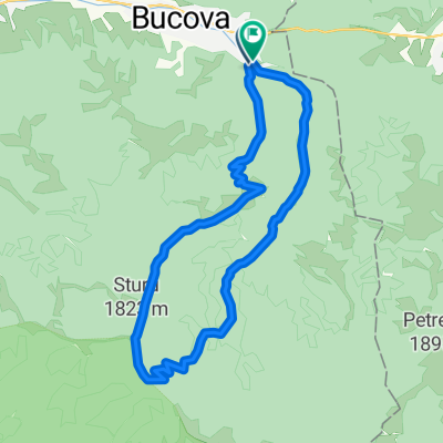
- 237,1 km
- Distanz
- 6.332 m
- Aufstieg
- 6.696 m
- Abstieg
- ---
- Ø-Tempo
- 1.201 m
- Max. Höhe

Fotos von der Route
\"")
\"")
\"")
\"")
\"")
Routenqualität
Wegtypen und Untergründe entlang der Route
Wegtypen
Forst- / Feldweg
135,2 km
(57 %)
Ruhige Straße
66,4 km
(28 %)
Untergründe
Befestigt
33,2 km
(14 %)
Unbefestigt
109,1 km
(46 %)
Unbefestigt (undefiniert)
56,9 km
(24 %)
Schotter
30,8 km
(13 %)
Weiter mit Bikemap
Diese Radroute verwenden, bearbeiten oder herunterladen
Du möchtest Via Transilvanica, Section 6: Terra Banatica (official) fahren oder sie für deine eigene Reise anpassen? Folgendes kannst du mit dieser Bikemap-Route machen:
Gratis Funktionen
- Speichere diese Route als Favorit oder in einer Sammlung
- Kopiere & plane deine eigene Version dieser Route
- Teile sie in Etappen ein, um eine mehrtägige Tour zu erstellen
- Synchronisiere deine Route mit Garmin oder Wahoo
Premium-Funktionen
Kostenlose Testversion für 3 Tage oder einmalige Zahlung. Mehr über Bikemap Premium.
- Navigiere diese Route auf iOS & Android
- Exportiere eine GPX / KML-Datei dieser Route
- Erstelle deinen individuellen Ausdruck (Jetzt kostenlos ausprobieren)
- Lade diese Route für die Offline-Navigation herunter
Entdecke weitere Premium-Funktionen.
Bikemap Premium aktivierenVon unserer Community
Bucova: Andere beliebte Routen, die hier beginnen
 Bucova , Preveciori 2
- Distanz
- 20,6 km
- Aufstieg
- 656 m
- Abstieg
- 846 m
- Standort
- Bucova, Kreis Caraș-Severin, Rumänien
 tarcu pe sus
- Distanz
- 52,8 km
- Aufstieg
- 1.955 m
- Abstieg
- 1.955 m
- Standort
- Bucova, Kreis Caraș-Severin, Rumänien
 Bucova , Varful Sturu
- Distanz
- 24,7 km
- Aufstieg
- 1.189 m
- Abstieg
- 1.200 m
- Standort
- Bucova, Kreis Caraș-Severin, Rumänien
 via trans 1
- Distanz
- 31,8 km
- Aufstieg
- 207 m
- Abstieg
- 401 m
- Standort
- Bucova, Kreis Caraș-Severin, Rumänien
 Bucova-Preveciori
- Distanz
- 39,3 km
- Aufstieg
- 902 m
- Abstieg
- 902 m
- Standort
- Bucova, Kreis Caraș-Severin, Rumänien
- Via Transilvanica, Section 6: Terra Banatica (official)
- Distanz
- 237,1 km
- Aufstieg
- 6.332 m
- Abstieg
- 6.696 m
- Standort
- Bucova, Kreis Caraș-Severin, Rumänien
 Via Transilvanica - Terra Banatica
- Distanz
- 230,1 km
- Aufstieg
- ---
- Abstieg
- ---
- Standort
- Bucova, Kreis Caraș-Severin, Rumänien
 Via Transilvanica via Poiana Marului
- Distanz
- 324,6 km
- Aufstieg
- 3.452 m
- Abstieg
- 3.818 m
- Standort
- Bucova, Kreis Caraș-Severin, Rumänien
In der App öffnen