

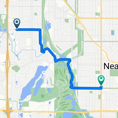
Theo Wirth Area MTB Trails
Eine Fahrradroute, die in Golden Valley, Minnesota, Vereinigte Staaten beginnt.
Übersicht
Über diese Route
Dies ist eine gute MTB-Route, die alle Dirt Trails im Theo Wirth Gebiet abdeckt. Sie beginnt in Robbinsdale und führt nach Süden bis zum Cedar Lake und dann wieder zurück. Es gibt eine schöne Mischung aus unbefestigten und asphaltierten Wegen.
- -:--
- Dauer
- 14,8 km
- Distanz
- 81 m
- Aufstieg
- 93 m
- Abstieg
- ---
- Ø-Tempo
- ---
- Max. Höhe
Highlights der Route
POIs entlang der Route
Interessanter Ort nach 0 km
This is the parking lot for the Mary Hills Park. There is a field right next to the parking lot. The single track starts at the southern end of this field and goes all the way through the park down to Golden Valley Road. Cross Golden Valley Road and another trail picks up right next to the golf course. Look out for walkers.
Interessanter Ort nach 1,1 km
Sweet dirt jump area!
Interessanter Ort nach 2,1 km
This trail is short but fun. It is much better coming from the north and heading south. Look out for walkers.
Interessanter Ort nach 3,5 km
Theo Wirth Singletrack North Loop Entrance.
Interessanter Ort nach 3,8 km
Theo Wirth Singletrack South Loop Entrance.
Interessanter Ort nach 4,3 km
This is a nice quick little single track that leads down to the paved trail that goes around Wirth Lake. Once you hit the paved trail, go to your right and look for a single track trail exit on your right. This will lead you back out to Wirth Parkway where you can cross the street and the trail continues.
Interessanter Ort nach 5 km
This is a fun little trail that offers a steep climb if heading south and a fun downhill with a nice drop if heading north.
Interessanter Ort nach 6,8 km
Check out the very technical Brownie Lake singletrack in these woods. Lots of quick ups and downs.
Interessanter Ort nach 8,7 km
This is a nice little secluded area with some good dirt jumps and lots of trails intersecting. Look out for walkers through here though. Technically bikes are not allowed on these trails but people do not seem to mind as long your not speeding through here. There is also an older technical trail with a teeter totter and some log piles right next to the train tracks.
Interessanter Ort nach 9,7 km
This area as well as the Cedar Lake area has a ton of older trails. They are nothing to write home about but fun to explore.
Interessanter Ort nach 11,3 km
There are some more older trails and berms in here. These are the Hobo Camp trails.
Weiter mit Bikemap
Diese Radroute verwenden, bearbeiten oder herunterladen
Du möchtest Theo Wirth Area MTB Trails fahren oder sie für deine eigene Reise anpassen? Folgendes kannst du mit dieser Bikemap-Route machen:
Gratis Funktionen
- Speichere diese Route als Favorit oder in einer Sammlung
- Kopiere & plane deine eigene Version dieser Route
- Synchronisiere deine Route mit Garmin oder Wahoo
Premium-Funktionen
Kostenlose Testversion für 3 Tage oder einmalige Zahlung. Mehr über Bikemap Premium.
- Navigiere diese Route auf iOS & Android
- Exportiere eine GPX / KML-Datei dieser Route
- Erstelle deinen individuellen Ausdruck (Jetzt kostenlos ausprobieren)
- Lade diese Route für die Offline-Navigation herunter
Entdecke weitere Premium-Funktionen.
Bikemap Premium aktivierenVon unserer Community
Golden Valley: Andere beliebte Routen, die hier beginnen
 B2B00321 55442>55411 via Culver Rd, Kyle Ave, Theo Wirth Pkwy & Plymouth Ave
- Distanz
- 5 km
- Aufstieg
- 37 m
- Abstieg
- 37 m
- Standort
- Golden Valley, Minnesota, Vereinigte Staaten
 6/28/19
- Distanz
- 17,9 km
- Aufstieg
- 74 m
- Abstieg
- 77 m
- Standort
- Golden Valley, Minnesota, Vereinigte Staaten
 44 Mile Tour D'Amico
- Distanz
- 66,9 km
- Aufstieg
- 201 m
- Abstieg
- 201 m
- Standort
- Golden Valley, Minnesota, Vereinigte Staaten
 Theo Wirth Area MTB Trails
- Distanz
- 14,8 km
- Aufstieg
- 81 m
- Abstieg
- 93 m
- Standort
- Golden Valley, Minnesota, Vereinigte Staaten
 B2B00088 55411 > 55111 via downtown, Light Rail trail, and Minnehaha park
- Distanz
- 18,8 km
- Aufstieg
- 39 m
- Abstieg
- 95 m
- Standort
- Golden Valley, Minnesota, Vereinigte Staaten
 Trip to Wayzata
- Distanz
- 18,8 km
- Aufstieg
- 108 m
- Abstieg
- 76 m
- Standort
- Golden Valley, Minnesota, Vereinigte Staaten
 Loop 5/20/20
- Distanz
- 14,8 km
- Aufstieg
- 95 m
- Abstieg
- 93 m
- Standort
- Golden Valley, Minnesota, Vereinigte Staaten
 edina route66
- Distanz
- 46,2 km
- Aufstieg
- 116 m
- Abstieg
- 117 m
- Standort
- Golden Valley, Minnesota, Vereinigte Staaten
In der App öffnen