

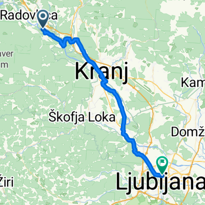
Day 6 | Radovljica to Kranjska Gora
Eine Fahrradroute, die in Radovljica, Radmannsdorf, Slowenien beginnt.
Übersicht
Über diese Route
Startpunkt: Ihr Hotel Zeitplanung: ganzer Tag Essen und Trinken: unterwegs viele Möglichkeiten An einem Regentag: 1. Öffentliche Verkehrsmittel: Sie können den Zug von der Station Radovljica nach Jesenice nehmen. 2. Taxi: Wir arrangieren gerne ein Taxi für Sie. Zusätzliche Gebühren fallen entsprechend an. Diese Route führt Sie entlang des Kamnik-Savinja-Alpenrands zum historischen Dorf Begunje. In dieser kleinen Siedlung ereignete sich einer der dunkelsten Momente Sloweniens. Besuchen Sie das Museum der Geiseln und erfahren Sie, wie Tausende von Männern, Frauen und Kindern während der deutschen Besetzung im Zweiten Weltkrieg misshandelt und hingerichtet wurden. Auf einer leichteren Note ist Begunje auch die Heimat der berühmten Slavko Avsenik / Oberkrainer-Band. 2 km die Straße hinunter liegen die Ruinen der Burg Kamen. Während die Sonne die Berge erleuchtet, führt Ihre Route auf einem Radweg, der zwischen den Gipfeln der Julischen Alpen und den Karawanken in den beliebten Wintersportort Kranjska Gora verläuft, der auch eine großartige Basis für viele Sommeraktivitäten ist. Wenn Sie rechtzeitig ankommen, können Sie eine Fahrt ins Planica-Tal unternehmen, den Austragungsort der weltberühmten Skisprungmeisterschaften. Hier wurden viele der längsten Sprünge erzielt, einschließlich des aktuellen Weltrekords.
- 3 h 30 min
- Dauer
- 49,4 km
- Distanz
- 871 m
- Aufstieg
- 551 m
- Abstieg
- 14,1 km/h
- Ø-Tempo
- 812 m
- Max. Höhe
Weiter mit Bikemap
Diese Radroute verwenden, bearbeiten oder herunterladen
Du möchtest Day 6 | Radovljica to Kranjska Gora fahren oder sie für deine eigene Reise anpassen? Folgendes kannst du mit dieser Bikemap-Route machen:
Gratis Funktionen
- Speichere diese Route als Favorit oder in einer Sammlung
- Kopiere & plane deine eigene Version dieser Route
- Synchronisiere deine Route mit Garmin oder Wahoo
Premium-Funktionen
Kostenlose Testversion für 3 Tage oder einmalige Zahlung. Mehr über Bikemap Premium.
- Navigiere diese Route auf iOS & Android
- Exportiere eine GPX / KML-Datei dieser Route
- Erstelle deinen individuellen Ausdruck (Jetzt kostenlos ausprobieren)
- Lade diese Route für die Offline-Navigation herunter
Entdecke weitere Premium-Funktionen.
Bikemap Premium aktivierenVon unserer Community
Radovljica: Andere beliebte Routen, die hier beginnen
 Jesenice - Sv. Duh
- Distanz
- 47,6 km
- Aufstieg
- 494 m
- Abstieg
- 602 m
- Standort
- Radovljica, Radmannsdorf, Slowenien
 bike tour from 2. maj 17:16
- Distanz
- 24,6 km
- Aufstieg
- 548 m
- Abstieg
- 548 m
- Standort
- Radovljica, Radmannsdorf, Slowenien
 2016 bike tour opening
- Distanz
- 20,5 km
- Aufstieg
- 575 m
- Abstieg
- 575 m
- Standort
- Radovljica, Radmannsdorf, Slowenien
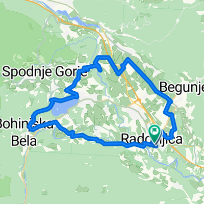
 Eco River camp (Radovljica)-Natura Eco camp (Kranjska Gora) 50 km
- Distanz
- 49,5 km
- Aufstieg
- 1.047 m
- Abstieg
- 650 m
- Standort
- Radovljica, Radmannsdorf, Slowenien
 slap peracica
- Distanz
- 12,5 km
- Aufstieg
- 227 m
- Abstieg
- 199 m
- Standort
- Radovljica, Radmannsdorf, Slowenien
 Entlang der Sava nach Bled
- Distanz
- 33,8 km
- Aufstieg
- 556 m
- Abstieg
- 557 m
- Standort
- Radovljica, Radmannsdorf, Slowenien
 Radovljica - Uskovnica - Savica - Boh. Bistrica
- Distanz
- 64,3 km
- Aufstieg
- 1.084 m
- Abstieg
- 1.063 m
- Standort
- Radovljica, Radmannsdorf, Slowenien
 Radovljica - Mojstrana - Radovna - Radovljica
- Distanz
- 55,4 km
- Aufstieg
- 586 m
- Abstieg
- 586 m
- Standort
- Radovljica, Radmannsdorf, Slowenien
In der App öffnen