

Frimley To Oldbury Pt2
Eine Fahrradroute, die in Northampton, England, Vereinigtes Königreich beginnt.
Übersicht
Über diese Route
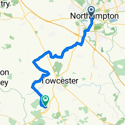
from the Travelodge in Northampton return to the Northampton arm of the Grand Union Canal and join the Grand Union going north.
Continue to Braunston( there is a tunnel just before Braunston which means you have to leave the canal...I nearly got lost here because the link back is not sign posted..Check on Google maps to familiarize yourself with its patht) and take the Oxford Canal, west. Follow to Napton Juction and take the Grand Union, north to Kingswood(tunnel at Shrewley). Join The Stratford Upon Avon canal going north to its juction with the Worcester and Birmingham Canal ( there is also a tunnel just before this junction that means you have to leave the canal..again the link back is not sign posted so check on google maps.), continue Noth to Gas St Basin. Join the Birmingham Canal Navigations going north west to the Birmingham Canal (old main line)..take this to its road juction with Churchbridge.
Join main road to Travelodge at Oldbury, B69 2BH
- -:--
- Dauer
- 115,9 km
- Distanz
- 282 m
- Aufstieg
- 188 m
- Abstieg
- ---
- Ø-Tempo
- ---
- Max. Höhe
Highlights der Route
POIs entlang der Route
Interessanter Ort nach 28 km
Interessanter Ort nach 30,2 km
Interessanter Ort nach 69,2 km
Superb flight of 22 or more locks
Interessanter Ort nach 73,1 km
Tunnel starts here
Interessanter Ort nach 73,4 km
route continues down side of 92 Shrewley Common
Interessanter Ort nach 73,5 km
tunnel ends here
Interessanter Ort nach 78 km
join the Straford Upon Avon Canal here
Interessanter Ort nach 96,3 km
tunnel starts here
Interessanter Ort nach 96,7 km
tunnel ends here
Interessanter Ort nach 98,1 km
Worcester and Birmingham Canal
Interessanter Ort nach 109,8 km
Birmingham (old Line)
Interessanter Ort nach 113,1 km
Old Line Crosses New Line
Weiter mit Bikemap
Diese Radroute verwenden, bearbeiten oder herunterladen
Du möchtest Frimley To Oldbury Pt2 fahren oder sie für deine eigene Reise anpassen? Folgendes kannst du mit dieser Bikemap-Route machen:
Gratis Funktionen
- Speichere diese Route als Favorit oder in einer Sammlung
- Kopiere & plane deine eigene Version dieser Route
- Teile sie in Etappen ein, um eine mehrtägige Tour zu erstellen
- Synchronisiere deine Route mit Garmin oder Wahoo
Premium-Funktionen
Kostenlose Testversion für 3 Tage oder einmalige Zahlung. Mehr über Bikemap Premium.
- Navigiere diese Route auf iOS & Android
- Exportiere eine GPX / KML-Datei dieser Route
- Erstelle deinen individuellen Ausdruck (Jetzt kostenlos ausprobieren)
- Lade diese Route für die Offline-Navigation herunter
Entdecke weitere Premium-Funktionen.
Bikemap Premium aktivierenVon unserer Community
Northampton: Andere beliebte Routen, die hier beginnen
 Northampton to Silverstone
- Distanz
- 31 km
- Aufstieg
- 244 m
- Abstieg
- 188 m
- Standort
- Northampton, England, Vereinigtes Königreich
 Spinney Hill Road 63 to Spinney Hill Road 63
- Distanz
- 24,8 km
- Aufstieg
- 193 m
- Abstieg
- 193 m
- Standort
- Northampton, England, Vereinigtes Königreich
 Fir Fun.
- Distanz
- 18,9 km
- Aufstieg
- 349 m
- Abstieg
- 354 m
- Standort
- Northampton, England, Vereinigtes Königreich
 Frimley To Oldbury Pt2
- Distanz
- 115,9 km
- Aufstieg
- 282 m
- Abstieg
- 188 m
- Standort
- Northampton, England, Vereinigtes Königreich
 Cats 11/08/10
- Distanz
- 26 km
- Aufstieg
- 164 m
- Abstieg
- 161 m
- Standort
- Northampton, England, Vereinigtes Königreich
 London Road to London Road
- Distanz
- 38,2 km
- Aufstieg
- 329 m
- Abstieg
- 339 m
- Standort
- Northampton, England, Vereinigtes Königreich
 Day 8
Day 8- Distanz
- 108 km
- Aufstieg
- 391 m
- Abstieg
- 441 m
- Standort
- Northampton, England, Vereinigtes Königreich
 Northampton 12miles 16feb14
- Distanz
- 19,4 km
- Aufstieg
- 118 m
- Abstieg
- 118 m
- Standort
- Northampton, England, Vereinigtes Königreich
In der App öffnen