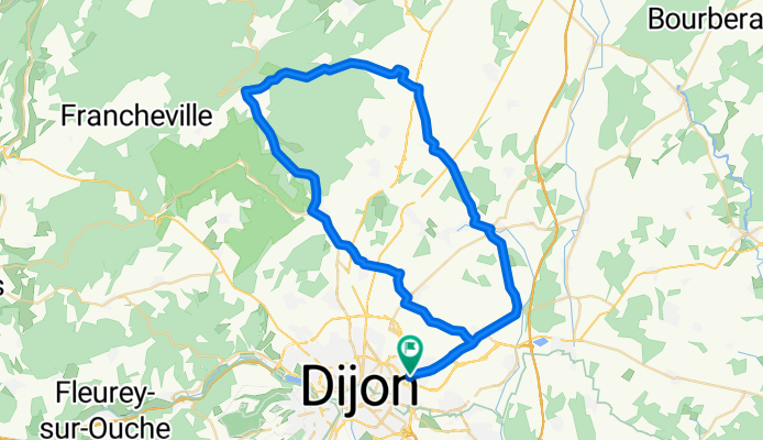


2009 Euro Tour -- Ride Day 14 — 7 July 2009 — 21850 St-Apollinaire (Dijon) -- Circle
- 60,6 km
- 461 m
- 460 m
- Saint-Apollinaire, Bourgogne-Franche-Comté, Frankreich
Eine Fahrradroute, die in Saint-Apollinaire, Bourgogne-Franche-Comté, Frankreich beginnt.
Übersicht
Wir haben beschlossen, unseren Aufenthalt in Dijon um zwei Nächte zu verlängern, sodass wir eine tolle Fahrt in die Gegend nördlich der Stadt gemacht haben. Glücklicherweise haben wir trotz der sonnigen Wettervorhersage unsere Mäntel und Regenschutzschuhe mitgenommen, da wir doch etwas Regen abbekommen haben. Nicht so schlimm wie die Durchnässung, die wir früher auf dieser Reise hatten, aber genug, um ziemlich nass zu werden.
Auf dieser Strecke war der lange 9 km Anstieg auf der D996 von etwa 300 m auf 554 m definitiv ein gutes Training.
Auf dem Rückweg konnten wir dank unseres gestern erworbenen Wissens vom Verirren den Carrefour leicht finden. So konnten wir problemlos Essen für das Abendessen und die nächsten Tage kaufen. Gestern Abend hatten wir ein eher spärliches Abendessen im Zimmer, bei dem wir die restlichen Vorräte aufgebraucht hatten. Da wir ziemlich spät ankamen, nachdem wir viel Zeit mit Radfahren in Dijon verbracht hatten, hatten wir keine Gelegenheit, vorher noch einkaufen zu gehen.
Hintergrund:
Meine Frau und ich machen seit 1993 selbstorganisierte Touren in Westeuropa (überwiegend in Frankreich). Diese Reihe von Fahrten beschreibt unsere Route von 2009, die 4,5 Monate durch Teile von Frankreich, Deutschland, Österreich, der Schweiz und zurück nach Frankreich führte. Start- und Endpunkt ist in der Nähe von Chadurie (südlich von Angoulême), wo unsere Freunde einen Bauernhof mit Gîtes und Chambres d'Hôtes haben.
Wir fuhren unsere Dawes-Tourenräder, die wir 1993 gekauft haben, stark beladen mit 700Cx32 Reifen. Unsere Fahrten fanden alle auf asphaltierten Straßen statt, meistens mit sehr wenig Verkehr. Die einzigen unbefestigten Abschnitte waren einige Fahrradwege in Deutschland und Österreich. Leider war das nicht so toll, da Helen auf den unbefestigten Wegen mehrmals gestürzt ist. Zum Glück gab es keine ernsthaften Verletzungen.
Bei Fragen können Sie mir gern eine E-Mail an jeffkadet@netdiving.com senden.
Jeff
Erstellt vor 13 Jahren
Routenqualität
Straße
21,2 km
(35 %)
Ruhige Straße
10,9 km
(18 %)
Befestigt
27,9 km
(46 %)
Asphalt
27,9 km
(46 %)
Undefiniert
32,7 km
(54 %)
Weiter mit Bikemap
Du möchtest 2009 Euro Tour -- Ride Day 14 — 7 July 2009 — 21850 St-Apollinaire (Dijon) -- Circle fahren oder sie für deine eigene Reise anpassen? Folgendes kannst du mit dieser Bikemap-Route machen:
Kostenlose Testversion für 3 Tage oder einmalige Zahlung. Mehr über Bikemap Premium.
Entdecke weitere Premium-Funktionen.
Bikemap Premium aktivierenVon unserer Community
In der App öffnen