

Star Cycles Inglewood-COP-Kersbrook
Eine Fahrradroute, die in Elizabeth, Südaustralien, Australien beginnt.
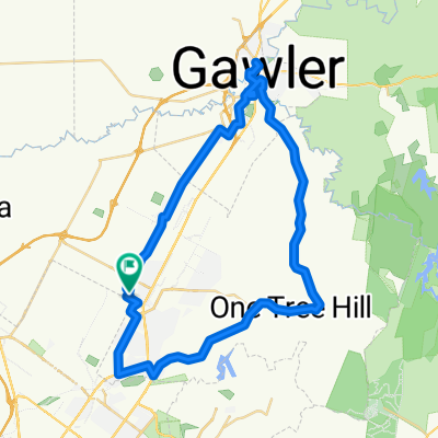
Übersicht
Über diese Route
Verlasse Star Cycles über Elizabeth Way und Philip Hwy zur John Rice Av. Rechts auf die Commercial Rd und eine Linkskurve führt uns durch Salisbury vorbei an Parabanks. Links auf Ponton St, nochmal links auf Fenden Rd, die uns auf Saints Rd bringt. Überquere die Main North Rd und fahre den Grove Way hinauf, der zur Yatala Vale Rd wird. Weiter bis zur Seaview Rd, wo eine Linkskurve uns zur Range Rd North führt. Ein mäßiger Anstieg bringt uns zur Lower North East Rd, wo eine Linkskurve unsere Gruppe durch Inglewood, Chain of Ponds und Kersbrook führt. Unsere Verpflegungspause diese Woche ist im Kersbrook Hill Winery. Kaffee und Muffin 5 $. Eine Linkskurve in Kersbrook präsentiert den Fahrern einen langen Anstieg Richtung One Tree Hill, und oben angekommen genießt man die lange, schnelle Abfahrt. Am Kreuz unten langsam fahren und links abbiegen, dann rechts nach One Tree Hill. Weiter zur Yorktown Rd, rechts abbiegen und es geht wieder bergab zurück zu Star Cycles über Ifould Rd und Winterslow Rd.
- -:--
- Dauer
- 64 km
- Distanz
- 717 m
- Aufstieg
- 717 m
- Abstieg
- ---
- Ø-Tempo
- ---
- Max. Höhe
Routenqualität
Wegtypen und Untergründe entlang der Route
Wegtypen
Straße
9 km
(14 %)
Ruhige Straße
4,5 km
(7 %)
Untergründe
Befestigt
54,4 km
(85 %)
Unbefestigt
3,2 km
(5 %)
Asphalt
44,8 km
(70 %)
Befestigt (undefiniert)
9,6 km
(15 %)
Highlights der Route
POIs entlang der Route
Interessanter Ort nach 39,4 km
kersbrook winery - coffee
Weiter mit Bikemap
Diese Radroute verwenden, bearbeiten oder herunterladen
Du möchtest Star Cycles Inglewood-COP-Kersbrook fahren oder sie für deine eigene Reise anpassen? Folgendes kannst du mit dieser Bikemap-Route machen:
Gratis Funktionen
- Speichere diese Route als Favorit oder in einer Sammlung
- Kopiere & plane deine eigene Version dieser Route
- Synchronisiere deine Route mit Garmin oder Wahoo
Premium-Funktionen
Kostenlose Testversion für 3 Tage oder einmalige Zahlung. Mehr über Bikemap Premium.
- Navigiere diese Route auf iOS & Android
- Exportiere eine GPX / KML-Datei dieser Route
- Erstelle deinen individuellen Ausdruck (Jetzt kostenlos ausprobieren)
- Lade diese Route für die Offline-Navigation herunter
Entdecke weitere Premium-Funktionen.
Bikemap Premium aktivierenVon unserer Community
Elizabeth: Andere beliebte Routen, die hier beginnen
 Elizabeth East to Hilton South Australia
- Distanz
- 30,5 km
- Aufstieg
- 48 m
- Abstieg
- 91 m
- Standort
- Elizabeth, Südaustralien, Australien
 Elizabeth to Keswick (BikeSA) via Torrens River Trail
- Distanz
- 42,3 km
- Aufstieg
- 275 m
- Abstieg
- 327 m
- Standort
- Elizabeth, Südaustralien, Australien
 One Tree Hill Scenic route Gawler
- Distanz
- 57,1 km
- Aufstieg
- 330 m
- Abstieg
- 330 m
- Standort
- Elizabeth, Südaustralien, Australien
 Angaston to Handorf
- Distanz
- 234,1 km
- Aufstieg
- 1.334 m
- Abstieg
- 1.333 m
- Standort
- Elizabeth, Südaustralien, Australien
 Elizabeth - Nuriootpa
- Distanz
- 134,8 km
- Aufstieg
- 960 m
- Abstieg
- 722 m
- Standort
- Elizabeth, Südaustralien, Australien
 trip...
- Distanz
- 11,6 km
- Aufstieg
- 25 m
- Abstieg
- 56 m
- Standort
- Elizabeth, Südaustralien, Australien
 Star Cycles - Sandy Creek - hillier rd
- Distanz
- 59,8 km
- Aufstieg
- 196 m
- Abstieg
- 196 m
- Standort
- Elizabeth, Südaustralien, Australien
 Little Para River Trl, Salisbury Park to 12 Main St, Mawson Lakes
- Distanz
- 12,3 km
- Aufstieg
- 30 m
- Abstieg
- 70 m
- Standort
- Elizabeth, Südaustralien, Australien
In der App öffnen