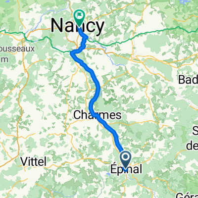
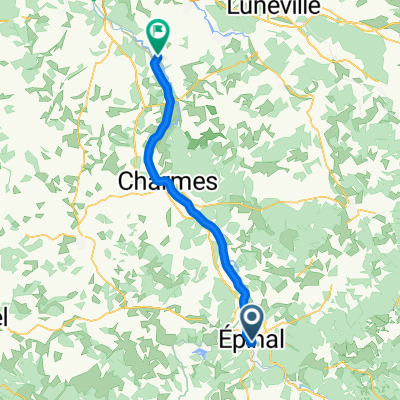
2009 Euro Tour -- Ride Day 29 — 28 July 2009 — 88000 Epinal — Circle
Eine Fahrradroute, die in Épinal, Alsace-Champagne-Ardenne-Lorraine, France beginnt.
Übersicht
Über diese Route
<div class="MsoNormal" style="color: #000000; font-family: Helvetica; font-size: medium;"><span style="font-family: Arial;"> <div class="MsoNormal">Nice ride in beautiful country without the weight of the panniers. Some climbing that felt very easy.</div> <div class="MsoNormal"> <div class="MsoNormal"> <div class="MsoNormal"> <div class="MsoNormal"></div> </div> </div> <div class="MsoNormal"><br /></div> </div> </span></div> <div class="MsoNormal" style="color: #000000; font-family: Helvetica; font-size: medium;">Background:<span style="font-family: Arial;"> <div class="MsoNormal" style="font-size: 16px;"><span style="font-family: Arial;"> </span></div> </span></div>
My wife and I have been doing self-supported tours in Western Europe (a majority in France) since 1993. This series of rides covers our 2009 4.5 month route through parts of France, Germany, Austria, Switzerland, and then back to France. Our beginning and ending point is near Chadurie (south of Angouleme) where our friends have a farm with Gites and Chambres d'Hotes.
We rode our Dawes touring bicycles purchased in 1993 heavily loaded with 700Cx32 tires. All of our riding was on paved roads, mostly with very little traffic. Pretty much the only unpaved sections were some bicycle paths in Germany and Austria. Sadly, that wasn't so great as Helen fell a number of times on the unpaved paths. Fortunately, though, no serious injury.
If any questions, feel free to email me at jeffkadet@netdiving.com
Jeff
- -:--
- Dauer
- 80,5 km
- Distanz
- 476 m
- Aufstieg
- 476 m
- Abstieg
- ---
- Ø-Tempo
- ---
- Ø-Tempo
Routenqualität
Wegtypen und Untergründe entlang der Route
Wegtypen
Vielbefahrene Straße
64,8 km
(80 %)
Ruhige Straße
8,5 km
(11 %)
Untergründe
Befestigt
33,4 km
(41 %)
Asphalt
33,4 km
(41 %)
Undefiniert
47,1 km
(59 %)
Weiter mit Bikemap
Diese Radroute verwenden, bearbeiten oder herunterladen
Du möchtest 2009 Euro Tour -- Ride Day 29 — 28 July 2009 — 88000 Epinal — Circle fahren oder sie für deine eigene Reise anpassen? Folgendes kannst du mit dieser Bikemap-Route machen:
Gratis Funktionen
- Speichere diese Route als Favorit oder in einer Sammlung
- Kopiere & plane deine eigene Version dieser Route
- Synchronisiere deine Route mit Garmin oder Wahoo
Premium-Funktionen
Kostenlose Testversion für 3 Tage oder einmalige Zahlung. Mehr über Bikemap Premium.
- Navigiere diese Route auf iOS & Android
- Exportiere eine GPX / KML-Datei dieser Route
- Erstelle deinen individuellen Ausdruck (Jetzt kostenlos ausprobieren)
- Lade diese Route für die Offline-Navigation herunter
Entdecke weitere Premium-Funktionen.
Bikemap Premium aktivierenVon unserer Community
Épinal: Andere beliebte Routen, die hier beginnen
- 03 Epinal - Ray-sur-Saone
- Distanz
- 134,9 km
- Aufstieg
- 148 m
- Abstieg
- 288 m
- Standort
- Épinal, Alsace-Champagne-Ardenne-Lorraine, Frankreich
- Boucle Raon- Mailleronfaing-Lamenil
- Distanz
- 70,1 km
- Aufstieg
- 513 m
- Abstieg
- 509 m
- Standort
- Épinal, Alsace-Champagne-Ardenne-Lorraine, Frankreich
- 2012 French Tour -- Ride Day 17 -- 25 August 2012 -- Épinal -- Circle
- Distanz
- 65,8 km
- Aufstieg
- 385 m
- Abstieg
- 385 m
- Standort
- Épinal, Alsace-Champagne-Ardenne-Lorraine, Frankreich
- CommercyTour2022_E3-3
- Distanz
- 126,4 km
- Aufstieg
- 1.301 m
- Abstieg
- 1.370 m
- Standort
- Épinal, Alsace-Champagne-Ardenne-Lorraine, Frankreich
- 2009 Euro Tour -- Ride Day 30 — 29 July 2009 — 88000 Epinal to 88400 Xonrupt-Longemer
- Distanz
- 48,8 km
- Aufstieg
- 519 m
- Abstieg
- 169 m
- Standort
- Épinal, Alsace-Champagne-Ardenne-Lorraine, Frankreich
- RnR Vosges Camp
- Distanz
- 204,5 km
- Aufstieg
- 3.098 m
- Abstieg
- 3.125 m
- Standort
- Épinal, Alsace-Champagne-Ardenne-Lorraine, Frankreich
- Épinal nach Saint-Maurice-sur-Moselle und Moselquelle
- Distanz
- 73,6 km
- Aufstieg
- 782 m
- Abstieg
- 554 m
- Standort
- Épinal, Alsace-Champagne-Ardenne-Lorraine, Frankreich
- 04-M. Epinal - Mulhouse (180,8 Km)
- Distanz
- 180,8 km
- Aufstieg
- 2.483 m
- Abstieg
- 2.588 m
- Standort
- Épinal, Alsace-Champagne-Ardenne-Lorraine, Frankreich
In der App öffnen