

Tonadico, Val Belluna, Valle del MIs
Eine Fahrradroute, die in Tonadico, Trentino-Alto Adige, Italy beginnt.
Übersicht
Über diese Route
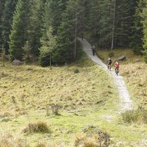
<span style="color: #eeeeee; font-family: sans-serif, helvetica; font-size: 13px; background-color: #000000;">During the tour the cyclist can watch some different landscapes: from the deep canyons of the Schener and the Mis valley to the nice villages of the Belluna valley and the houses in the middle of nowhere around Gosaldo.</span>
- -:--
- Dauer
- 100,8 km
- Distanz
- 1.558 m
- Aufstieg
- 1.528 m
- Abstieg
- ---
- Ø-Tempo
- ---
- Ø-Tempo
Weiter mit Bikemap
Diese Radroute verwenden, bearbeiten oder herunterladen
Du möchtest Tonadico, Val Belluna, Valle del MIs fahren oder sie für deine eigene Reise anpassen? Folgendes kannst du mit dieser Bikemap-Route machen:
Gratis Funktionen
- Speichere diese Route als Favorit oder in einer Sammlung
- Kopiere & plane deine eigene Version dieser Route
- Synchronisiere deine Route mit Garmin oder Wahoo
Premium-Funktionen
Kostenlose Testversion für 3 Tage oder einmalige Zahlung. Mehr über Bikemap Premium.
- Navigiere diese Route auf iOS & Android
- Exportiere eine GPX / KML-Datei dieser Route
- Erstelle deinen individuellen Ausdruck (Jetzt kostenlos ausprobieren)
- Lade diese Route für die Offline-Navigation herunter
Entdecke weitere Premium-Funktionen.
Bikemap Premium aktivierenVon unserer Community
Tonadico: Andere beliebte Routen, die hier beginnen
 GgGiro2019Etapa19Mis
- Distanz
- 22,6 km
- Aufstieg
- 901 m
- Abstieg
- 904 m
- Standort
- Tonadico, Trentino - Südtirol, Italien
 lago di calaita mtb
- Distanz
- 28,2 km
- Aufstieg
- 984 m
- Abstieg
- 984 m
- Standort
- Tonadico, Trentino - Südtirol, Italien
 GgGiro2019Etapa19
- Distanz
- 45,4 km
- Aufstieg
- 1.253 m
- Abstieg
- 1.256 m
- Standort
- Tonadico, Trentino - Südtirol, Italien
 Mytos by Panther 3
- Distanz
- 48,8 km
- Aufstieg
- 2.036 m
- Abstieg
- 2.038 m
- Standort
- Tonadico, Trentino - Südtirol, Italien
 rif. vederna
- Distanz
- 50,1 km
- Aufstieg
- 1.451 m
- Abstieg
- 1.450 m
- Standort
- Tonadico, Trentino - Südtirol, Italien
 királyetap
- Distanz
- 152,8 km
- Aufstieg
- 4.035 m
- Abstieg
- 4.035 m
- Standort
- Tonadico, Trentino - Südtirol, Italien
 Tonadico, Tognola, Forcella Val Sorda, Zortea, Tonadico
- Distanz
- 46,8 km
- Aufstieg
- 1.874 m
- Abstieg
- 1.874 m
- Standort
- Tonadico, Trentino - Südtirol, Italien
 Tonadico, Val Belluna, Valle del MIs
- Distanz
- 100,8 km
- Aufstieg
- 1.558 m
- Abstieg
- 1.528 m
- Standort
- Tonadico, Trentino - Südtirol, Italien
In der App öffnen