
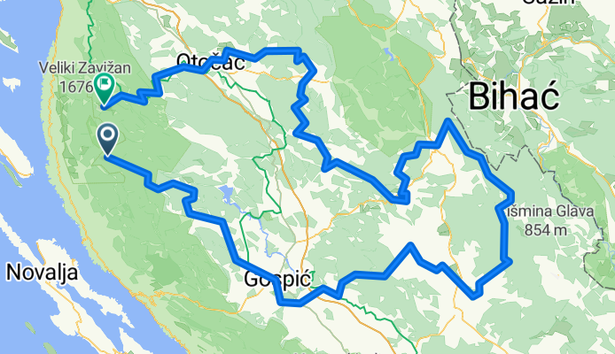
Paklenica National Park - Kamena galerija - Debeli kuk - Jama Golubinka - Ždrilski kuk 1165m - Ramino Korito - Kiza - Velebit - rest&view for2 - Krajačev...
Eine Fahrradroute, die in Popovača, Gespanschaft Lika-Senj, Kroatien beginnt.
Übersicht
Über diese Route
maphub-meta:{"marker-symbol": "camera", "marker-color": "#1b8893"} - maphub-meta:{"marker-symbol": "camera", "marker-color": "#1b8893"} - maphub-meta:{"marker-symbol": "camera", "marker-color": "#1b8893"} - maphub-meta:{"marker-symbol": "camera", "marker-color": "#1b8893"} - maphub-meta:{"marker-symbol": "camera", "marker-color": "#1b8893"} - maphub-meta:{"marker-symbol": "camera", "marker-color": "#1b8893"} - maphub-meta:{"marker-symbol": "camera", "marker-color": "#1b8893"} - maphub-meta:{"marker-symbol": "camera", "marker-color": "#1b8893"} - maphub-meta:{"marker-symbol": "camera", "marker-color": "#1b8893"} - maphub-meta:{"marker-symbol": "camera", "marker-color": "#1b8893"} - maphub-meta:{"marker-symbol": "camera", "marker-color": "#1b8893"} - maphub-meta:{"marker-symbol": "camera", "marker-color": "#1b8893"} - maphub-meta:{"marker-symbol": "camera", "marker-color": "#1b8893"} - maphub-meta:{"marker-symbol": "camera", "marker-color": "#1b8893"} - maphub-meta:{"marker-symbol": "camera", "marker-color": "#1b8893"} - maphub-meta:{"marker-symbol": "camera", "marker-color": "#1b8893"} - maphub-meta:{"marker-symbol": "camera", "marker-color": "#1b8893"} - maphub-meta:{"marker-symbol": "camera", "marker-color": "#1b8893"} - maphub-meta:{"marker-symbol": "camera", "marker-color": "#1b8893"} - maphub-meta:{"marker-symbol": "camera", "marker-color": "#1b8893"} - maphub-meta:{"marker-symbol": "camera", "marker-color": "#1b8893"} - maphub-meta:{"marker-symbol": "camera", "marker-color": "#1b8893"} - maphub-meta:{"marker-symbol": "camera", "marker-color": "#1b8893"} - maphub-meta:{"marker-symbol": "camera", "marker-color": "#1b8893"} - maphub-meta:{"marker-symbol": "camera", "marker-color": "#1b8893"} - maphub-meta:{"marker-symbol": "camera", "marker-color": "#1b8893"} - maphub-meta:{"marker-symbol": "camera", "marker-color": "#1b8893"} - maphub-meta:{"marker-symbol": "camera", "marker-color": "#1b8893"} - maphub-meta:{"marker-symbol": "camera", "marker-color": "#1b8893"} - maphub-meta:{"marker-symbol": "camera", "marker-color": "#1b8893"} - maphub-meta:{"marker-symbol": "camera", "marker-color": "#1b8893"} - maphub-meta:{"marker-symbol": "restaurant", "marker-color": "#cc1b15"} - maphub-meta:{"marker-symbol": "restaurant", "marker-color": "#cc1b15"} - maphub-meta:{"marker-symbol": "restaurant", "marker-color": "#cc1b15"} - maphub-meta:{"marker-symbol": "restaurant", "marker-color": "#cc1b15"} - maphub-meta:{"marker-symbol": "restaurant", "marker-color": "#cc1b15"} - maphub-meta:{"marker-symbol": "bar"} - maphub-meta:{"marker-symbol": "restaurant", "marker-color": "#cc1b15"} - maphub-meta:{"marker-symbol": "restaurant", "marker-color": "#cc1b15"} - maphub-meta:{"marker-symbol": "restaurant", "marker-color": "#cc1b15"} - maphub-meta:{"marker-symbol": "restaurant", "marker-color": "#cc1b15"} - maphub-meta:{"marker-symbol": "restaurant", "marker-color": "#cc1b15"} - maphub-meta:{"marker-symbol": "restaurant", "marker-color": "#cc1b15"} - maphub-meta:{"marker-symbol": "restaurant", "marker-color": "#cc1b15"} - maphub-meta:{"marker-symbol": "restaurant", "marker-color": "#cc1b15"} - maphub-meta:{"marker-symbol": "restaurant", "marker-color": "#cc1b15"} - maphub-meta:{"marker-symbol": "restaurant", "marker-color": "#cc1b15"} - maphub-meta:{"marker-symbol": "restaurant", "marker-color": "#cc1b15"} - maphub-meta:{"marker-symbol": "restaurant", "marker-color": "#cc1b15"} - maphub-meta:{"marker-symbol": "restaurant", "marker-color": "#cc1b15"} - maphub-meta:{"marker-symbol": "restaurant", "marker-color": "#cc1b15"} - maphub-meta:{"marker-symbol": "restaurant", "marker-color": "#cc1b15"} - maphub-meta:{"marker-symbol": "restaurant", "marker-color": "#cc1b15"} - maphub-meta:{"marker-symbol": "hotel", "marker-color": "#f1ae29"} - maphub-meta:{"marker-symbol": "hotel", "marker-color": "#f1ae29"} - maphub-meta:{"marker-symbol": "hotel", "marker-color": "#f1ae29"} - maphub-meta:{"marker-symbol": "hotel", "marker-color": "#f1ae29"} - maphub-meta:{"marker-symbol": "hotel", "marker-color": "#f1ae29"} - maphub-meta:{"marker-symbol": "hotel", "marker-color": "#f1ae29"} - maphub-meta:{"marker-symbol": "hotel", "marker-color": "#f1ae29"} - maphub-meta:{"marker-symbol": "hotel", "marker-color": "#f1ae29"} - maphub-meta:{"marker-symbol": "hotel", "marker-color": "#f1ae29"} - maphub-meta:{"marker-symbol": "hotel", "marker-color": "#f1ae29"} - maphub-meta:{"marker-symbol": "hotel", "marker-color": "#f1ae29"} - maphub-meta:{"marker-symbol": "hotel", "marker-color": "#f1ae29"} - maphub-meta:{"marker-symbol": "hotel", "marker-color": "#f1ae29"} - maphub-meta:{"marker-symbol": "church", "marker-color": "#444444"} - maphub-meta:{"marker-symbol": "church", "marker-color": "#444444"} - maphub-meta:{"marker-symbol": "church", "marker-color": "#444444"} - maphub-meta:{"marker-symbol": "church", "marker-color": "#444444"} - maphub-meta:{"marker-symbol": "church", "marker-color": "#444444"} - maphub-meta:{"marker-symbol": "church", "marker-color": "#444444"} - maphub-meta:{"marker-symbol": "church", "marker-color": "#444444"} - maphub-meta:{"marker-symbol": "church", "marker-color": "#444444"} - maphub-meta:{"marker-symbol": "church", "marker-color": "#444444"} - maphub-meta:{"marker-symbol": "church", "marker-color": "#444444"} - maphub-meta:{"marker-symbol": "church", "marker-color": "#444444"} - maphub-meta:{"marker-symbol": "church", "marker-color": "#444444"} - maphub-meta:{"marker-symbol": "church", "marker-color": "#444444"} - maphub-meta:{"marker-symbol": "church", "marker-color": "#444444"} - maphub-meta:{"marker-symbol": "church", "marker-color": "#444444"} - maphub-meta:{"marker-symbol": "church", "marker-color": "#444444"} - maphub-meta:{"marker-symbol": "church", "marker-color": "#444444"} - maphub-meta:{"marker-symbol": "shop", "marker-color": "#fb6033"} - maphub-meta:{"marker-symbol": "shop", "marker-color": "#fb6033"} - maphub-meta:{"marker-symbol": "shop", "marker-color": "#fb6033"} - maphub-meta:{"marker-symbol": "shop", "marker-color": "#fb6033"} - maphub-meta:{"marker-symbol": "shop", "marker-color": "#fb6033"}
- 26 h 33 min
- Dauer
- 284,2 km
- Distanz
- 8.194 m
- Aufstieg
- 8.112 m
- Abstieg
- 10,7 km/h
- Ø-Tempo
- 1.505 m
- Max. Höhe

Routenqualität
Wegtypen und Untergründe entlang der Route
Wegtypen
Forst- / Feldweg
122,2 km
(43 %)
Ruhige Straße
54 km
(19 %)
Untergründe
Befestigt
68,2 km
(24 %)
Unbefestigt
65,4 km
(23 %)
Asphalt
65,4 km
(23 %)
Schotter
31,3 km
(11 %)
Weiter mit Bikemap
Diese Radroute verwenden, bearbeiten oder herunterladen
Du möchtest Paklenica National Park - Kamena galerija - Debeli kuk - Jama Golubinka - Ždrilski kuk 1165m - Ramino Korito - Kiza - Velebit - rest&view for2 - Krajačev... fahren oder sie für deine eigene Reise anpassen? Folgendes kannst du mit dieser Bikemap-Route machen:
Gratis Funktionen
- Speichere diese Route als Favorit oder in einer Sammlung
- Kopiere & plane deine eigene Version dieser Route
- Teile sie in Etappen ein, um eine mehrtägige Tour zu erstellen
- Synchronisiere deine Route mit Garmin oder Wahoo
Premium-Funktionen
Kostenlose Testversion für 3 Tage oder einmalige Zahlung. Mehr über Bikemap Premium.
- Navigiere diese Route auf iOS & Android
- Exportiere eine GPX / KML-Datei dieser Route
- Erstelle deinen individuellen Ausdruck (Jetzt kostenlos ausprobieren)
- Lade diese Route für die Offline-Navigation herunter
Entdecke weitere Premium-Funktionen.
Bikemap Premium aktivierenVon unserer Community
Popovača: Andere beliebte Routen, die hier beginnen
 2014-02-B-KrusickoJezero-Prizna-71km
- Distanz
- 70,5 km
- Aufstieg
- 1.117 m
- Abstieg
- 1.637 m
- Standort
- Popovača, Gespanschaft Lika-Senj, Kroatien
 5199, Karlobag to Stinica, Senj
- Distanz
- 51,2 km
- Aufstieg
- 773 m
- Abstieg
- 1.794 m
- Standort
- Popovača, Gespanschaft Lika-Senj, Kroatien
 Štirovača-Alan-Jablanac-Senj
- Distanz
- 65,3 km
- Aufstieg
- 537 m
- Abstieg
- 1.624 m
- Standort
- Popovača, Gespanschaft Lika-Senj, Kroatien
 NAŠA RUTA 1
- Distanz
- 52,8 km
- Aufstieg
- 934 m
- Abstieg
- 934 m
- Standort
- Popovača, Gespanschaft Lika-Senj, Kroatien
 jezero - Gospić
- Distanz
- 19,8 km
- Aufstieg
- 202 m
- Abstieg
- 208 m
- Standort
- Popovača, Gespanschaft Lika-Senj, Kroatien
 Velebit_2019_3. nap_1. szakasz
- Distanz
- 44 km
- Aufstieg
- 380 m
- Abstieg
- 1.556 m
- Standort
- Popovača, Gespanschaft Lika-Senj, Kroatien
 Paklenica National Park - Kamena galerija - Debeli kuk - Jama Golubinka - Ždrilski kuk 1165m - Ramino Korito - Kiza - Velebit - rest&view for2 - Krajačev...
- Distanz
- 284,2 km
- Aufstieg
- 8.194 m
- Abstieg
- 8.112 m
- Standort
- Popovača, Gespanschaft Lika-Senj, Kroatien
 Velebit - dan 2
- Distanz
- 68,3 km
- Aufstieg
- 1.023 m
- Abstieg
- 1.405 m
- Standort
- Popovača, Gespanschaft Lika-Senj, Kroatien
In der App öffnen