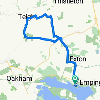
Rutland
- 24,4 km
- 119 m
- 119 m
- Empingham, England, Vereinigtes Königreich
Eine Fahrradroute, die in Empingham, England, Vereinigtes Königreich beginnt.
Übersicht
A gentle route from the north or south Carpark / bikehire, use the lakeside path to start and finish, if you are starting from the north car park use the path as its steadier to start for those not used to the bikes, nice flat roads to start with to get used to the bikes then a few slopes around Braunston / knossington then the pretty vilage of Lyndon. if you enter the south car park at Normanton and follow the riverside path, they have giant Zorbs on the dam wall which you can pay to go in. Good luck, will come if I can ! M.
Erstellt vor 13 Jahren
Routenqualität
Ruhige Straße
28,5 km
66 %
Straße
9,9 km
23 %
Befestigt
8,7 km
(20 %)
Asphalt
8,7 km
20 %
Undefiniert
34,6 km
80 %
Weiter mit Bikemap
Du möchtest Scotty Ash scenic route. fahren oder sie für deine eigene Reise anpassen? Folgendes kannst du mit dieser Bikemap-Route machen:
Kostenlose Testversion für 3 Tage oder einmalige Zahlung. Mehr über Bikemap Premium.
Entdecke weitere Premium-Funktionen.
Bikemap Premium aktivierenVon unserer Community
In der App öffnen