

MTS Solo Route
Eine Fahrradroute, die in Ban Chang, Rayong, Thailand beginnt.
Übersicht
Über diese Route
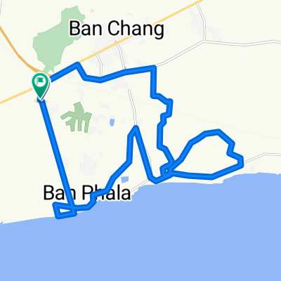
Beginnend am Taesaban 2/1 und nur westlich und nördlich des West-Eingangs des Eastern Star Resorts verläuft die Route nach Süden zum Strand und dann nach Osten parallel zur Bucht in Richtung Maptaput, wobei Landstraßen mit geringem Verkehrsaufkommen genutzt werden. Die Route biegt nach Norden in Richtung Sukhumvit Rd ab, bevor sie Maptaput erreicht, und kehrt dann nach Westen zum Ausgangspunkt zurück. Die Straßen sind überwiegend flach und zu 99 % asphaltiert. Geeignet für sowohl Mountainbikes als auch Rennräder. Die Route führt durch einige Eukalyptus- und Mangoplantagen und überwiegend durch die Landschaft.
- -:--
- Dauer
- 32,5 km
- Distanz
- 100 m
- Aufstieg
- 97 m
- Abstieg
- ---
- Ø-Tempo
- ---
- Max. Höhe

Highlights der Route
POIs entlang der Route
Interessanter Ort nach 0 km
Beginning on Taesaban 2/1 just Wast and North of the Eastern Star Resort West entrance, the route heads South to the beach then East paralleling the Gulf toward MapTaPut utilizing country sois with low volumne traffic. The route turns North headed toward Sukhumvit Rd before reaching Maptaput then heads back to the West toward the starting point. The roads are primarily flat and 99% paved. Suitable for both mountain and road bikes. The route travels through some eucalyptus and mango plantations and mostly country side.
Weiter mit Bikemap
Diese Radroute verwenden, bearbeiten oder herunterladen
Du möchtest MTS Solo Route fahren oder sie für deine eigene Reise anpassen? Folgendes kannst du mit dieser Bikemap-Route machen:
Gratis Funktionen
- Speichere diese Route als Favorit oder in einer Sammlung
- Kopiere & plane deine eigene Version dieser Route
- Synchronisiere deine Route mit Garmin oder Wahoo
Premium-Funktionen
Kostenlose Testversion für 3 Tage oder einmalige Zahlung. Mehr über Bikemap Premium.
- Navigiere diese Route auf iOS & Android
- Exportiere eine GPX / KML-Datei dieser Route
- Erstelle deinen individuellen Ausdruck (Jetzt kostenlos ausprobieren)
- Lade diese Route für die Offline-Navigation herunter
Entdecke weitere Premium-Funktionen.
Bikemap Premium aktivierenVon unserer Community
Ban Chang: Andere beliebte Routen, die hier beginnen
 MTS Solo Ride (2)
- Distanz
- 43,4 km
- Aufstieg
- 145 m
- Abstieg
- 145 m
- Standort
- Ban Chang, Rayong, Thailand
 วัดเส้นทางใหม่
- Distanz
- 42,5 km
- Aufstieg
- 185 m
- Abstieg
- 225 m
- Standort
- Ban Chang, Rayong, Thailand
 MTS's Samersan Fish Market and Fishing Village Route
- Distanz
- 40,8 km
- Aufstieg
- 150 m
- Abstieg
- 158 m
- Standort
- Ban Chang, Rayong, Thailand
 Michael's Ban Chang, Klaeng, Wang Chon Route
- Distanz
- 240,4 km
- Aufstieg
- 376 m
- Abstieg
- 388 m
- Standort
- Ban Chang, Rayong, Thailand
 Hokien Noodles/Brookside Ride
- Distanz
- 140,7 km
- Aufstieg
- 247 m
- Abstieg
- 248 m
- Standort
- Ban Chang, Rayong, Thailand
 MTS Solo Route
- Distanz
- 32,5 km
- Aufstieg
- 100 m
- Abstieg
- 97 m
- Standort
- Ban Chang, Rayong, Thailand
 4 June 2014
- Distanz
- 92 km
- Aufstieg
- 339 m
- Abstieg
- 341 m
- Standort
- Ban Chang, Rayong, Thailand
 Ban Chang-Plutaluang-Silver Lake-332-Ban Chang
- Distanz
- 54,9 km
- Aufstieg
- 256 m
- Abstieg
- 253 m
- Standort
- Ban Chang, Rayong, Thailand
In der App öffnen