

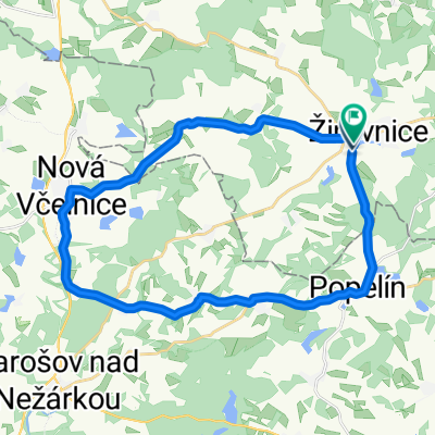
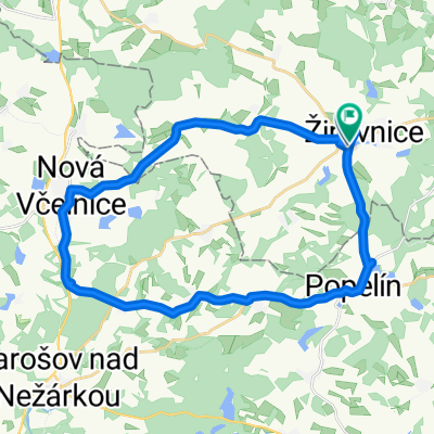
Naučná cykloturistická stezka „Pamětihodnosti žirovnicka“ (Žirovnice – Popelín – Vlčetín – Štítné – Stranná – Metánov – Žirovnice)
Eine Fahrradroute, die in Žirovnice, Region Hochland, Tschechien beginnt.
Übersicht
Über diese Route
<table class="MsoNormalTable" style="width: 99.28%; mso-cellspacing: 0cm; background: #FFFFCC; mso-padding-alt: 0cm 0cm 0cm 0cm;" border="1" cellspacing="0" cellpadding="0" width="99%"> <tbody> <tr style="mso-yfti-irow: 0; mso-yfti-firstrow: yes;"> <td style="width: 30.22%; background: #DFDFDF; padding: 0cm 0cm 0cm 0cm;" width="30%">
<span style="font-size: 16pt; font-family: "Arial","sans-serif";">začátek</span> </td> <td style="width: 69.78%; background: #FFFFD5; padding: 0cm 0cm 0cm 0cm;" width="69%">
<span style="font-size: 16pt; font-family: "Arial","sans-serif";">Zámek Žirovnice</span> </td> </tr> <tr style="mso-yfti-irow: 1;"> <td style="width: 30.22%; background: #DFDFDF; padding: 0cm 0cm 0cm 0cm;" width="30%">
<span style="font-size: 16pt; font-family: "Arial","sans-serif";">konec</span> </td> <td style="width: 69.78%; background: #FFFFD5; padding: 0cm 0cm 0cm 0cm;" width="69%">
<span style="font-size: 16pt; font-family: "Arial","sans-serif";">totožný se začátkem - okruh</span> </td> </tr> <tr style="mso-yfti-irow: 2;"> <td style="width: 30.22%; background: #DFDFDF; padding: 0cm 0cm 0cm 0cm;" width="30%">
<span style="font-size: 16pt; font-family: "Arial","sans-serif";">délka</span> </td> <td style="width: 69.78%; background: #FFFFD5; padding: 0cm 0cm 0cm 0cm;" width="69%">
<span style="font-size: 16pt; font-family: "Arial","sans-serif";">cca 24,0 km</span> </td> </tr> <tr style="mso-yfti-irow: 3;"> <td style="width: 30.22%; background: #DFDFDF; padding: 0cm 0cm 0cm 0cm;" width="30%">
<span style="font-size: 16pt; font-family: "Arial","sans-serif";">z toho: prašná cesta</span> </td> <td style="width: 69.78%; background: #FFFFD5; padding: 0cm 0cm 0cm 0cm;" width="69%">
<span style="font-size: 16pt; font-family: "Arial","sans-serif";">11,0</span> </td> </tr> <tr style="mso-yfti-irow: 4;"> <td style="width: 30.22%; background: #DFDFDF; padding: 0cm 0cm 0cm 0cm;" width="30%">
<span style="font-size: 16pt; font-family: "Arial","sans-serif";">z toho: asfaltová cesta</span> </td> <td style="width: 69.78%; background: #FFFFD5; padding: 0cm 0cm 0cm 0cm;" width="69%">
<span style="font-size: 16pt; font-family: "Arial","sans-serif";">13,0</span> </td> </tr> <tr style="mso-yfti-irow: 5;"> <td style="width: 30.22%; background: #DFDFDF; padding: 0cm 0cm 0cm 0cm;" width="30%">
<span style="font-size: 16pt; font-family: "Arial","sans-serif";">počet zastávek</span> </td> <td style="width: 69.78%; background: #FFFFD5; padding: 0cm 0cm 0cm 0cm;" width="69%">
<span style="font-size: 16pt; font-family: "Arial","sans-serif";">6</span> </td> </tr> <tr style="mso-yfti-irow: 6;"> <td style="width: 30.22%; background: #DFDFDF; padding: 0cm 0cm 0cm 0cm;" width="30%">
<span style="font-size: 16pt; font-family: "Arial","sans-serif";">zaměření</span> </td> <td style="width: 69.78%; background: #FFFFD5; padding: 0cm 0cm 0cm 0cm;" width="69%">
<span style="font-size: 16pt; font-family: "Arial","sans-serif";">historie</span> </td> </tr> <tr style="mso-yfti-irow: 7;"> <td style="width: 30.22%; background: #DFDFDF; padding: 0cm 0cm 0cm 0cm;" width="30%">
<span style="font-size: 16pt; font-family: "Arial","sans-serif";">typ stezky</span> </td> <td style="width: 69.78%; background: #FFFFD5; padding: 0cm 0cm 0cm 0cm;" width="69%">
<span style="font-size: 16pt; font-family: "Arial","sans-serif";">cyklistická</span> </td> </tr> <tr style="mso-yfti-irow: 8;"> <td style="width: 30.22%; background: #DFDFDF; padding: 0cm 0cm 0cm 0cm;" width="30%">
<span style="font-size: 16pt; font-family: "Arial","sans-serif";">náročnost</span> </td> <td style="width: 69.78%; background: #FFFFD5; padding: 0cm 0cm 0cm 0cm;" width="69%">
<span style="font-size: 16pt; font-family: "Arial","sans-serif";">lehká až střední</span> </td> </tr> <tr style="mso-yfti-irow: 9; mso-yfti-lastrow: yes;"> <td style="width: 30.22%; background: #DFDFDF; padding: 0cm 0cm 0cm 0cm;" width="30%">
<span style="font-size: 16pt; font-family: "Arial","sans-serif";">značení</span> </td> <td style="width: 69.78%; background: #FFFFD5; padding: 0cm 0cm 0cm 0cm;" width="69%">
<span style="font-size: 16pt; font-family: "Arial","sans-serif";">značky a orientační tabule</span> </td> </tr> </tbody> </table>
- -:--
- Dauer
- 23,7 km
- Distanz
- 252 m
- Aufstieg
- 252 m
- Abstieg
- ---
- Ø-Tempo
- ---
- Max. Höhe
Routenqualität
Wegtypen und Untergründe entlang der Route
Wegtypen
Straße
14,1 km
(60 %)
Forst- / Feldweg
6,6 km
(28 %)
Untergründe
Befestigt
2,6 km
(11 %)
Unbefestigt
6,3 km
(27 %)
Schotter
4,5 km
(19 %)
Asphalt
2,3 km
(10 %)
Weiter mit Bikemap
Diese Radroute verwenden, bearbeiten oder herunterladen
Du möchtest Naučná cykloturistická stezka „Pamětihodnosti žirovnicka“ (Žirovnice – Popelín – Vlčetín – Štítné – Stranná – Metánov – Žirovnice) fahren oder sie für deine eigene Reise anpassen? Folgendes kannst du mit dieser Bikemap-Route machen:
Gratis Funktionen
- Speichere diese Route als Favorit oder in einer Sammlung
- Kopiere & plane deine eigene Version dieser Route
- Synchronisiere deine Route mit Garmin oder Wahoo
Premium-Funktionen
Kostenlose Testversion für 3 Tage oder einmalige Zahlung. Mehr über Bikemap Premium.
- Navigiere diese Route auf iOS & Android
- Exportiere eine GPX / KML-Datei dieser Route
- Erstelle deinen individuellen Ausdruck (Jetzt kostenlos ausprobieren)
- Lade diese Route für die Offline-Navigation herunter
Entdecke weitere Premium-Funktionen.
Bikemap Premium aktivierenVon unserer Community
Žirovnice: Andere beliebte Routen, die hier beginnen
 ČESKÝ POHÁR MUŽI
- Distanz
- 16,2 km
- Aufstieg
- 192 m
- Abstieg
- 192 m
- Standort
- Žirovnice, Region Hochland, Tschechien
 Žirovnice tour
- Distanz
- 14,6 km
- Aufstieg
- 149 m
- Abstieg
- 150 m
- Standort
- Žirovnice, Region Hochland, Tschechien
 Babory do Babory
- Distanz
- 27 km
- Aufstieg
- 338 m
- Abstieg
- 382 m
- Standort
- Žirovnice, Region Hochland, Tschechien
 2010-07-18 ATC Žirovnice-Pelhřimov-Koberovice-Kožlí-Podhradí-Bohdaneč 76,7 km
- Distanz
- 76,7 km
- Aufstieg
- 617 m
- Abstieg
- 733 m
- Standort
- Žirovnice, Region Hochland, Tschechien
 Žirovnice - JH - 2
- Distanz
- 21,3 km
- Aufstieg
- 167 m
- Abstieg
- 248 m
- Standort
- Žirovnice, Region Hochland, Tschechien
 Příprava na bystřici
- Distanz
- 29,1 km
- Aufstieg
- 381 m
- Abstieg
- 424 m
- Standort
- Žirovnice, Region Hochland, Tschechien
 ČP - mládeže Žirovnice - O pohár hotelu Artaban
- Distanz
- 16,8 km
- Aufstieg
- 181 m
- Abstieg
- 182 m
- Standort
- Žirovnice, Region Hochland, Tschechien
 RBB Tour II. Etapa
- Distanz
- 16,4 km
- Aufstieg
- 185 m
- Abstieg
- 186 m
- Standort
- Žirovnice, Region Hochland, Tschechien
In der App öffnen