

Glen Cove Loop
Eine Fahrradroute, die in Crockett, Kalifornien, Vereinigte Staaten beginnt.
Übersicht
Über diese Route
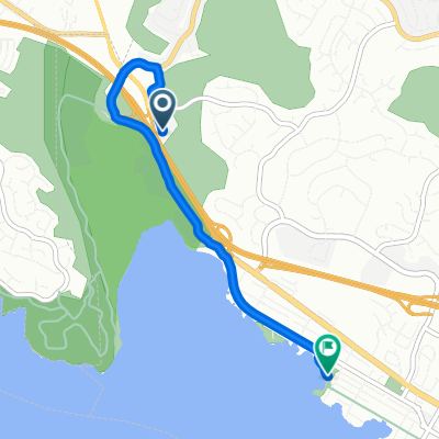
Experience this relatively short loop around the southwestern part of Vallejo and east end of Benicia.
The trip stages at the new and contravercial Glen Cove Waterfront Park, where you'll ride one of the newest stretches of the SF Bay Trail, a loosely paved/tightly packed gravel path along the western end of the park, turning south toward Benicia State Recreational Park.
Near the end of the paved road, you'll merge onto a dirt path leading into the State Park, where you'll climb a few hills in a northeast direction, eventually riding the flat, paved Dillon Point Road along Southampton Bay.
Once you reach the main entrance to the park, you'll cross the new cycle overpass over I-780 and begin to return to Glen Cove via. Columbus Parkway and Benicia Road.
Turning left onto Glen Cove Parkway, you continue your steady climb along the bike path, before going completely downhill all the way back to where you started.
- -:--
- Dauer
- 8,6 km
- Distanz
- 144 m
- Aufstieg
- 142 m
- Abstieg
- ---
- Ø-Tempo
- ---
- Max. Höhe
Routenqualität
Wegtypen und Untergründe entlang der Route
Wegtypen
Vielbefahrene Straße
3,7 km
(43 %)
Radweg
1,8 km
(21 %)
Untergründe
Befestigt
2,1 km
(24 %)
Unbefestigt
0,9 km
(10 %)
Asphalt
1,5 km
(17 %)
Beton
0,5 km
(6 %)
Weiter mit Bikemap
Diese Radroute verwenden, bearbeiten oder herunterladen
Du möchtest Glen Cove Loop fahren oder sie für deine eigene Reise anpassen? Folgendes kannst du mit dieser Bikemap-Route machen:
Gratis Funktionen
- Speichere diese Route als Favorit oder in einer Sammlung
- Kopiere & plane deine eigene Version dieser Route
- Synchronisiere deine Route mit Garmin oder Wahoo
Premium-Funktionen
Kostenlose Testversion für 3 Tage oder einmalige Zahlung. Mehr über Bikemap Premium.
- Navigiere diese Route auf iOS & Android
- Exportiere eine GPX / KML-Datei dieser Route
- Erstelle deinen individuellen Ausdruck (Jetzt kostenlos ausprobieren)
- Lade diese Route für die Offline-Navigation herunter
Entdecke weitere Premium-Funktionen.
Bikemap Premium aktivierenVon unserer Community
Crockett: Andere beliebte Routen, die hier beginnen
 Route to 1700 Nevin Ave, Richmond
- Distanz
- 23,7 km
- Aufstieg
- 220 m
- Abstieg
- 230 m
- Standort
- Crockett, Kalifornien, Vereinigte Staaten
 Martinez Loop
- Distanz
- 38 km
- Aufstieg
- 334 m
- Abstieg
- 345 m
- Standort
- Crockett, Kalifornien, Vereinigte Staaten
 Route from I-780 W, Benicia
- Distanz
- 4 km
- Aufstieg
- 17 m
- Abstieg
- 26 m
- Standort
- Crockett, Kalifornien, Vereinigte Staaten
 Bailey St, Vallejo to 1212 Wanda St, Crockett
- Distanz
- 9,4 km
- Aufstieg
- 0 m
- Abstieg
- 7 m
- Standort
- Crockett, Kalifornien, Vereinigte Staaten
 Glen Cove Loop
- Distanz
- 8,6 km
- Aufstieg
- 144 m
- Abstieg
- 142 m
- Standort
- Crockett, Kalifornien, Vereinigte Staaten
 Greenmont Drive 1101, Vallejo to Greenmont Drive 1031, Vallejo
- Distanz
- 77,4 km
- Aufstieg
- 1.032 m
- Abstieg
- 1.032 m
- Standort
- Crockett, Kalifornien, Vereinigte Staaten
 McEwen Rd
- Distanz
- 0,9 km
- Aufstieg
- 106 m
- Abstieg
- 0 m
- Standort
- Crockett, Kalifornien, Vereinigte Staaten
 Blistering ride in Benicia
- Distanz
- 55,3 km
- Aufstieg
- 5 m
- Abstieg
- 40 m
- Standort
- Crockett, Kalifornien, Vereinigte Staaten
In der App öffnen