
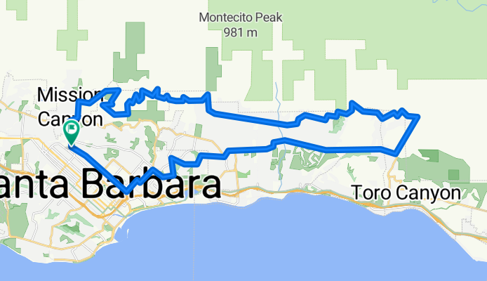

Santa Barbara Thirty
- 48,5 km
- 423 m
- 423 m
- Mission Canyon, Kalifornien, Vereinigte Staaten
Eine Fahrradroute, die in Mission Canyon, Kalifornien, Vereinigte Staaten beginnt.
Übersicht
Diese Route nutzt alle wichtigen asphaltierten Straßen in der Santa Barbara Gegend, die den Vorgebirgsausläufern folgen. Der Vorgebirgsabschnitt der Schleife hat wenig Autoverkehr, bietet fantastische Aussichten und eine gute Vielfalt an Steigungen.
Im Uhrzeigersinn wird empfohlen, hauptsächlich wegen der herausfordernden Steigung der Toro Canyon Rd und dem lächerlich steilen, wenn auch kurzen, östlichen Beginn der Viola Ln. Plane, hart hinaufzufahren auf der Las Canoas Rd bis zum Skofield Park, dann auf der Park Lane und Bella Vista und schließlich auf ein paar steilen Abschnitten der Viola Ln. Der Rest ist moderat.
Ein paar Warnungen: (1) Trotz der Darstellung bei Google Maps endet der East Mountain Dr kurz nach der San Ysidro Ln, da er durch das private San Ysidro Ranch Resort blockiert wird. Es ist jedoch möglich, durch das Resort zu radeln - einfach der gepflasterten Zufahrt folgen. (2) Die privat betriebene Viola Lane ist an beiden Enden nicht gut ausgeschildert. Achte auf eine Gruppe schwarzer Briefkästen kurz nachdem die kurvenreiche Bella Vista Drive auf die schnurgerade Ladera Lane trifft.
Erstellt vor 12 Jahren
Weiter mit Bikemap
Du möchtest Santa Barbara / Montecito foothills loop CLONED FROM ROUTE 552049 fahren oder sie für deine eigene Reise anpassen? Folgendes kannst du mit dieser Bikemap-Route machen:
Kostenlose Testversion für 3 Tage oder einmalige Zahlung. Mehr über Bikemap Premium.
Entdecke weitere Premium-Funktionen.
Bikemap Premium aktivierenVon unserer Community
In der App öffnen


