

Great Falls and back
Eine Fahrradroute, die in Cabin John, Maryland, United States of America beginnt.
Übersicht
Über diese Route
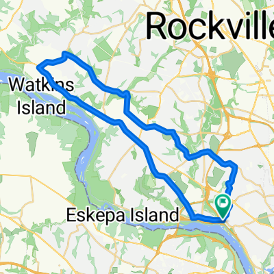
Start at parking lot off MacArthur Blvd on east end of one way bridge. Follow trail downhill and under freeways. Take footbridge across C&O canal and turn right on tow path.
Follow tow path along the canal, past several footbridges and the "Widewater" lake. Canal locks on your right, the Potomac is on your left. Look out for herons and turtles in the canal.
Cross over the canal at the former Great Falls Tavern. Food available at concession stand.
Go through parking lot and follow MacArthur Blvd up the hill (steep).
At the top, follow MacArthur Blvd to the right (steep downhill).
Old Angler's Inn at the foot of the hill on your left (fancy inside, casual outside).
Follow MacArthur Blvd (bike path) to return to parking lot.
- -:--
- Dauer
- 21,5 km
- Distanz
- 167 m
- Aufstieg
- 147 m
- Abstieg
- ---
- Ø-Tempo
- 125 m
- Ø-Tempo
Routenqualität
Wegtypen und Untergründe entlang der Route
Wegtypen
Radweg
14,2 km
(66 %)
Vielbefahrene Straße
4,8 km
(22 %)
Untergründe
Befestigt
5,8 km
(27 %)
Unbefestigt
12,6 km
(58 %)
Natürlicher Untergrund
11,7 km
(54 %)
Asphalt
3,9 km
(18 %)
Weiter mit Bikemap
Diese Radroute verwenden, bearbeiten oder herunterladen
Du möchtest Great Falls and back fahren oder sie für deine eigene Reise anpassen? Folgendes kannst du mit dieser Bikemap-Route machen:
Gratis Funktionen
- Speichere diese Route als Favorit oder in einer Sammlung
- Kopiere & plane deine eigene Version dieser Route
- Synchronisiere deine Route mit Garmin oder Wahoo
Premium-Funktionen
Kostenlose Testversion für 3 Tage oder einmalige Zahlung. Mehr über Bikemap Premium.
- Navigiere diese Route auf iOS & Android
- Exportiere eine GPX / KML-Datei dieser Route
- Erstelle deinen individuellen Ausdruck (Jetzt kostenlos ausprobieren)
- Lade diese Route für die Offline-Navigation herunter
Entdecke weitere Premium-Funktionen.
Bikemap Premium aktivierenVon unserer Community
Cabin John: Andere beliebte Routen, die hier beginnen
 Bethesda to DC trails
- Distanz
- 21,2 km
- Aufstieg
- 101 m
- Abstieg
- 105 m
- Standort
- Cabin John, Maryland, USA
 meetup group apparent ride 7-7-19
- Distanz
- 35 km
- Aufstieg
- 99 m
- Abstieg
- 102 m
- Standort
- Cabin John, Maryland, USA
 37 Mile Loop
- Distanz
- 59,9 km
- Aufstieg
- 619 m
- Abstieg
- 619 m
- Standort
- Cabin John, Maryland, USA
 Glen Echo to Travilah
- Distanz
- 37,9 km
- Aufstieg
- 356 m
- Abstieg
- 349 m
- Standort
- Cabin John, Maryland, USA
 Maryland
- Distanz
- 213 km
- Aufstieg
- 1.244 m
- Abstieg
- 1.093 m
- Standort
- Cabin John, Maryland, USA
 Glen Echo to Persimmon 22 mi
- Distanz
- 22 km
- Aufstieg
- 163 m
- Abstieg
- 163 m
- Standort
- Cabin John, Maryland, USA
 EYP/DC Fundraiser Loop
- Distanz
- 69,2 km
- Aufstieg
- 776 m
- Abstieg
- 776 m
- Standort
- Cabin John, Maryland, USA
 Cabin John to White's Ferry
- Distanz
- 92,8 km
- Aufstieg
- 710 m
- Abstieg
- 680 m
- Standort
- Cabin John, Maryland, USA
In der App öffnen