

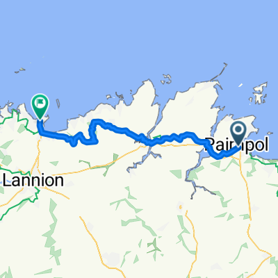
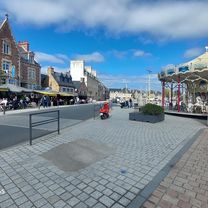
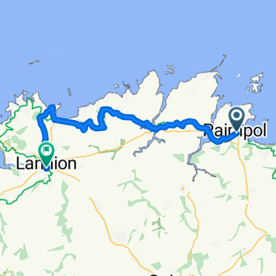
Paimpol - Ile Grande 11.06.2013 / 4th Stage
Eine Fahrradroute, die in Paimpol, Bretagne, Frankreich beginnt.
Übersicht
Über diese Route
Cesta zpevněná po silnici, občas polní a tomu podobné cesty.
Zajímavosti na trase :
- 18.km : zbytek starého mostu - město Tréguiers
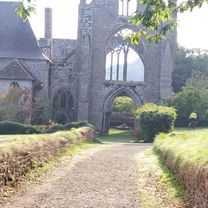
- 20.km : cathedrale Saint-Tugdual - město Tréguiers
- 34.km : výběžek Le Gouffre (severně od Plougrescant)
- 44.km : přejezd přes moře není po mostu ale po pláži během odlivu (možno do cca 19-ti hodin)
- 65.km : vyhlídka + maják De Men Ruz
- 71.km : ostrov Ile Renote (příjemný výlet po mini ostrůvku, svlažení nohou nebo i celého těla, nějaký ten Dolmen)
Údaje z cyklocomputeru:
délka 84,08 km / nastoupáno 1161 m / čas 4:51:23 hod
CampingMunicipal du Dourlin (Ile Grande) :
čistý kemp; teplá voda; stojan s elektrikou za poplatek; sprchy O.K.
V těsné blízkosti kempu byla rozjetá stavba a dle správce by nás měly v 7 hod ráno budit stroje - francouzi asi zaspali a tak bylo ráno ticho. Kemp se nachází hned na pobřeží a tak jihozápadní vítr jsme měli hned z první ruky. Pokud by tento kemp nevyhovoval, byl ještě jeden otevřený u odbočky na Ile Grande v městečku Penvern a na jeden byl ukazatel přímo na ostrově Ile Grande na jeho západní části.
- -:--
- Dauer
- 82,9 km
- Distanz
- 469 m
- Aufstieg
- 478 m
- Abstieg
- ---
- Ø-Tempo
- ---
- Max. Höhe

Routenqualität
Wegtypen und Untergründe entlang der Route
Wegtypen
Ruhige Straße
39,8 km
(48 %)
Straße
17,4 km
(21 %)
Untergründe
Befestigt
48,9 km
(59 %)
Unbefestigt
4,1 km
(5 %)
Asphalt
48,9 km
(59 %)
Schotter
2,5 km
(3 %)
Weiter mit Bikemap
Diese Radroute verwenden, bearbeiten oder herunterladen
Du möchtest Paimpol - Ile Grande 11.06.2013 / 4th Stage fahren oder sie für deine eigene Reise anpassen? Folgendes kannst du mit dieser Bikemap-Route machen:
Gratis Funktionen
- Speichere diese Route als Favorit oder in einer Sammlung
- Kopiere & plane deine eigene Version dieser Route
- Teile sie in Etappen ein, um eine mehrtägige Tour zu erstellen
- Synchronisiere deine Route mit Garmin oder Wahoo
Premium-Funktionen
Kostenlose Testversion für 3 Tage oder einmalige Zahlung. Mehr über Bikemap Premium.
- Navigiere diese Route auf iOS & Android
- Exportiere eine GPX / KML-Datei dieser Route
- Erstelle deinen individuellen Ausdruck (Jetzt kostenlos ausprobieren)
- Lade diese Route für die Offline-Navigation herunter
Entdecke weitere Premium-Funktionen.
Bikemap Premium aktivierenVon unserer Community
Paimpol: Andere beliebte Routen, die hier beginnen
 Rue de Cruckin nach Rue de Cruckin
- Distanz
- 60,6 km
- Aufstieg
- 702 m
- Abstieg
- 757 m
- Standort
- Paimpol, Bretagne, Frankreich
 Paimpol - Ile Grande 11.06.2013 / 4th Stage
- Distanz
- 83 km
- Aufstieg
- 464 m
- Abstieg
- 473 m
- Standort
- Paimpol, Bretagne, Frankreich
 Ride des Mousettes - Day 3
- Distanz
- 149,8 km
- Aufstieg
- 597 m
- Abstieg
- 574 m
- Standort
- Paimpol, Bretagne, Frankreich
 3-й день
- Distanz
- 50,1 km
- Aufstieg
- 358 m
- Abstieg
- 358 m
- Standort
- Paimpol, Bretagne, Frankreich
 Paimpol - Perros-Guirec
- Distanz
- 44,5 km
- Aufstieg
- 384 m
- Abstieg
- 341 m
- Standort
- Paimpol, Bretagne, Frankreich
 Paimpol - Trèguier
- Distanz
- 18,1 km
- Aufstieg
- 151 m
- Abstieg
- 132 m
- Standort
- Paimpol, Bretagne, Frankreich
 Quai Armand Dayot nach Rue de Cruckin
- Distanz
- 16,7 km
- Aufstieg
- 131 m
- Abstieg
- 180 m
- Standort
- Paimpol, Bretagne, Frankreich
 Paimpol - Perros-Guirec
- Distanz
- 57,5 km
- Aufstieg
- 503 m
- Abstieg
- 501 m
- Standort
- Paimpol, Bretagne, Frankreich
In der App öffnen