
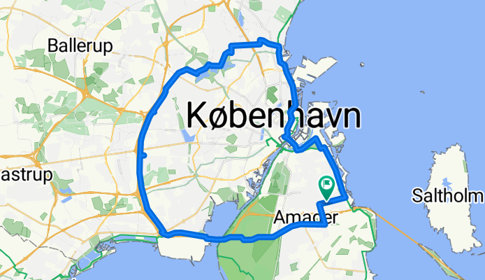
Vestvolden rundt
Eine Fahrradroute, die in Tårnby, Hauptstadtregion, Dänemark beginnt.
Übersicht
Über diese Route
Start und Ziel befinden sich im Airport Dan Hotel.
Überwiegend asphaltiert, aber nicht zu 100%. Enthält einen großen Teil des sehr angenehmen Radwegs entlang der alten westlichen Befestigungen.
Der Radweg biegt rechts von der Vejlands Alee @ Center Blvd ab; nicht gut markiert --- Sie MUSS den Busfahrstreifen nicht benutzen; der eigentliche Radweg liegt nur nördlich davon; durch Bäume getrennt; ganz schön.
Osten zu vermeiden: Der Vestvolden-Weg führt den Radfahrer über die Gammel Koge Landevej, dann nach rechts und nach dem Überqueren des Grabens nach links.
Wenn das GPS zu weit 'außen' eingestellt ist, kann man auf einen scheinbaren Stillstand an einem Bahngleis stoßen -- die Überquerung ist ein Unterführungsbereich, nur ein paar Hundert Meter nach Osten.
Die 156 Roskildervej wird über eine Rad-/Fußgängerbrücke überquert; die Abzweigung des Weges kann leicht verpasst werden.
Die Überquerung der E47 Jyllingevej erfolgt über eine Radfahrerbrücke mit Treppen und einem einzelnen Radkanal; zu steil für einige Lastenräder (z. B. Winther Kangaroo), um hindurchzukommen; schlecht für viele Dreiräder und Velomobile; eine störungsfreie (aber ungeschützte, unkontrollierte und wahrscheinlich illegale) Überquerung kann weniger als 100 m östlich gemacht werden.
Der Weg endet an der Bahnlinie kurz vor der 211; der Rückweg ist kurz, wenn man den Abzweig zur Fahrradüberführung (gg) verpasst. Das Schild lautet '> Utterslev Mose'.
Insgesamt waren es etwas mehr als 36 Meilen, als wir es gemacht haben (einige Umwege).
(cloned from route 338766)
- -:--
- Dauer
- 51,3 km
- Distanz
- 50 m
- Aufstieg
- 50 m
- Abstieg
- ---
- Ø-Tempo
- ---
- Max. Höhe

Routenqualität
Wegtypen und Untergründe entlang der Route
Wegtypen
Radweg
20,5 km
(40 %)
Straße
16,9 km
(33 %)
Untergründe
Befestigt
49,7 km
(97 %)
Unbefestigt
1 km
(2 %)
Asphalt
49,7 km
(97 %)
Schotter
1 km
(2 %)
Undefiniert
0,5 km
(1 %)
Weiter mit Bikemap
Diese Radroute verwenden, bearbeiten oder herunterladen
Du möchtest Vestvolden rundt fahren oder sie für deine eigene Reise anpassen? Folgendes kannst du mit dieser Bikemap-Route machen:
Gratis Funktionen
- Speichere diese Route als Favorit oder in einer Sammlung
- Kopiere & plane deine eigene Version dieser Route
- Synchronisiere deine Route mit Garmin oder Wahoo
Premium-Funktionen
Kostenlose Testversion für 3 Tage oder einmalige Zahlung. Mehr über Bikemap Premium.
- Navigiere diese Route auf iOS & Android
- Exportiere eine GPX / KML-Datei dieser Route
- Erstelle deinen individuellen Ausdruck (Jetzt kostenlos ausprobieren)
- Lade diese Route für die Offline-Navigation herunter
Entdecke weitere Premium-Funktionen.
Bikemap Premium aktivierenVon unserer Community
Tårnby: Andere beliebte Routen, die hier beginnen
 Rundt om havnen
- Distanz
- 23,5 km
- Aufstieg
- 13 m
- Abstieg
- 13 m
- Standort
- Tårnby, Hauptstadtregion, Dänemark
 Round Amager 3
- Distanz
- 39,8 km
- Aufstieg
- 16 m
- Abstieg
- 17 m
- Standort
- Tårnby, Hauptstadtregion, Dänemark
 Vestvolden rundt
- Distanz
- 51,3 km
- Aufstieg
- 50 m
- Abstieg
- 50 m
- Standort
- Tårnby, Hauptstadtregion, Dänemark
 Richard Mortensens Vej 73, København S to Richard Mortensens Vej 80, København S
- Distanz
- 29,4 km
- Aufstieg
- 73 m
- Abstieg
- 71 m
- Standort
- Tårnby, Hauptstadtregion, Dänemark
 Hvidovre turen
- Distanz
- 22,9 km
- Aufstieg
- 13 m
- Abstieg
- 14 m
- Standort
- Tårnby, Hauptstadtregion, Dänemark
 AC Hotel to Helsingør
- Distanz
- 50,7 km
- Aufstieg
- 96 m
- Abstieg
- 95 m
- Standort
- Tårnby, Hauptstadtregion, Dänemark
 CPH HOTEL -> PLANESPOTTING
- Distanz
- 8,7 km
- Aufstieg
- 46 m
- Abstieg
- 32 m
- Standort
- Tårnby, Hauptstadtregion, Dänemark
 Airport to Bagsværd
- Distanz
- 31,8 km
- Aufstieg
- 40 m
- Abstieg
- 15 m
- Standort
- Tårnby, Hauptstadtregion, Dänemark
In der App öffnen